Showing posts sorted by relevance for query english bay. Sort by date Show all posts

Sunday, August 21, 2016

Sunset Beach


Sunset Beach is actually several beaches, held in place against three large rock groins just west of the Burrard Bridge on the north side of the entrance of False Creek. The inner shorelines of English Bay are oblique to the dominant wave action, which arrives from the west (roughly), so beaches don't stay put unless there's a natural promontory or an artificial structure of some sort for them to pile up against.

AERIAL VIEW

Looking at English Bay from the air is useful, since it shows the westward orientation of the beaches not just on Sunset Beach, but also the larger beach farther west on English Bay (December 2014) and the beaches in Kitsilano (May 2016) on the south side of the bay.

This last photo shows the seawall and path just west of Sunset Beach - I guess it illustrates the challenge of creating and maintaining beaches where the orientation is wrong (especially where there is also no sediment).

Friday, August 11, 2017

English Bay


I've posted many times about many different beaches on English Bay - I suppose they are my favorite urban beaches, we visit them regularly, and I always take too many pictures. Here are a few, from the last weekend in July.

Most of the photos are of Sunset Beach, on the north side of the inner portion of the bay. Including the little beach that peters out up against the Burrard Street Bridge and the entrance to False Creek.

The last photo is Hadden Park's Dog Beach, just across the water in Kitsilano. It also appears in Kitsilano: April 2016.

AERIAL VIEW


Gravel Beach: Vancouver (lots of beaches, lots of posts)

I'll follow up (I think) with some photos of First Beach, also on English Bay, and several non-beaches on False Creek.

Thursday, April 21, 2016

Kitsilano Beach


Most of Vancouver's shorelines are oriented obliquely to the large western fetch across Georgia Strait, which means that beaches (natural or constructed) tend to do best when the orientation of shoreline allows west-facing swash aligned beaches to form. This is best seen by looking at aerial views of West Vancouver, Third Beach in Stanley Park, English Bay, and Kitsilano.

AERIAL VIEW

The main beach at Kitsilano, on the south side of English Bay, is controlled by a bouldery headland that makes the swash-aligned beach possible. I suspect sediment has been added periodically to maintain the broad recreational beach, but other than a couple of small rock groins, this beach doesn't depend on larger groins like we've seen at Ambleside or on the north shore of English Bay.


There's a second beach at Kitsilano, just around the corner northeast of the main beach. But it appears to have been created by the construction of a rock jetty at the entrance to False Creek (see aerial). It's oriented a little differently than the main beach, suggesting (to me, at least) that waves may refract around the headland between the beaches and approach this one at a slightly sharper angle.

I've always been intrigued by these rippled patterns on Salish Sea beaches. They're often pretty subtle, but they raise questions about their formation. These are not the same as ripples you might see in other types of beach environments. They typically form perpendicular to the beach and may extend through a significant tidal range. They tend to have wavelengths of 30-60 cms, but sometimes more. It seems like they would have to form on a falling tide to be preserved. But once the pattern is established at high tide, it is propagated down the beach as the tide falls. They may be somehow related to larger scale horns and cusps on other beaches, where the emergent bedform influences subsequent swash patterns, further reinforcing the original undulations. If that makes any sense at all! This phenomenon is probably well documented by others, but I've never seen it described. There is an abundant literature on cusps (still controversial) and on ripples, but I think this is something a little different. Or maybe in between.


Friday, August 11, 2017

First Beach


First Beach, which is also simply called English Bay Beach, is the largest of the sculpted beaches along Vancouver's English Bay. As with all these beaches, it faces directly into the largest waves, otherwise the beach would leak out at one end or the other.


AERIAL VIEW

Saturday afternoon is pretty much just a sunny day at the beach and the tide rising over the low tide terrace is warm enough to swim in - and many folks do. By late afternoon, the crowds thicken. I do my best to estimate where the water level will be when the fireworks start, so we can be in the right place at 10PM, and the other several hundred thousand people are behind us, not in front of us.

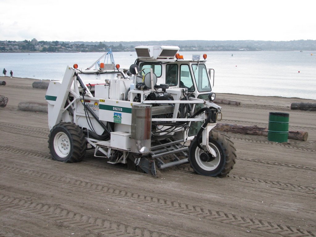
By early Sunday morning, the beach is clean, empty, and groomed (for more on grooming, see English Bay: August 2006).


Thursday, January 02, 2020

English Bay

Some pictures of First Beach on English Bay in Vancouver from a gray day a couple of weeks ago. I've posted many times from here before (Gravel Beach: English Bay) and don't have anything much to add this time.

But it's a favorite spot, no matter what the weather, and it seemed a nice way to close out 2019.

AERIAL VIEW


Saturday, August 05, 2006

English Bay


The beaches on English Bay benefit from their orientation (using groins) and added sand. They are just one element of Vancouver's magnificent, public shoreline, and are located between Stanley Park and the dense urban neighborhood sprouting along False Bay. The 13 mile seawall path allows bikers to go from downtown around Stanley Park and False Bay all the way to Kitsilano.

Four evenings every summer, the beach hosts a few hundred thousand people for fireworks. Each following morning, Vancouver Parks cleans up the mess and makes the beaches look like new again, with the help of big beach toys.

Monday, January 23, 2017

Second Beach


Vancouver has many small pocket beaches that face westward out into the bay and I've probably posted from most of them by now (a few links below). Second Beach, in Stanley Park is yet another of these. Like the others, it has been enhanced by the construction of structures that help maintain the pocket and also probably by the addition of sediment at some point.

AERIAL VIEW
Second Beach lies just east of the big pool (frozen over on this trip) which looks as if it was probably constructed out over the foreshore. This improves the configuration of the shoreline for the beach itself. There's also a rock groin at the east end which keeps Second Beach from spilling around the corner and joining the much larger, but similarly aligned, First Beach (but which is usually called English Bay Beach).

English Bay: December 2014
Third Beach: April 2007
Sunset Beach: August 2016
Kitsilano: April 2016
Jericho Beach: August 2008
Ambleside: October 2011

The Stanley Park seawall west of the Second Beach pool


Wednesday, December 31, 2014

English Bay


I've visited this beach many times, but my only previous post shows the beach under somewhat more crowded conditions (August 2008).  Today, there were no crowds, and no fireworks, but the sun came out in the midst of an otherwise drizzly weekend and made sitting in the bar at the Sylvia Hotel particularly nice.

AERIAL VIEW

All of Vancouver's beaches are turned to the west, since that's where all of Vancouver's wave energy comes from. This is true of the beaches on both the north and south shores of English Bay, as well as those in West Vancouver.  All of these beaches benefit from promontories, groins, or other structures at their eastern ends that facilitate their more beach-friendly orientation.  I suspect most of them also benefit from the periodic addition of sand brought in from elsewhere.  It's not that there wouldn't have been beaches here naturally, but they wouldn't have looked like these.


Saturday, August 09, 2008

Jericho Beach


Jericho Beach is a sandy crescent beach on the southwest side of English Bay, west of Kitsilano and east of Spanish Banks. I'm not sure what the beaches along this side of the bay looked like before steam shovels arrived, although I would have expected substantial eastward drift from Point Grey and maybe a more continuous beach east towards Kitsilano. Groins and other historic modifications have segmented this shoreline into a series of pocket beaches - and left no beach at all in some places. Next trip I'll have to explore Locarno and Spanish Banks.

I once heard that it suggested that these beaches are supplied by the Fraser - maybe, though I suspect the eroding bluffs at Point Grey are the more likely source. Not that the Fraser doesn't loom just around the point to the southwest.

Saturday, August 02, 2008

English Bay


Like horseshoe crabs on the beaches of Delaware Bay, penguins on the shore of South Georgia Island, and walruses at Cape Vankarem on the Chukchi Sea.

How about the small artificial pocket beach behind the riprap? It's even smaller than Seattle's Sculpture Park Beach. I think the Corps of Engineers, or the City of New Orleans, should hire the kids in the second picture - although I suspect their success can largely be attributed to the tide having already crested.

Sunday, April 19, 2009

English Camp


English Camp is located on the shores of Garrison Bay, near Roche Harbor on San Juan Island. It was established in the 1860s during efforts to solve the Pig War.

The old blockhouse was built over the bank edge and little has changed since. There's not enough wave action in this sheltered bay to cause much erosion - or even to form much of a beach for that matter. The beach is pretty muddy - wave action is necessary to winnow the fines out of a beach -- and the gravel is stable enough to grow barnacles and rockweed. Salicornia occupies the uppermost beach. The National Park Service has instituted some simple measures to reduce erosion - which generally work because they keep visitors from clambering down the bank.

This site is a little peculiar - the terrace on which the camp is built is too high. I should read some of the geo-archaeology reports done on this site - there was also a long native history prior to the Brits showing up - and find out whether they clarify the historical setting.

Wednesday, April 20, 2016

Point Grey Foreshore - Part Two


As I often do, I've done some homework on this shoreline, trying to find background material, interesting footnotes, and corroboration for some of my observations. One thing I found fascinating was that this was described as the last natural shoreline in Vancouver. I guess it depends on where you stand, and what direction you look. If you stand at the base of the bluff and look towards the green residential towers of downtown and the West End, the shore does indeed look natural. But if you stand on the foreshore and look landward, you see some of Vancouver's most expensive homes, some amazing seawalls, and none of the original forest.


Calling it natural makes more sense if you contrast it with much of Vancouver's other shoreline, which consists of a wonderful public promenade, built atop a spectacular seawall. You can walk or ride a bike from Canada Place on Burrard Inlet all the way to Kitsilano, following 11 km of paved trail around Coal Harbor, Stanley Park, English Bay, False Creek, and past Granville Island (Vancouver Seawall). The Seawall ends in Kitsilano and the path then follows an inland route west to Jericho Beach and UBC.

Stanley Park 2008
Yaletown 2011

There have been proposals to extend the seawall (the one with the promenade) west from Kitsilano to Jericho Beach along this northern shore of Point Grey, but these have been opposed by folks who want to see this shoreline remain as it is (Georgia Strait: July 2012).

For another perspective on the natural shoreline, and for those who like to mix interpretive dance with their coastal geology, Rewilding Vancouver is a reminder that nature is defined by humans, and we may all define it a little differently.


Wednesday, December 31, 2014

Jericho Beach


This beach has recently been remodeled (Vancouver Parks info) and if I'd had more time and the weather had been more pleasant, I would have checked more of it out. As it was, this was just a short visit on the way out of town after our Vancouver weekend.

Previous post: Jericho Beach, August 2008

Jericho Beach is one of several enhanced beaches (enhanced largely by the addition of shore-perpendicular structures that help capture the westerly waves) along the south shore of English Bay, that include Kitsilano, Jericho, Locarno, and Spanish Banks Beaches.  Sand is supplied from the broad shoals of Spanish Banks to the west, although the original source of this material may be retreat of the bluffs at Point Gray and the Fraser River. Maybe some was barged in, too?


AERIAL VIEW

Jericho Beach was originally the site of a flying boat station and later became a seaplane base for the RCAF. I guess that explains those strange ramps that are used by all the small boat sailing groups who use the park now.


Sunday, October 16, 2011

Myrtle Edwards Park


The beach and high bluff that marked the original shoreline is hundreds of yards inland at the foot of Queen Anne Hill.  Elliott Avenue, the railroad, and Myrtle Edwards Park are all fill (most derived from the leveling of lower Queen Anne and the regrade, I believe), which means the park's waterward edge drops pretty steeply to subtidal depths.


Most of the shoreline is riprap, which may be effective at preventing the fill from eroding back into the Sound, but which is ugly and makes getting to the water unappealing and difficult.  Shorelines are special places.  Industrial ones require industrial solutions, but public ones require imaginative and welcoming ones.  If rock is necessary, maybe an investment in better rock would be a start.  Vancouver has used large granitic boulders on its English Bay shoreline, which encourage sitting and even allow safer access to the water itself.  Sure it's more expensive, but it's also a nice place to linger, not just roller blade past.


But best of all is when the the configuration of the shoreline allows beaches.  This one is somewhat incidental, I believe, but could probably be expanded.  It flies in the face of anyone who would argue that the energy or the steepness of the shoreline preclude a sandier beach.


There is another pocket beach just down the shoreline at the Denny Street outfall - they added gravel to a small pocket a few years ago and it's shaped up nicely.  And a little beyond that is the Sculpture Park beach.  I'll add pictures of those in subsequent posts.  There is talk of incorporating beaches into the reshaped central waterfront, too.  I suspect as we move farther south, the beaches will continue to become progressively more engineered and less natural, although this may have more to do with design firms and big budgets than any natural limitations of the sites.  I'll put in a strong plug for imagination and for learning from natural examples.