Garrison Cove is tucked into the north end of Bailey Island, between the Cribstone Bridge and Cook's Lobster House. The beach is completely sheltered from anything but local waves, but the open ocean isn't far away.
AERIAL VIEW
I walked this beach after dinner at Cook's way back on August 20th. The next morning, I started riding back to Seattle. Beaches weren't my objective, but I found a few along the way.
A previous visit: Bailey Island: October 2008.
Showing posts with label Maine. Show all posts
Tuesday, November 26, 2019
Monday, August 30, 2010
Jasper Beach
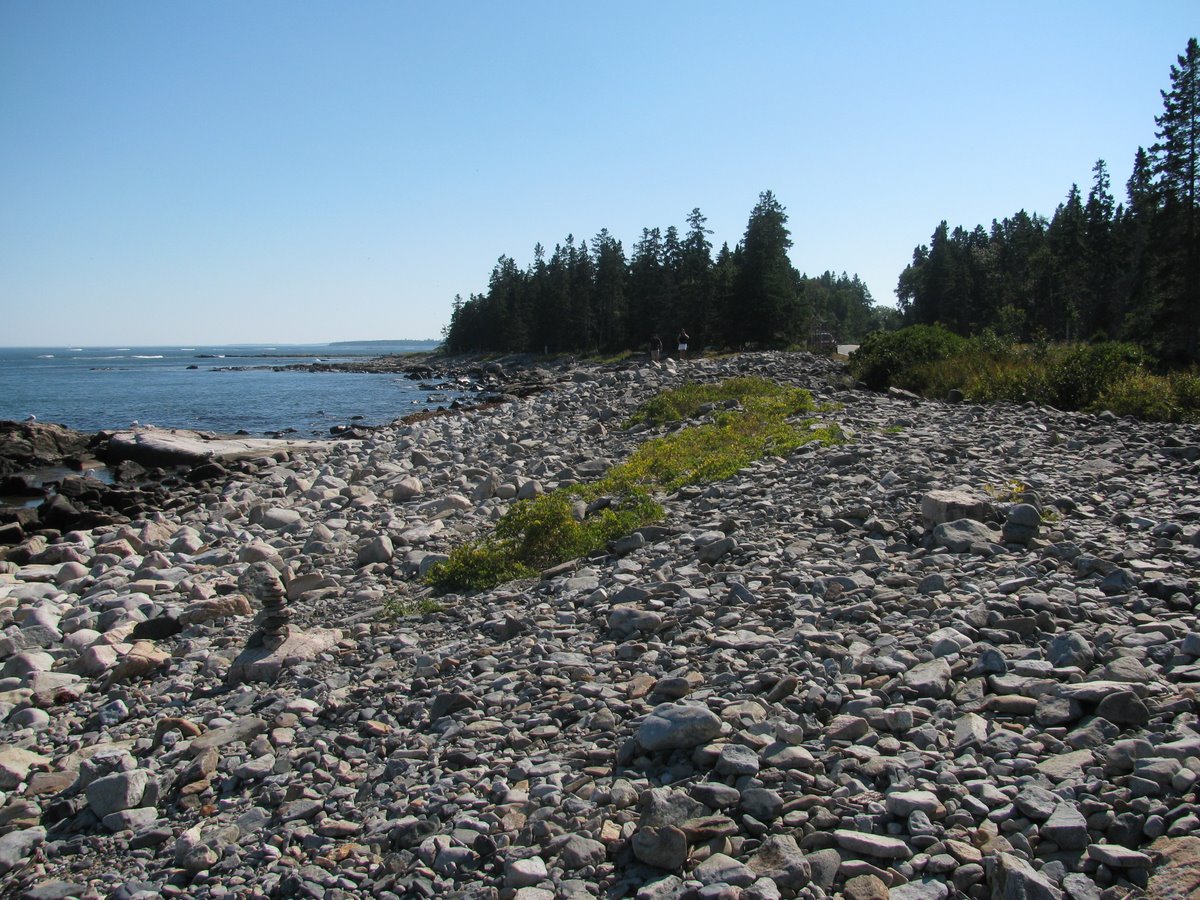
I'd only seen aerial photos of Jasper Beach before this visit, so I admit I was completely unprepared when I came to the end of the dirt road and found it blocked by a wall of gravel that extended a mile along the shoreline.
Most gravel beaches aren't really gravel beaches. They are mixed sand and gravel, sand with a surface veneer of gravel, cobble, coarse sand, and so forth. But Jasper Beach is a really a gravel beach. It looked like a training site for Maine DOT crews.
The beach face was broken into a series of berms - I'd like to call them swash terraces - and the seaward slope was incredibly steep, as might be expected on a beach with such uniform large gravel. Even with today's very gentle swell, the beach was noisy with rolling gravel.
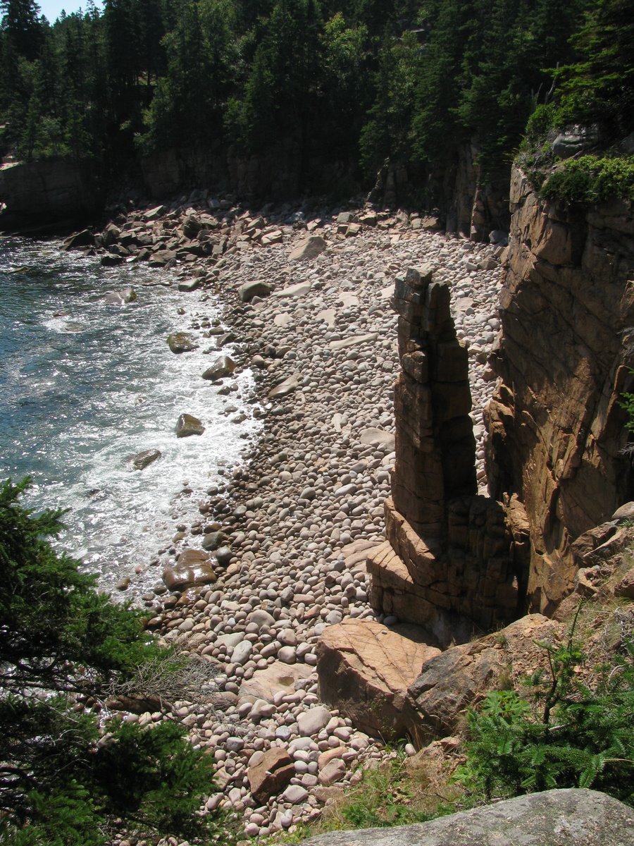
The main lagoon (lake) is behind the eastern end of the barrier, but the berm also cut off a small valley just west of the parking area, forming a stagnant pond. The berm had been breached here in the past (recent past?), based on a big divot in the gravel ridge and small gravel overwash fan.
Roques Bluff
The main beach at Roques Bluff State Park is a sand and gravel barrier separating Simpson Pond from the Atlantic.
There was a beautiful set of gravel cusps (gravel horns, sandy troughs) at the west end. You could also see the coarse gravel storm berm peaking out at the back of the beach from under the sand and the backshore vegetation. I suspect this beach changes significantly in appearance from summer to winter.
There is an interesting variety of beaches and bluffs to the east of the State Park, including a fast flowing tidal inlet and an impressive bluff completely armored in rock. I suppose there's a neat glacial deposit hidden underneath!
Cutler
This stretch of rocky coast north of Cutler is billed as Maine's Bold Coast. There are some big blocks of public land, providing access and preserving it from the development that would inevitably encroach on this wilderness shoreline. There were other cars in the small lot, but I saw no one else on my one mile hike out to the sea and back.
A couple of days later and the swell from Hurricane Earl might have made this even more impressive!
Sunday, August 29, 2010
Schoodic Peninsula
I suspect Schoodic Point is best known for waves crashing on its rocky headlands and that was the primary reason that I raced to get here before the sun set on my overstuffed day in Acadia.
The sunset was great, the rocky ledges impressive (but the waves today were pretty small). But what really impressed me were the boulder berms on the east side of the Point. Boulders and huge cobbles stacked along the shore, offering some sort of hint at what winter storms must be like along here. If only I had left more time to explore them! When I do come back, I'll also want to check out the gravel barriers around the pond on the west side.
Seawall Beach
I guess there is something a little oxymoronic about the name of this place, but it is also an advertisement for the inherent stability of coarse gravel berms. The gravel and cobble are piled up into a variety of configurations along the back of these rocky platforms. These photos were all taken within half a mile of each other. And there isn't a seawall in sight.
Little Hunter's Beach
Little Hunter's Beach is located at a small stream mouth in a equally small cove near Schooner Head on the south edge of Mount Desert Island. Its truly a gravel beach, in contrast to Sand beach or the boulders and cobbles at Monument Cove. I suspect this has more to do with the nature of the glacial source of this material than anything else.
Even in today's calm conditions, you could hear the gravel rattling up and down with the waves and watch the swash get sucked into the steep, permeable beachface.
As we've moved west along this coastline, the pink granite of the Otter Cliffs have given rise to a dark schist.
Monument Cove
Monument Cove is a small pocket beach, hidden in a cove between Thunder Hole and Otter Cliffs. It would be easy to miss and it looks difficult to get down to (I didn't try). I've seen this beach in dozens of calendar pictures over the years and it's cool to see it for real.
The grain size is huge compared to Sand Beach, just a mile or so away, going to show that you can't predict beaches on gross characterizations of geology or wave energy. The details matter. Source and abundance of sediment, orientation, and simply the antecedent history of the particular beach.
Sand Beach
Acadia National Park and Mount Desert Island, and this portion of the Down East coast in general, are better known for its rocky headlands than for its beaches, but there are beaches, and each is very different than the next.
Sand Beach, is just that. The sand is mainly shell fragments. It is a pocket beach - actually a barrier - with what appears to be an occasional outlet at its easternmost end. The beach is backed by dunes and a lagoon, then by forest and rocky hills. The back of the beach, at least at each end, lay against a coarse cobble berm. I suppose this may be much better exposed in February after a stormy winter than in August.
Friday, August 27, 2010
Rockland
Rockland Harbor is sheltered by a beautiful stone breakwater that extends across the north side of the bay from an armored headland (the golf course for the Samoset Resort). There was a nice little pocket beach tucked in on the inside of the base of the breakwater. It consisted of sand, gravel, and periwinkle shells. The beach wrack consisted of washed up fucus and apples.
Pemaquid Point
I'm back in Maine for a long weekend on the Down East coast.
There are beaches of one sort or another (all small) scattered around Pemaquid, but the point itself is a classic rocky headland. Like much of mid-coast Maine, the glaciers pretty much followed the metamorphic fabric so the strike of these tightly folded Paleozoic rocks parallels the point as it plunges southward into the Atlantic.
The waves today were modest, at best, and remain so throughout this trip. As I write this, one week later, Hurricane Earl is probably stirring up things a bit.
Subscribe to:
Comments (Atom)


