skip to main |
skip to sidebar
I'm playing catch up, so this post dates back to late May.
I posted from here a few years ago and mentioned wanting to see how it weathered over time.
Skyline: November 2012
AERIAL VIEW
This project, which extends about 1000' along the shore, is a complex crib consisting of stacked and interlocking timbers, reinforced with steel cables. It's relatively steep - definitely a revetment, not a beach! While it's easy to see how dirt would get eroded from behind the structure, it's more difficult to see how normal beach building processes (the movement of sediment up the profile by waves) can maintain or rebuild the berm. Loss of sediment has been remedied recently with the addition of small rock (angular, not gravel or cobble) in the eroded areas behind the logs.

The most vulnerable segment of this project is where the shoreline bends, creating a convex seaward curve - a small headland of sorts. This likely results in a steeper profile, more wave action, and a natural tendency for sediment to be moved away from the spot over time. This is in contrast to the concave seaward beach west of the project, where a small pocket beach is accumulating material (probably material eroded from the headland just mentioned).
This small pocket is at the location of the original tidal inlet, which was relocated to the east end of the spit when this area was (re)developed.
I've fallen way behind - a week in August on Salt Spring and another week driving back and forth from Minnesota in September resulted in some beaches being collected, but not yet stuck in the album. So I'll add them quickly - with abbreviated comments - so I can check this off my list.
This is a neat park on the site of the old Scott Paper mill. The site has been cleaned up. Two new breakwaters were installed to replace the dilapidated timber wall that used to protect this side of the entrance to Cap Sante Marina and to provide shelter for small boats launching from the new pier. There was always a small pocket beach in the cove on the park's north side, but the low tide beach is no longer a tangle of rotting wood and the upper beach is clean gravel, not broken bricks and debris.
AERIAL VIEW
There's a lot more that I'd like to add about this site, but that will have to wait for a future post.
A new beach (several, actually) and a very small pocket estuary. An amazing contrast to the remains of the old Custom Plywood mill. And probably quite a contrast to whatever marsh or beach marked this shoreline before the 1860s.
Here are two previous entries on this site:
AERIAL VIEW (probably out of date)

 These beach projects often rearrange themselves very rapidly after construction. After all, they involve placing loose sediment in places where waves and tidal currents are expected to move it around. This isn't necessarily a problem - good projects are designed to allow this kind of adjustment. But often these early changes are not well documented and as a result, we lose an opportunity to learn and to improve future projects. There will be some sort of formal monitoring of this site, but these programs often miss some of the most important (and often most interesting) geomorphic details.
On a brief, late afternoon visit, here's what caught my eye:
- A new flood tide delta was building inside the southern edge of the inlet, shifting gravel from the beachface into the lagoon.
- A mid-tide berm was building northward across the outlet channel, pushing it northward.
- The sandy crest of the outer spit was eroding on both sides, although more on the south. I wonder if this sandy material - and the beach grass - will make it through next winter.
- The beach to the north was looking pretty cool, but I didn't have time to explore further.

March's Point, or March Point? Either way, it's the peninsula that forms the eastern shoreline of Fidalgo Bay and is home to oil refineries and the piers necessary to unload all that Alaskan crude.
 Google Maps: AERIAL VIEW
It's also the site of one of the more interesting beach nourishment projects on the Sound in the last few years -- interesting in part because of its simplicity. The road follows the edge and erosion had cut away the bank, not only threatening the road, but eliminating the upper beach. This project (which I don't know too much about and will not say too much more about) involved placing gravelly sand along a stretch of beach and largely letting it figure itself out. Which it seems to have done very nicely and very quickly.
Sometime I'll come back and post about this project again - when I have more information and when the weather is more conducive to good photos. I actually have better photos from previous visits, but I try to build the blog around the photos taken at the time (which in this case was last Thursday).
There's a new beach taking shape in Anacortes at the old Custom Plywood site. The lumber mill closed down a long time ago and later burnt to the ground (or the water, since much of it was over water). They're currently cleaning up the toxic residue and redeveloping the site for a mixture of commercial and public uses.
Here are some earlier pictures - from back in the early days of the blog.
Anacortes: April 2006
Google Maps: AERIAL VIEW
 There's a lot going on here. The jetty at the north end is being extended, apparently to help shelter whatever ship yard or boat basin is planned for the north portion of the site. The southern portion of the site is dedicated to public use. A wetland, a small pocket estuary, will help buffer stormwater and restore some of the low energy habitat that may have once existed along portions of this shoreline.
 The wetland/lagoon is sheltered by an artificial spit/berm with a coarse cobble core - I guess to keep it from washing away, not that that's very likely. The new beach, complete with drift logs, is being built on the outer face of this berm, and the estuary drains through a new tidal channel. The new beach is in turn protected by another spit, a pseudo-spit of coarser material that curves out into the bay - sort of a naturalistic breakwater.
This will be a fascinating landscape to watch evolve over the coming years. The vegetation in the wetland will have to sort itself out - adjusting to the tidal regime and the salinity of the new marsh. The beach will adjust to the waves and to the dynamics of the little tidal inlet, but I suspect will do fine. I am looking forward to launching a kayak there next summer some time. The outer spit is an interesting concept, but I'm curious to see what kind of shorelines actually become established on both its inside and outside edges.
This large multi-unit residential project was proposed several years ago, but was delayed by the economy. Now things are underway again, with one of the first steps being the innovative log-crib erosion control structure.
I'm not quite sure what to make of this project - I can't think of anything like it on the Sound. It's an improvement over the seawalls farther east - in large part because it doesn't project as far onto the beach - but it will be interesting to see how it does over time.
For some more history on this area:
Skyline: April 2006
And to see what Flounder Bay has become, check out the view from above:
AERIAL VIEW


For decades, this beach on the north side of Weaverling Spit has been eroding back into the fill that was placed around the original railroad grade (now the Tommy Thompson bike trail). Pulling back the fill would probably have solved the erosion problem, but would have been hard to sell to the various parties involved. But building a seawall or dumping rock is also hard to sell these days and would have done nothing to restore the beach itself, so folks got together to develop a softer solution.
This nourishment project was completed last month and it seems like a good approach for this site. Sand and gravel was placed on the upper beach, old rock and concrete debris was either carted away or buried, and four anchored log groins (we euphemistically call low groins "drift sills" here - a Wolf Bauer term) were built, although I am not really convinced they are necessary. They add complexity, hard structure, and cost to what might have been a simpler project, but there are also good reasons for including them on some projects.
It will be fun to watch this site evolve - even just over the next few months. Conventional armoring goes in and not much happens visually - after all the purpose of a hard structure is to NOT allow change (many of the impacts of armoring, other than the ones associated with its initial placement, take time to emerge). But nourishment projects are intended to be flexible and like natural beaches, change with storms and seasons. In the process, they tell us much about the factors influencing a site.
Several things will be worth watching. There is already considerable rearrangement of the beach face going on, particularly at the west end where a distinct berm is forming lower on the beach. The stream outfall at the very west end interacts with the new beach and its delta may become a sink for some of the new sediment. There will be some spreading of gravel eastward from the project, although I doubt the volumes will be high. The most important changes will be in the evolution of the berm. Instead of building this project with a natural berm, the sand and gravel were just piled high against the bank. This material will gradually erode and be incorporated into the gravelly foreshore. A berm will slowly develop, allowing logs to accumulate, although logs build up slower on these north-facing shorelines (it's about the wind). The lack of a natural berm and the eroding material from the upper part of the project will keep this from looking like a natural beach for several years, but we should remember that shoreline projects should not be judged over the short-term.
There are some shots from nearby, though not this particular site, at:
Weaverling Spit: September 2009.
And if you want to check out the trail - just note that a fire on the trestle a couple of weeks ago closed the trail east across Fidalgo Bay from Weaverling.

 This site at the south end of Anacortes industrial waterfront reminds me of Dickman Mill in Tacoma before it was cleaned up. You can still see the beach and the shoreline trying to show through, despite the piles and the concrete and the thick layers of wood waste. These sites are fascinating 20th century archaeology, but they are also incredible opportunities. Maybe local priorities will see this redeveloped for marine industry, though cleaner and more habitat-friendly than last round. But it could also be a wonderful park - linked to the adjacent public trail, with historic interpretation, pocket beaches, and maybe even a small coastal wetland. Anacortes has already done a nice job converting other old industrial sites to public parks, while also maintaining a working waterfront.
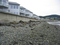
 This was once Flounder Bay, southwest of Anacortes. It is now Skyline Marina and the surrounding community (click on the title of the post to see the aerial). In the 1920s, there was a huge lumber mill built over the beach, remnants of which are still visible. Later there was a seaplane base. And in the late 1960's modern Skyline began to take form. It is one of several "canal" style developments that occurred during that period - others include Lagoon Point on Whidbey, Shelter Cove in La Conner, and Birch Bay Village. All were originally large coastal wetlands.
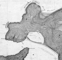
The historic maps show the original inlet to Flounder Bay at it's western, downdrift end, but at some point, the inlet was moved to the eastern end (never let nature get in the way of convenience). The eastern jetties isolate the spit from it's sediment source. In addition, the extensive fill placed on the spit probably buried whatever sand-gravel beach once existed. All that's left in front of the seawall is a starved cobble beach and old riprap. Maybe it's a good thing that the public access is limited! In another place and time, this would still be a natural spit and salt marsh and a park or it would be a developed spit with a destination resort, lots of public access, and a great beach. Either of which would be preferable to what we ended up with.


.jpg)

