skip to main |
skip to sidebar
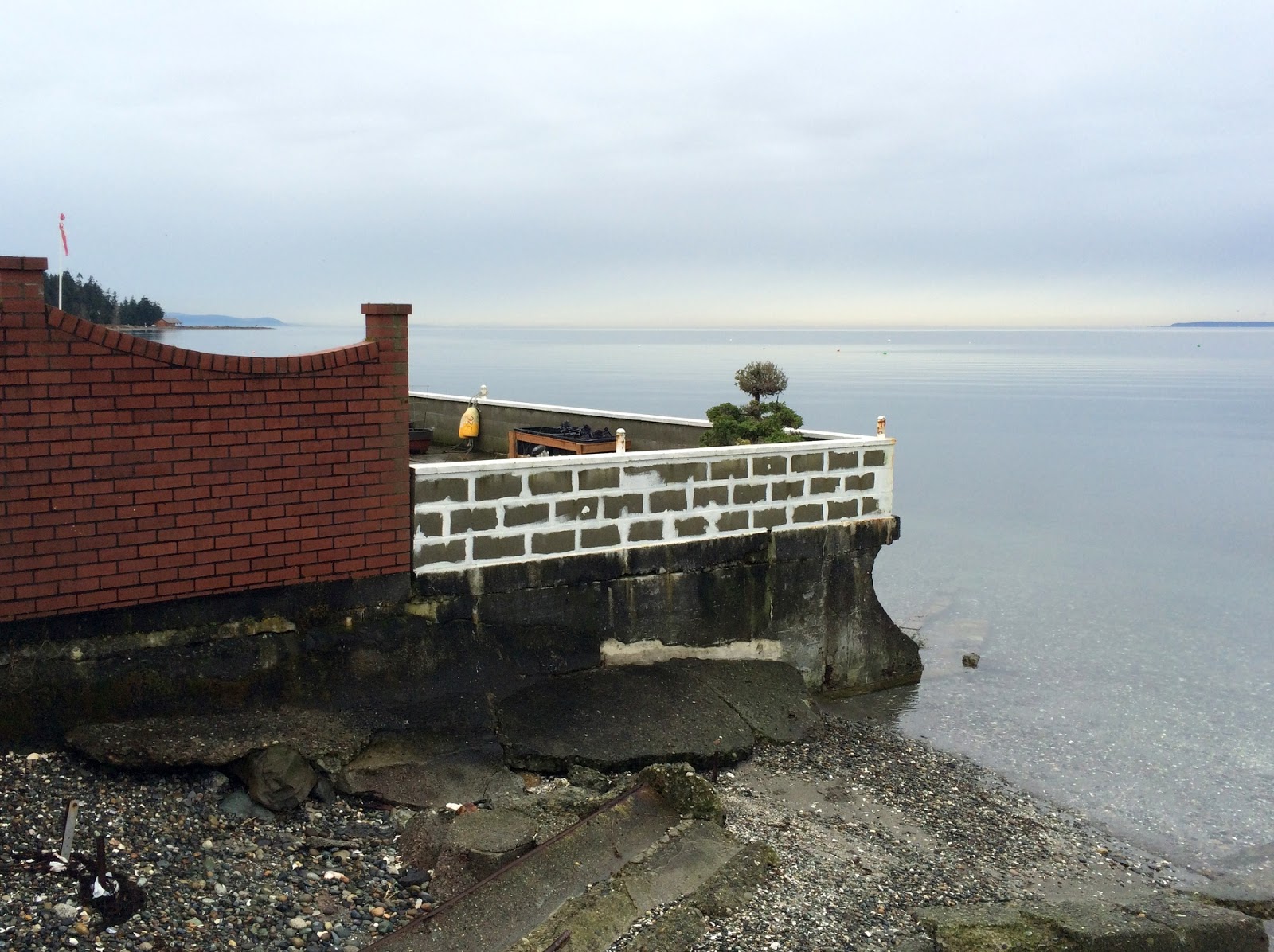
Marine Park lies just south of the Peace Arch in Blaine. I posted from here in January 2010 and again in April 2016. The peninsula on which the wharf district is built was created largely (entirely?) from dredged material (though probably of different vintages). The outer (northwestern) edge had been armored with rock and concrete and a variety of old debris, resulting in nice views, but an ugly shoreline where access to the water can be hazardous.
The one exception was a small beach that had formed where the ragged edge of the peninsula happened to offer an appropriate configuration. But this actually provides a very nice template for future work - since it shows what orientation, what sediment size, and what beach and berm profile works best. The best model for a created beach is the beach next door!
AERIAL VIEW
A couple of years ago the city began resculpting the edge and created a pocket beach. They improved the rock work at a couple of small promontories, excavated the rock and fill between them, and added gravel. Orientation is key on these pocket beaches and this one may still be adjusting. The mobile sand and gravel is wanting to stay in the northeastern half of the little cove, leaving the western end a steeper slope of coarse cobble and rock, but it looks like overall the project has worked out well.
This project was limited to just one segment of shoreline, but it sounds like there's interest in extending this approach to additional segments in the future. You still need rocky hard points to anchor and contain the beaches, but the rock need not be old construction debris. And most of the shoreline can be a series of small beaches.
Semiahmoo Spit reaches north across the mouth of Drayton Harbor - with a long narrow neck and a very broad bulb at its distal end. This large expanse was created when the marina was dredged and the dredge "spoil" was used to greatly increase the size and elevation of the spit.
AERIAL VIEW
The perimeter of the spit consists of an irregular pattern of modest banks eroded into the dredged material and low depositional segments likely formed by the gradual redistribution of material along the shoreline. That means much of this shoreline is constructed, yet behaves much as a natural beach. And other than at the neck of the spit itself (see below), there's been no need to armor the beach.
After numerous delays, a new phase of development is occurring on the outer edge of the spit, south of the existing resort. Fortunately, the development maintains a public trail system along the shore and has placed the new buildings fairly far back from the edge. Rather than try to fight the chronic erosion, the designers pulled the abrupt edge landward, creating more beach-like area. I say beach-like, because it's still fairly high and steep compared to a natural upper beach.
It looks great, but bears watching. The underlying reasons some segments of this shoreline were receding have not changed by reducing the height of the bank (any more than armoring an eroding bluff prevents the ongoing erosion of the beach itself). So we may find that the new beach continues to erode, probably as a low scarp. And ironically, by reducing the height of the eroding "bluff" we may have reduced the supply of sediment to the beach, which could result in more rapid erosion.
Again, this bears watching. If erosion continues, this might be a good place to consider a localized feed source - a periodically restocked pile of gravel that can meter out sediment to adjacent shorelines as it erodes. On the other hand, maybe this won't be necessary. And regardless, kudos to Blaine and the development and their designers for what they've done here. In another era, this would have all been riprap.
Speaking of riprap, the real problem at Semiahmoo is the neck of the spit (aside from the clever idea to build a destination resort on a sand spit). Narrow and low - armored on both sides - the roadway is increasingly a causeway. And increasingly vulnerable - even at today's sea levels. (No pictures this trip - maybe next time). There have been some efforts to rebuild a berm on the inside (low energy, marshy), but they may need to be more ambitious. And the outside may require some serious thinking - maybe a coarse gravel cobble revetment of some sort? It probably won't be easy or cheap, though maybe throwing some coarse gravel at the south end would be a useful experiment?
Previous posts from Semiahmoo:
Tongue Point: March 2009
Semiahmoo: March 2009
The north end of Birch Bay was once a marked by a large complex of spits and marshes. Drift was eastward into the bay, carrying sediment from Birch Point to form a series of spits that terminated in an inlet at the northern corner of the bay. The spits and marshes probably recorded a wonderful chronology of sea level change, geologic events, and early first nations occupation.
AERIAL VIEW
In the late 1960s, it all became Birch Bay Village. The wetlands were dredged to create lakes and a marina. The sediment was used to create dry land for homes and golf. A new inlet to the new marina was cut at the base of the spit and the old inlet was left to drain a very small remnant of the original marsh. Drift rapidly built a broad fillet against the west jetty and the downdrift beaches were starved of their natural source of material (though sediment dredged from the inlet is now periodically bypassed to those beaches). Wolf Bauer and Maury Schwartz both used Birch Bay Village as an example of what not to do to beaches.
These pictures were taken at the inlet and near the west end, where the bluff ends and the spit begins. They show the beach west of the inlet, the jetties, the seawalls east of the inlet, and a remarkably large rock buttress on the first bluff property to the west.
A cold, clear day at the southern end of the Strait of Georgia. The wind was blowing out of the Fraser Valley but that meant this section of southwest facing beach was remarkably calm (farther south, Mukilteo and Edmonds were getting hammered by waves).
Gulf Road ends at this wonderful little stretch of beach, just south of Cherry Point. While there are bluffs in the distance in both directions, this section is a barrier beach with a nice back-barrier wetland, fed by two small streams. An old conveyor extends across the beach, dating to some unknown (by me) operation decades ago.
The roadway is eroding - as roadways on beach berms usually do. It would be neat if they could rethink this shoreline a little - maybe remove the road prism from the berm, restore the altered parts of the wetland, and make some simple public improvements - restrooms, some interpretive signage, some trails.
This shoreline reach extends from Point Whitehorn at the north, south to Sandy Point, a large, heavily developed spit that extends south into Lummi Bay. Sediment transport (beach transport, at least, I can't speak for finer grained sediment farther offshore) has always been a little controversial here. South winds are common, but the influence of a very large fetch to the north is significant and may be more important for drift. I mentioned this in a previous post from Point Whitehorn (March 2015).
AERIAL VIEW
There are three major industries along this shoreline -- a refinery (BP) to the north and another refinery (Phillips) and an aluminum plant (Intalco) to the south. The recently proposed Gateway Pacific Terminal, which was set back by the Corps last spring, would have extended offshore just north, between this site and the BP pier in the distance.
Previous post from here:
Gulf Road: March 2010
Marine Park in Blaine, just south of the Canadian border, is located on the northwestern edge of a large peninsula built out of fill when they dredged their port and marina. The shoreline edge is pretty ragged and was composed of rocky headlands formed from old concrete and rock debris and a few scattered, somewhat accidental beaches. I visited it six years ago when the City was contemplating improvements to the park's shoreline (Blaine 2010).
AERIAL VIEW
One segment of the shoreline has recently been fixed up. The concrete has been replaced with better constructed and more attractive riprap promontories and the pocket beach has been enhanced. The idea of taking advantage of the existing headlands is a good one and it facilitates the creation of stable pocket beaches. There's probably more that they could do along here, but this is a great start.
There were signs of some erosion of the bank just north of the large log and root wad (see pictures). This isn't anything serious, although it bears watching. I wonder if it's a result of last months high tide storm interacting with the large log that's been placed on the bank. This log, which includes a big root wad, seems too high to have just floated in, so I assume it's an installation. As we've seen on other sites, there's some risk associated with placing big wood high on a steep profile - - it may eventually get undermined. But then it roll down to a more natural place on the beach.
The northern half of Birch Bay's eastern shoreline is a long curving gravel barrier beach, separating the bay from extensive wetlands farther inland. Birch Bay Drive pretty much follows the original berm and there isn't much high tide beach left - what wasn't buried by the road has eroded away to a narrow strip, much of it covered in riprap or a concrete seawall. Dozens of small groins reflect an early, and not terribly successful, attempt to hold the beach together (Birch Bay - Part Two: March 2015).
AERIAL VIEW
Except for the groins and a few big storm drains, the beach is pretty much continuous and accessible, from the north end south to the mouth of Terrell Creek. South of the creek, things get sort of ugly, but that's another story (Birch Bay - Part One: March 2015). There is one other exception - a notable one.
M and I had a Sunday afternoon appointment in Blaine and stopped in here for lunch beforehand. It was quiet and our table was just a few feet above the beach - and considerably seaward of the high water line. This might be pretty exciting on a stormy day, but I guess that's why they have those shutters that can be pulled up to cover the lower portion of the windows. Keeps the gravel from breaking the glass, the salt water off the carpet, and the logs from landing on the tables.
There are major plans to rehabilitate the beach in next year or two, fulfilling portions of a vision Wolf Bauer laid out almost 40 years ago. He imagined a wonderful public beach stretching along this entire shoreline -- I guess they'll sort of have to build it around this place.
The gravel wasn't going anywhere on this very calm day several weeks ago!
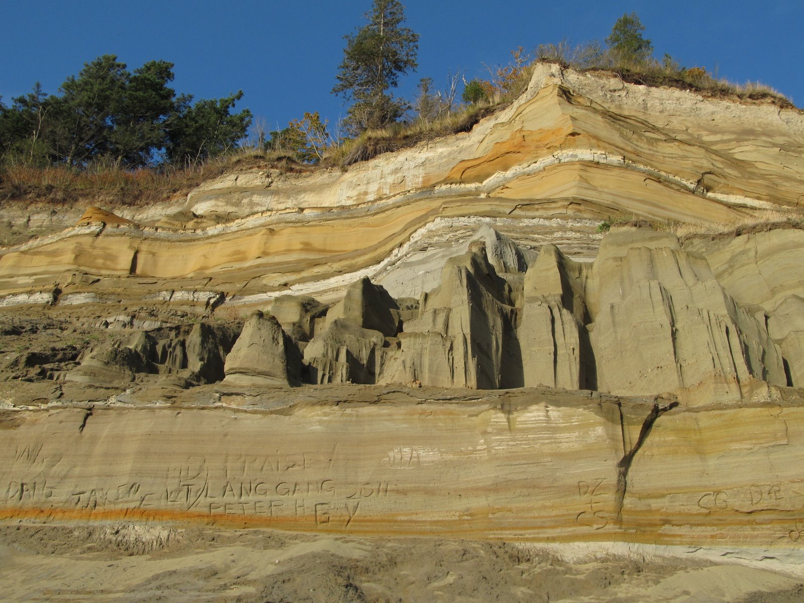
The Point Whitehorn Marine Reserve provides access to this coarse pebble beach just south of Point Whitehorn itself and a short distance north of the pier at BP's Cherry Point refinery. A short trail through the woods leads to a set of stairs down to the beach. One benefit of the industrial zoning along this reach is that the rest of the shoreline is relatively untouched - anywhere else it would be a continuous line of 5000 square foot houses, beach stairs, and seawalls!
Eroding till and glacial marine drift (I think both are present along here) provides a stream of coarse gravel and boulders that arrive by occasional landslides. A quick glance at the bluff face identifies more boulders that will join those on the beach in coming decades. The beach is coarse - mainly pebbles and coarse gravel -- but with patches of finer gravel and sand below recent slides, in the lee of large boulders, and occasionally just smeared out along the upper beach for no apparent reason.
AERIAL VIEW
The direction of sediment transport along here has always been a little controversial. Predominant southerly wave action would suggest northward transport, but Sandy Point, the large spit a few miles south of here, sort of indicates the opposite. The argument for this is that the large fetch from the northwest might allow less frequent, but more powerful wave events to move stuff southward.
Just today - and unrelated to my recent visit - I received a copy of Meghan Weaver's thesis (thanks, Scott). I haven't had a chance to look at it in detail, but she traced cobbles using RF tags and used models to get at this question. Most of her cobbles moved northwest in response to southerly wave action during experiments in winter, 2012 - but a major storm with waves from the west showed that the largest waves may be able to move significant amounts of material a long ways in the other direction.
Fetch, and therefore the largest waves in this fetch-limited system, may be be crucial to understanding long-term patterns in coarse sediment transport, even if the sense of direction is different than that dictated by more routine wind and wave patterns.
Meghan also makes some other important observations about the importance of the tidal stage in influencing patterns of movement and about the relative mobility of the upper and lower foreshore (material moves more on the upper beach). Ultimately, what she shows is that simple models of longshore sediment movement are ... well, simple. So neat to have a new generation of geologists that are actually using data and realistic models to get at things the rest of us have been speculating about for decades!
Another post from Birch Bay, this one a little farther north along Birch Bay Drive. Unlike the residential section in the previous post, here the road follows the beach, the development is landward of the road, and the beach is both public and accessible. Unfortunately, the roadway itself and subsequent erosion has left little of the original backshore and the upper beach is littered with old seawalls, riprap, and a long series of concrete groins. It's a mess.
In the 1970s, Wolf Bauer (who just celebrated his 103rd birthday) proposed an ambitious gravel berm and enhanced public right-of-way along this stretch. Now, 40 years later, a somewhat scaled back version may actually get built. Funding has been found, plans have been drawn up, and maybe in a couple of years we'll get a new beach, a big boost for the community, and a road that doesn't get pummeled with gravel every time a storm comes through.
AERIAL VIEW
Previous posts:
March 2010
March 2009
I read recently that although blogs have few rules, one should always endeavor to post regularly. Hah! Collecting beaches is a hobby. Sometimes work, family, or even other hobbies, can intervene. Sometimes I fall behind. In some cases, I simply don't get to the beach. In others, I get to the beach, but can't seem to find time to post. In the last month, my shoreline trips have been few (and often gray and drizzly) and my distractions have been many, so a number of potential posts have simply stacked up in a pile of JPGs on my hard drive. I will try to dribble a few out over the next few days.
AERIAL VIEW
This is the first of two posts from Birch Bay - collected on a trip to Whatcom County several weeks ago. Birch Bay opens to the west onto the Strait of Georgia and its inner shoreline forms a broad crescent, formed and reinforced by refracting waves. Longshore drift along the bay's beaches is generally from south to north, helping to explain why the mouth of Terrell Creek is deflected almost two miles north by a long spit.
The stream-mouth spit begins in the State Park, but its northern half was developed ages ago and is lined with beach houses and bulkheads. The encroachment of the structures across the upper beach is probably due in part to how they were originally built and in part to the progressive erosion of the beach itself -- either way, there's not much high tide beach left along here!
This past year, a new beach took shape in Bellingham at Boulevard Park. The park inherited a large area of historic fill on which a log mill once operated. Unattended, fill tends to erode away, and to prevent this the foreshore was covered in riprap and old concrete debris. The lawn was a nice place to listen to a concert or throw a frisbee, but getting to the water was a treacherous walk through a dump.
For many years folks have talked about making this shoreline more friendly, and finally, last year, the city went forward with plans to excavate some of the old fill, reconfigure the edge to complement the incoming waves, and construct a gravel beach. This was the first chance I'd had to visit since it was completed.
AERIAL VIEW
Orientation is a key factor on these sites and sometimes the shoreline you're given isn't consistent with a stable pocket beach. In this case, the local designers employed a rock groin at the northeast end and even added a small rock hook at low tide to keep gravel from getting away. I understand there is still considerable offshore aerial transport of the pebble, but it would take a lot of kids throwing a lot of rocks to put a big dent in the local sediment budget. And the waves will tend to move some of them back - with time.
Now if the city could figure out how to clean up the rest of the debris along this shoreline, this could become the crown jewel of what will ultimately become a wonderful string of pearls along the Bellingham waterfront!
If the Puget Sound shoreline has a start and an end, this would be Mile 0, at least for those of us who think from left to right (and who consider PS to include entire U.S. portion of the Salish Sea). It is also Mile 0 of the 49th parallel, at least the part of it that forms the boundary between the U.S. and Canada. It's a straight shot from here east to the Lake of the Woods (Minnesota/Manitoba).
The big trees on the bluff (which are nicely displayed on the trail down to the beach) suggest this bluff isn't eroding terribly fast. The beach to the south had a fairly wide berm (consistent with the slow bluff erosion).
I've noted before that this beach is one where it is possible the net drift direction has changed due to the construction of the ferry terminal and causeway on Roberts Bank, which forms a pretty effective breakwater for storm waves coming down the Strait of Georgia, although it's not clear to me what effect that would have on a straight stretch of beach like this.
I visited this same beach from the north several years ago (49th Parallel: August 2007).
In both cases, I didn't wander too far across the line.
Lily Point itself is a low cuspate foreland (recurved spit?), but the bluffs that surround it are high and steep. The south bluff contains a large deep-seated landslide (Lily Point: August 2011), whereas the north bluff is a simpler, but even more spectacular cliff of either glacial outwash or older fluvial sediments (paleo-Fraser River??), although I suspect the story is more complicated than that.
This bluff dumps an awful lot of sand onto the beach - and the beach to the north widens quickly to form a small barrier. Two miles north, after another section of cliffs, this beach becomes the Maple Beach described in the previous post.