Showing posts with label point roberts. Show all posts

Saturday, August 23, 2014

Centennial Beach


Technically, this post is slightly out of order, since I meant to post it after Beach Grove and they sort of go together. Centennial Beach is just updrift (south) of Beach Grove and is essentially the Canadian extension of Maple Beach on the U.S. side.

AERIAL VIEW


Centennial Beach is just the most recent of a series of spits and wetlands that have formed on this northeastern shore of Point Roberts, much of which is encompassed within Boundary Bay Regional Park. The aerial view provides a nice glimpse of the complex geomorphology of this area.


Causeway Beach


Causeway Beach is basically the southern edge of the causeway that serves the Tsawwassen Ferry Terminal. I don't know how much intention went into building this beach, or whether it is just an artifact of the gravel-size material eroding out of the armored fill. Regardless, this beach would not have been here before the terminal was constructed - this was just the wide flats of Roberts Bank.
AERIAL VIEW

The beach has an impressive fetch to the south. Its orientation makes it unlikely that it has any significant source of coarse sediment, other than from itself. And it's not a uniform width - it undulates along the south side of the highway - in some places there is a wide backshore (little more than a rough gravel parking lot) and in others it narrows to nothing and the roadway is protected by newer riprap.


Beach Grove


Every year, I end up in Richmond or Tsawwassen early on a Saturday morning in August, prior to catching the ferry over to Salt Spring Island.  And every year, I have a choice of beaches to visit. This year, I went back to Beach Grove (2009) and Centennial Beach (2009).

AERIAL VIEW
Beach Grove is built on low land - old spits, marshes, that kind of stuff - on the eastern side of the Tssawwassen-Point Roberts hill (once an island, before claimed by the growing Fraser River delta). It receives beach sediment from Lily Point and Maple Beach to the south, although most of this material probably wound up in the series of spits that form Centennial Beach. Most of Beach Grove's shoreline consists of a narrow foreshore in front of a continuous lone of concrete seawalls. Offshore are the broad tidal flats of Boundary Bay.

Beaches can be narrow for a lot of reasons. In this case, I suppose they include 1) a dearth of coarse sediment from the south, 2) the fact that the community was pretty much built on top of the berm and backshore, and 3) the broad fine-grained flats essentially bury the intertidal beach (the flats intersect the beach face at a very high tidal elevation).


Tuesday, August 28, 2012

Roberts Bank


The Fraser River delta extends out into Georgia Strait, forming the large, shallow Roberts Bank.  The Tsawwassen Ferry Terminal is located at the end of a long causeway that extends across Roberts Bank to end just short of the U.S. border.  A parallel causeway a couple of kilometers to the north serves the large coal and container terminals.

AERIAL VIEW


The two jetty-like projections have undoubtedly mucked up circulation and sedimentation patterns in the vicinity, but they sure move a lot of ferry passengers to Vancouver Island and a lot of Rocky Mountain coal to steel plants in Japan and Korea.


Sunday, October 16, 2011

Monument Park


If the Puget Sound shoreline has a start and an end, this would be Mile 0, at least for those of us who think from left to right (and who consider PS to include entire U.S. portion of the Salish Sea).  It is also Mile 0 of the 49th parallel, at least the part of it that forms the boundary between the U.S. and Canada.  It's a straight shot from here east to the Lake of the Woods (Minnesota/Manitoba).


The big trees on the bluff (which are nicely displayed on the trail down to the beach) suggest this bluff isn't eroding terribly fast. The beach to the south had a fairly wide berm (consistent with the slow bluff erosion).


I've noted before that this beach is one where it is possible the net drift direction has changed due to the construction of the ferry terminal and causeway on Roberts Bank, which forms a pretty effective breakwater for storm waves coming down the Strait of Georgia, although it's not clear to me what effect that would have on a straight stretch of beach like this.


I visited this same beach from the north several years ago (49th Parallel:  August 2007).  In both cases, I didn't wander too far across the line.


Lily Point


Lily Point itself is a low cuspate foreland (recurved spit?), but the bluffs that surround it are high and steep.  The south bluff contains a large deep-seated landslide (Lily Point: August 2011), whereas the north bluff is a simpler, but even more spectacular cliff of either glacial outwash or older fluvial sediments (paleo-Fraser River??), although I suspect the story is more complicated than that.


This bluff dumps an awful lot of sand onto the beach - and the beach to the north widens quickly to form a small barrier.  Two miles north, after another section of cliffs, this beach becomes the Maple Beach described in the previous post.


Maple Beach


At low tide, one can practically walk across Boundary Bay on the sand flats, but at high tide the water comes right up to the seawall.  The upper beach and the berm of this sand spit is long gone beneath the roadway, although in recent years, nourishment has been used to rebuild the beach and provide protection to the wall itself.


Maple Beach:  August 2006


The beach derives much of its coarse sediment from the bluffs at Lily Point south of here.  And this beach is just the base of a much larger system of historic and modern spits that extends north across the border to Centennial Beach and Beach Grove in Tsawwassen.

The "C" on the marker might stand for Canada, although I suspect it does not.  The border is a bit of a groin and the seawalls are just as impressive north of the border as south.

Sunday, August 07, 2011

Lily Point


Lily Point would have made a spectacular resort or development, but it makes a better park. Lots of hard work over many years led to its acquisition and recent dedication as a park and a marine reserve. This is the forested southeast corner of Point Roberts, a few steps removed from the residential development of Maple Beach to the north and of South Beach and the Marina to the west. For most Americans, visiting it requires a passport, since you must cross the border (twice) to get here.

From the tip of the point, you can look south to Lummi Island and Mount Constitution, northeast to the high rises of New Westminster and Burnaby in the Fraser Valley, and southwest to the Gulf Islands. On a clear day, Mount Baker rises to the east.
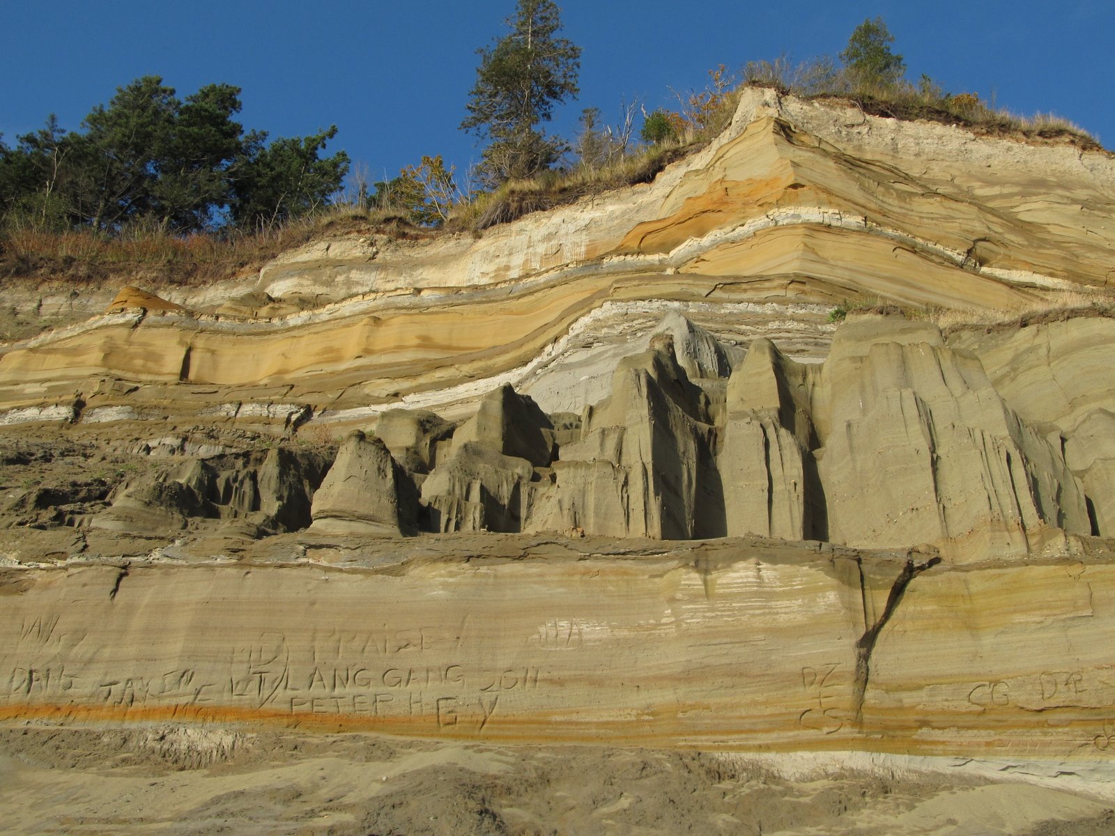
Lily Point itself is a cuspate foreland, bracketed by high bluffs. The bluffs to the north are bare and steep. The bluffs to the west consist include a large, deep-seated landslide, and is well-forested except in its steepest sections. It has all the classic symptoms --soft clay exposed on the beach itself, a steep shore bluff and a steeper head scarp, separated by a forested bench. I don't know how often it moves, but in the late 1990s, local residents in the area reported noise and dust when a big section let go.

Waves from the south erode the southwest bluff, carrying sediment both west to South Beach (where the sediment is periodically bypassed around the marina entrance) and north around the point towards Maple Beach. Maple Beach in the U.S. and Centennial Beach and Beach Grove on the B.C. side are part of a large complex of spits formed over the millennia by the erosion of Lily Point and then incorporated into the fringe of the Fraser delta.

Lily Point is by no means pristine and over 100 years ago it was the site of a major salmon cannery - remnants of which mark the beach on the north side of the low point. Native Americans/First Nations peoples apparently fished the point historically, but neither they nor the salmon were much of a match for industrial fishing.


Sunday, August 16, 2009

Centennial Beach


Lily Point, at the southeast corner of Point Roberts, has been feeding sediment to the beach for millenia and waves have been sending it north to form the beaches that extend from Maple Beach
on the American side into Beach Grove on the Canadian side. Yes, several thousand cubic yards of American dirt going to Canada every year -- no charge, no duty, no intention to return. The sediment has accumulated in a series of prograding spits in the northwest corner of Boundary Bay, where they created the large marsh behind and beneath Beach Grove - now diked and managed to accommodate the growth of suburban Vancouver (this is all part of Tssawwassen).

The long history of accretion means there's a broad sandy backshore, and even some semblance of low dunes. The upper foreshore is a narrow band of gravelly sand, running along the edge of the broad flats of Boundary Bay. The transition between the upper foreshore and the flats occurs at mid-tide or above. The lower beach appeared to be a lag surface of small gravel.

What I found intiriguing was the strong southeast-northwest fabric to the lower beach - a pattern seen both in gravel ridges (amplitude of ten cms or so and wavelength of several meters) and in the sand between them (amplitude of mms and wavelength of several cms). Strange. These did not look like ripples or cusps or any sort of depositional feature - they looked more like erosional features (I'm not sure why I felt that). And their orientation was parallel to the large fetch from the southeast - where I might have expected just the opposite. It looked like a surface that had been scoured by strong southeast winds and waves. As with every beach, there is a story here. I just don't have much clue as to what it is.

Monday, August 27, 2007

49th Parallel


There is a nice overlook and a trail down to the beach where the big gas-pressurized electric cables cross to Vancouver Island - or so I learned from the sign. Then I walked south to the minimally marked border. I guess anyone who tries to sneak in to the States via Point Roberts is sort of foolish anyway -- it's basically a dead end. I didn't want to do anything to alarm the guys at Homeland Security, so I didn't stray to far into the U.S. Maybe a little, but it was for the sake of photos and geological observations, right?

This is a nice gravel beach with a very broad sandy low-tide terrace (it's basically the outer part of the Fraser Delta). If the causeways have reversed long-term net drift directions, it sure isn't obvious here. There's some evidence of erosion, mainly at the foot of old slides, but for the most part the bluffs looked pretty stable. There's a broad backbeach and large firs growing on the face of the slope. There is a large drainage outfall structure just on the Canadian side of the line with a small stream dribbling out onto the beach.

The Canadian side of the border has big homes hanging over the top of the bluff, but Monument Park on the American side looks like a wonderful forested shoreline. I'll have to visit it some day - but I'll come in from the American side!

English Bluff


English Bluff is the western side of the Point Roberts peninsula. The Canadian side is considerably more built up than the American side (it's basically suburban Vancouver). Homes line both the top and the bottom of the bluff. Amazing variety of bulkheads and foundations. It looks like they're on sewer at least, judging from the manhole covers in the beach.

Tsawwassen


Point Roberts began as an island in Georgia Strait, but thousands of years of sedimentation has subsequently attached it to North America as the Fraser Delta has engulfed its northern end. Now it's a Canadian peninsula that hangs down into the U.S. Last year I explored the American side (Lighthouse Park and Maple Beach). This year, I checked out the Canadian side.

Tsawwassen, which is an extension of aptly named Delta, B.C., is the site of two major causeways that extend out to the deep water at the edge of Roberts Bank. The first causeway connects to the Deltaport industrial complex, where coal and containers are loaded and unloaded. The second causeway serves the BC Ferry Terminal and extends southwest almost to the waterward extension of the U.S. border.

A gravel beach has formed on the south side of the ferry causeway, maybe from the fill material originally used to build the roadway? A pocket beach has built in the corner formed by the causeway and the original English Bluff shoreline, presumably as a result of northerly transport of material in the lee of this unintentional breakwater.