skip to main |
skip to sidebar
Wind, and therefore waves, blowing down Lake Michigan (on both sides), results in southward sediment transport and the accumulation of sand towards the south end of the lake. Here on the southeastern corner, the sand has built a robust series of dunes (many of them now well back from the advancing shoreline and largely transformed into forested ridges separated by linear wetlands).
These photos don't show it, but I could see the Chicago skyline across the lake (still a long ways away). What you do see in these photos are the stacks of steel mills and generating plants in the middle distance. It's nice that the Indiana Dunes (a State Park) preserve some natural shoreline on a coast that has suffered historically from intense industrial development (and much now in disrepair).
AERIAL VIEW
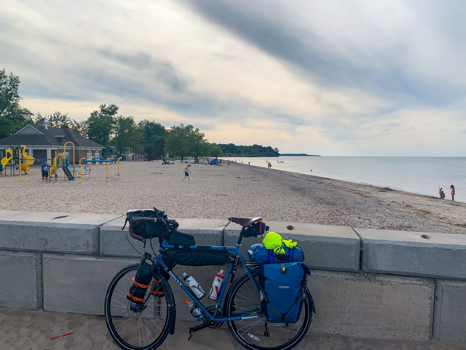
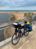 Ironically, today's wind was blowing strongly from the south and this leeward shore was welcome relief. I actually modified my route the last couple of days specifically to avoid the strong winds blowing north along Michigan's shoreline. By tomorrow (September 4th), unfortunately, they will be from the north again as I turn the corner and ride into Chicago.
My route west paralleled the shore of Lake Ontario, but was generally far enough inland to miss most of the shoreline itself. One exception was at Sodus Point, where I rode out to the beach and followed the 'coast' for a few miles west before heading south again. These photos were taken back in late August (yes, I am a long way behind).
The north-facing shoreline of Lake Ontario in New York State consists of bluffs and a series of barrier beaches built across the mouths of north trending valleys. I'm not sure whether to call the drowned stream mouths and lagoons behind the barriers estuaries or not - it sort of depends on whether you define estuaries around salt water (this is a freshwater system), or around their physical geomorphology (which works for me).
AERIAL VIEW
I don't know much about this shoreline, other than from a few articles over the years and from what I can infer from the maps and imagery. Sediment transport along the beaches is generally from west to east and this is clearly shown by the assymetric build up of material at jetties. Big wide beaches on the west sides (like here at Sodus Point), and very thin, sketchy barriers on the east sides.
The Great Lakes have been running pretty high and Lake Ontario is no exception. This fall there were news stories about funding efforts to address flooding and erosion at a variety of spots along this coast both east and west of Rochester (including the sediment-starved barrier immediately east of these jetties). Water levels on the Great Lakes vary over cycles of many years as the large watershed is a great integrator of long-term regional hydrologic patterns.
I don't think beaches are pervasive features on lakes in the Adirondacks, but they are found locally. In most cases, the forest comes right down to the water's edge and I guess there's not enough sediment, and not the appropriate wave environment, to maintain beaches. But the presence of coarse-grained igneous rocks (anorthosites) that
erode to form sand-size material and a glacial legacy of scour and
redeposition suggests to me that enough sediment might be available in some places, if the wind and wave conditions are sufficient. On the other hand, a cursory look at Google's imagery suggests that many of the small beaches may have benefited from a human hand (and some dump truck loads of sand).
I spent a night in late August near this one on Long Lake. Which was long enough to appreciate the beautiful evening and subsequent morning, but not enough to actually learn much about the beach or even the local geology.
I did learn that the one thing that all beaches in the Adirondacks have in common are the chairs.
Garrison Cove is tucked into the north end of Bailey Island, between the Cribstone Bridge and Cook's Lobster House. The beach is completely sheltered from anything but local waves, but the open ocean isn't far away.
AERIAL VIEW
I walked this beach after dinner at Cook's way back on August 20th. The next morning, I started riding back to Seattle. Beaches weren't my objective, but I found a few along the way.
A previous visit: Bailey Island: October 2008.
Excuse my long absence, but this year has been complicated and I've been a little distracted.
These photos, from July, are of Meydenbauer Bay Park in Bellevue. This is a brand new beach and a wonderful example of how a beach encourages interaction with the water. It's not what this shoreline looked like historically, and definitely not what it looked like before the forest was cleared, the lake level was dropped, and the city was built, but it's a wonderful addition to the Lake Washington shoreline.
AERIAL VIEW
Over the last several months, I've accumulated a pile of beach photos and with some luck I'll dribble them
out over the next few weeks. I'll probably try to stick more to photos and less to narrative, in part for expediency and in part because many represent very brief visits to places I know very little about - not that that's stopped me from rattling on in the past.
The presence of my bike in the lead photo reflects a pattern that will be repeated in many of the subsequent posts. I seem to have taken very few photos in the last few months that don't have the bike in them.
Another lake, this one in north central Washington, visited during my winding drive back from Montana a couple of weeks ago.
Omak Lake has no outlet. It's a low spot in an ancient channel of the Columbia River that has been subsequently occupied by the advancing ice sheets. While the shoreline shows evidence of fluctuating water levels, I guess there isn't enough precipitation to keep up with evaporation (or subsurface drainage?). Much of the shoreline is bedrock, but there are beaches in a few spots where abundant sand and large enough waves cooperate.
Besides shaping the landscape, the glaciers left erratics picked up elsewhere. The top photo show one along the edge of the lake itself. But the main objective of this little side trip was Balance Rock, perched on a small eroded pedestal high on the slope south of the lake.
The small city of Sandpoint, Idaho, lies at the northwestern end of Lake Pend Oreille, near its outlet to the Pend Oreille River, which in turn flows into the Columbia just north of the Canadian border (although it has to first flow through the powerhouse at Seattle City Light's Boundary Dam in order to generate some of the watts that run my computers and my air conditioner).
The Clark Fork River is the largest inflow to the lake and drains a large portion of western Montana. During the waning stages of the last glaciation, about 15,000 years ago, ice advanced south from Canada into the area that is now the north end of Lake Pend Oreille, blocking the Clark Fork and creating Lake Missoula (Lake Missoula and Camas Prairie). Or actually, many Lake Missoulas, as the ice dam kept breaching, emptying the lake, and multiple large floods swept across this landscape and southwest into Washington (Frenchman Coulee and Potholes Coulee).
None of which has much to do with this post, which simply highlights City Beach in Sandpoint. Historical photos on the web show a lot of saw mills and train tracks, but don't provide much evidence of what this spit-like landform at the mouth of Sand Creek looked like prior to development.
AERIAL VIEW
What was lumber-based industry is now lake-oriented recreation - beaches and boats and hotels. The sand appears to have been imported and piled along the shoreline, where waves have redistributed it to form a series of small beaches that wrap around the point. This movement of sand, and ultimately the shape of the beaches, is influenced by several groin-like structures. (If it turns out that these beaches are completely natural, and I'm completely off base, my apologies, but it's really hard for me to explain them without human intervention).
This isn't really a beach. It's actually not a beach at all. But there's moving water and geology, and if you're paying attention, ripples left in the sand by shallow water waves a mere 1500 million years ago.
Kootenai Falls is one the few big, unaltered drops left on any of the large western rivers. Most have been lost to dams and reservoirs, for hydropower and irrigation. Even those that haven't been completely submerged have often been drastically changed by structures and upstream diversions.
AERIAL VIEW
The falls drop over resistant beds within the incredibly thick Proterozoic Belt Supergroup. The photos capture some of the extensive ripple marks, but unfortunately, none of the stromatolites (fossilized mounds formed by layered growth of cyanobacteria - a very, very long time ago) that are also exposed well near here.
Here's an early post on Gravel Beach that featured similar rippled Belt Series rocks, albeit ones found now on Puget Sound: Picnic Point 2007
And here are links to some other waterfall posts, all over at hshipman (waterfalls tend to find themselves on those pages more often than here on Gravel Beach):
Kootenai Falls: September 2012 (a previous visit)
Shoshone Falls: June 2012, September 2017
Great Falls: September 2017
Thompson Falls: September 2014
City Beach is located at the south end of Whitefish Lake, about a mile northwest of town. The sand and gravel beach may be natural, although I suspect it's been improved upon - if only because there simply aren't similar looking beaches elsewhere along the lakeshore. There are beaches, at least where the shore is oriented into the waves, but they are not as wide as this one.
AERIAL VIEW
A cluster of large boulders in shallow water creates a distinct inflection in the shape of the beach and may help segregate the more gravelly beach in front of the wall to the east from the sandier beach toward the boat launch.
I suspect this is the same beach I posted pictures from several years ago (Gravel Beach: Sept 2012), although there are several fairly similar beaches along this stretch of Going to the Sun Road. The lake seemed a little higher this year and was encroaching into the trees in a few places along the shore. I don't think the level of the lake is controlled - the outlet, McDonald Creek, appears to be free-flowing - but it makes sense flows and water levels would be higher in June than in September.
There was a neat little recurved spit - looked a response to winds blowing west down the lake.
Most of the bedrock in Glacier belongs to the Belt Supergroup (a very thick stack of very old Proterozoic sedimentary rocks). The red and green argillites are widespread and when eroded by time and glaciers, yield red and green gravel, which waves shape into these nice little beaches.
This was pretty much the best possible place (and conditions) to end a field trip on my last day in the field as a professional! The concrete artwork was colorful in the sunshine. The beach provided a great contrast to the three other beaches we'd already visited earlier in the day (Custom Plywood, Bowman Bay, and Cornet Bay). And after a fairly minimalist geologic overview, the participants went back to throwing stones and climbing on the logs until we all had to run off to catch our ferries.
West Beach: February 2013
While the fulcrum of my work-life balance is about to shift dramatically, I plan to continue Gravel Beach. This year has been a slow one on the blog and that may not pick up right away - it has been a distracting few months and my summer and fall will likely be in the mountains and the Interior (not so many beaches). And finally, I have big issues with the platform: Blogger is not very mobile-friendly. The blog takes a lot of time (at least when I'm posting much). And Google has put virtually nothing into supporting it for years. I'll keep playing around with other sharing options - some of which are linked over on the right (desktop version) - and will certainly let folks know if I decide to make big changes.
Seattle has been replacing its downtown seawall over the past couple of years. The new one provides better habitat - better, at least, than did the old seawall. But probably not quite the mixed sand and gravel beach, drift logs, and forested bluff that once stretched continuously from Smith Cove to the little point of land at the mouth of the Duwamish River that is now Pioneer Square.
The new seawall includes a low-tide bench, textured panels, and a cantilevered walkway with glass block to allow more light to reach the water. And here, just south of Colman Dock (the ferry dock is getting rebuilt, too), a beach is being added. But unlike the Sculpture Park farther north, where a pocket beach was carved into the old filled shoreline, here the beach is being perched between rock sills on a constructed platform that juts out into deeper water. This is a very strange beach.
One of the big benefits of beaches in urban settings is that they allow people to get to the water, but I've heard a rumor that this may not be possible here.
The pictures in this post are from just a little farther north than those in the previous post, since Irondale and Chimacum are just different ends of the same beach. While this is a frequent stop when I'm visiting the Port Townsend area, I just realized that I hadn't posted from here for more than ten years (the project itself only occurred in 2005-2006)!
Chimacum Beach: June 2008
Chimacum Beach: July 2006
Chimacum Beach: May 2006
Like at Irondale, the beach is almost entirely sand dredged up from the bay a very long time ago and I suspect most of the clam shell on this beach probably came along with that sand.
The back-barrier wetland, behind the spit that formed following the initial project, is pretty high so only the northern portion, near the mouth, gets much saltwater inundation. The central portion looks fresh. And the southernmost portion is more meadow than wetland.
Chimacum Creek exits from its beautiful little forested estuary at the very north end - I've been meaning for years to come back and explore with the kayak. Maybe this summer - when I'll have a little more time to play with!
Irondale and Chimacum are the southern and northern halves of the same beach, at least as I see it, and as they have before, they will generate two posts. Short posts - since I'm way behind and I promised myself I would write less this year.
Irondale is the site of a large 19th-century iron smelter which was finally cleaned up a few years ago after more than a century of abandonment.
Irondale (March 2013) (which in turn links further back)
The old brick beehive ovens continue to gradually erode onto the beach, some of the smelter slag still crops out as ledges on the beach, and a number of old stone foundations pieces were left behind. But the beach is doing great. This is an unusually sandy system (by Puget Sound standards) - the virtue of having been constructed a century ago with sand (and clam shell) dredged from the bottom of the bay.
There's a gentle promontory in the central portion of the site where the berm inevitably wants to shift landward, but this is neither rapid nor a problem. A few of the logs that were placed along the berm have been undermined and as I recall there might be some sort of monitoring well(?) that may in time be exposed (if so, it will make a nice erosion reference).
The Irondale Beach continues seamlessly to the north, eventually becoming Chimacum Beach, where we'll go next.
If you're going to build a town on the water, it makes sense to find a piece of ground that's low enough to allow easy access to the town pier, yet high enough so the town doesn't flood every December. You want to pick a shoreline sheltered from the prevailing winds on a relatively protected bay.
Building over the water made sense in a 19th-century maritime community and the high bank lead to buildings that sort of spill over the bluff -- people and wagons approached on the upper floors, boats pulled up below. Stairs and hoists and gangways connected the two. Early Seattle - along the central waterfront - developed similarly. As did many towns in many other parts of the world.
In many places - Langley, Seattle - development eventually led to foundations being built to replace the piles or to the beach being filled behind a community seawall of some sort. Some of this happened here in Coupeville, too, but in some spots the beach remains, between and beneath the buildings.


 Ironically, today's wind was blowing strongly from the south and this leeward shore was welcome relief. I actually modified my route the last couple of days specifically to avoid the strong winds blowing north along Michigan's shoreline. By tomorrow (September 4th), unfortunately, they will be from the north again as I turn the corner and ride into Chicago.