skip to main |
skip to sidebar
This isn't really a beach. It's actually not a beach at all. But there's moving water and geology, and if you're paying attention, ripples left in the sand by shallow water waves a mere 1500 million years ago.
Kootenai Falls is one the few big, unaltered drops left on any of the large western rivers. Most have been lost to dams and reservoirs, for hydropower and irrigation. Even those that haven't been completely submerged have often been drastically changed by structures and upstream diversions.
AERIAL VIEW
The falls drop over resistant beds within the incredibly thick Proterozoic Belt Supergroup. The photos capture some of the extensive ripple marks, but unfortunately, none of the stromatolites (fossilized mounds formed by layered growth of cyanobacteria - a very, very long time ago) that are also exposed well near here.
Here's an early post on Gravel Beach that featured similar rippled Belt Series rocks, albeit ones found now on Puget Sound: Picnic Point 2007
And here are links to some other waterfall posts, all over at hshipman (waterfalls tend to find themselves on those pages more often than here on Gravel Beach):
Kootenai Falls: September 2012 (a previous visit)
Shoshone Falls: June 2012, September 2017
Great Falls: September 2017
Thompson Falls: September 2014
City Beach is located at the south end of Whitefish Lake, about a mile northwest of town. The sand and gravel beach may be natural, although I suspect it's been improved upon - if only because there simply aren't similar looking beaches elsewhere along the lakeshore. There are beaches, at least where the shore is oriented into the waves, but they are not as wide as this one.
AERIAL VIEW
A cluster of large boulders in shallow water creates a distinct inflection in the shape of the beach and may help segregate the more gravelly beach in front of the wall to the east from the sandier beach toward the boat launch.
I suspect this is the same beach I posted pictures from several years ago (Gravel Beach: Sept 2012), although there are several fairly similar beaches along this stretch of Going to the Sun Road. The lake seemed a little higher this year and was encroaching into the trees in a few places along the shore. I don't think the level of the lake is controlled - the outlet, McDonald Creek, appears to be free-flowing - but it makes sense flows and water levels would be higher in June than in September.
There was a neat little recurved spit - looked a response to winds blowing west down the lake.
Most of the bedrock in Glacier belongs to the Belt Supergroup (a very thick stack of very old Proterozoic sedimentary rocks). The red and green argillites are widespread and when eroded by time and glaciers, yield red and green gravel, which waves shape into these nice little beaches.
Lake McDonald lies on the west side of the continental divide, the counterpart of Saint Mary Lake on the east side. Based on a quick review of Google Earth, it looks to me like the best developed beaches on the lake may be at the head end, where westerly waves rework sediment delivered by McDonald Creek.
AERIAL VIEW
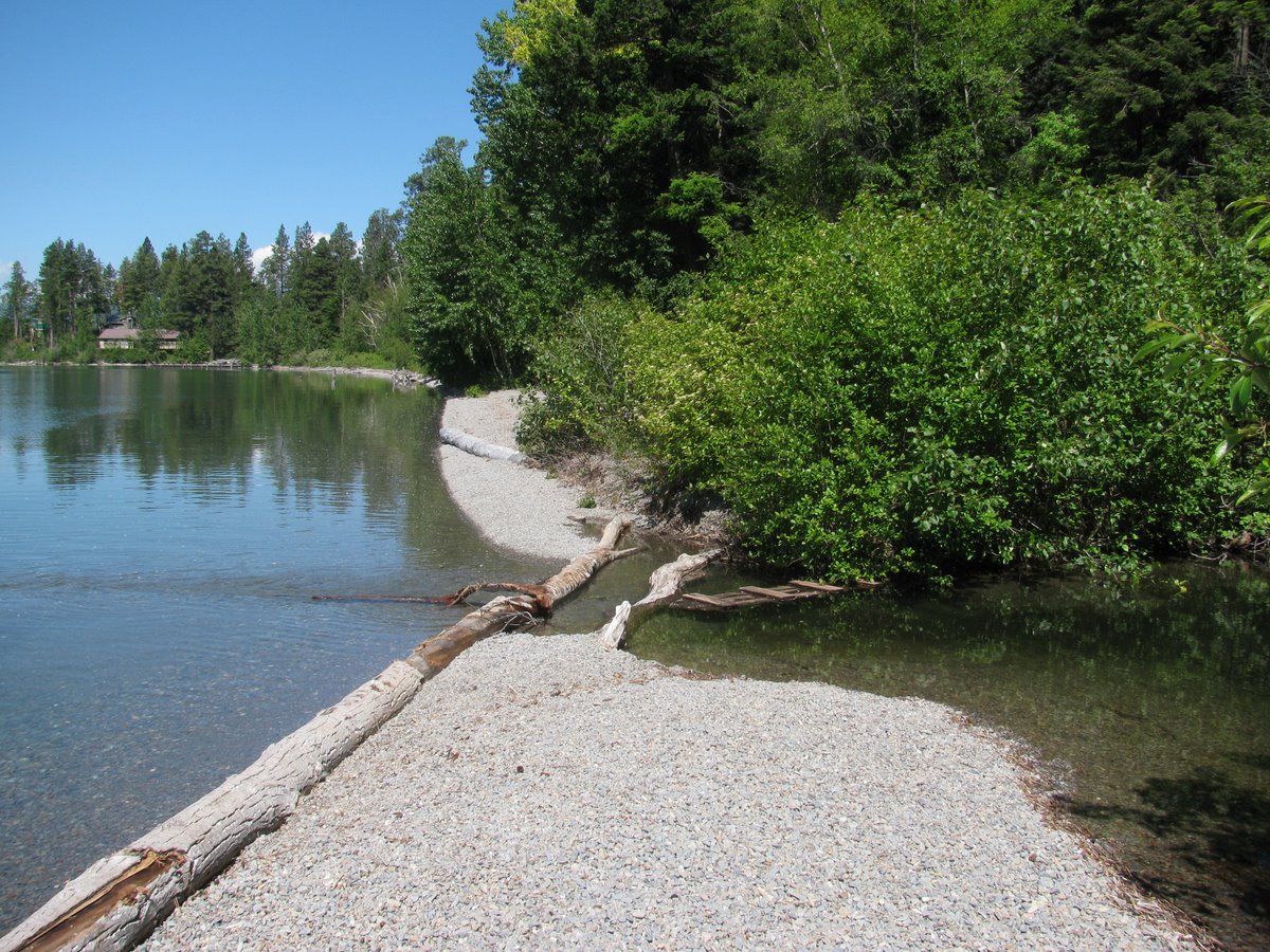
 Along the southeast side of the lake, however, small beaches occur in association with minor bumps on the shoreline. Some may correspond to small stream deltas, but not all do. This is based on very limited observations, but the shoreline between these points appears to be sediment poor. These photos are from one of these small points, where the beach has formed a small cusp at one of these subtle promontories.
Based on some Puget Sound examples, I suspect this may reflect a tendency of promontories on shorelines with highly oblique wave action to act as attractors for sediment (this is related to work done in the last decade by Ashton, Murray, and others, too). This contrasts with the classic coastal model which suggests that headlands should erode and sediment should accumulate in the areas in between. Those examples make sense on ocean coasts with big waves where incidence is more normal to the shore.
In Glacier, most of the beaches consist of green and red pebbles eroded from the Precambrian sedimentary rocks of the Belt Formation.
Saint Mary Lake, on the east side of Glacier National Park, has some neat beaches. Unfortunately, I didn't actually get very close to them on this trip, but that isn't stopping me from writing this post.
When I was a kid, our family had to beach our rental canoe when the winds coming down the lake prevented our rounding the point to get back to the boat launch at Rising Sun. That beach, a narrow gravel berm littered with drift wood, was just below the classic Goose Island turnoff on the Going to the Sun Road (the barrier beach is barely visible in the middle photo).
Two opposing promontories form the Narrows of Saint Mary Lake. The westerly winds that have blown down the lake for thousands of years have built swash aligned beaches on the western shores of each of these points (AERIAL VIEW). The one on the north shore is the one where I was shipwrecked as a child. The larger and more interesting beach is a beautiful barrier on the southern shore (see top photo). The best way to explore it, short of a long hike, would be by canoe or kayak and with a a big can of bear spray.
 If you explore the lake with the aerial imagery, you'll find other interesting beaches, too. There are some neat beaches spreading downdrift from a stream delta on the southern shore (AERIAL). And more along the toe of the alluvial fan that forms the southeastern end of the lake (AERIAL).
15,000 years ago, Missoula was underwater. Something like 40 times. And each time the ice dam would break and the water would race across Idaho and Washington and out the Columbia Gorge to the Pacific. But between dam breaks, the lake carved shorelines into the hills above the University.
Saturday morning (September 2nd) I hiked up to the "M" on Mount Sentinel, which provided great views of the strand lines across the way on Mount Jumbo. They show up well in the low light - but are pretty subtle when you're actually climbing across them.
Lake Bonneville (July 2007)