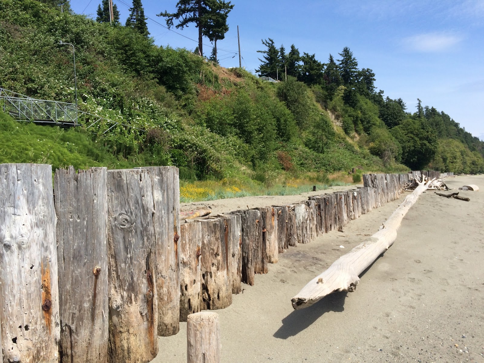
Here's a nice example of a small beach project that almost no one knows about. It's an artificial gravel beach at a hard-to-find public access on Everett's industrial waterfront. The initial project was done in conjunction with an outfall in the very early 2000s and then was revisited a few years ago.
AERIAL VIEW
The beach lies in a corner created by the railroad grade and the large projecting fill associated with the Port of Everett. While the orientation is favorable to maintain some sort of beach, they've had problems here maintaining a sustainable profile. I suspect they need smaller gravel and more room - the latter of which may simply not be possible on this site. It's not just the geometry of the upland, but also the proximity of Pigeon Creek, which would be a constant sink for sediment were the beach to extend much farther west.
I actually think there's a nice location for another beach just around the corner to the north - maybe toss in a few thousand cubic yards of sandy gravel and let it sort itself out.
Showing posts with label snohomish. Show all posts
Wednesday, August 08, 2018
Tuesday, July 19, 2016
Edmonds
AERIAL VIEW
But Edmonds has managed to keep its beaches, and better yet, managed to make them the centerpieces of its public waterfront. Brackett's Landing North, north of the ferry, is a Wolf Bauer project from the 1980s, although the city did some additional work on the backshore, the bulkhead and the walkway following a big storm in the mid-1990s.
Edmonds: February 2014
Brackett's Landing North: April 2009
Edmonds: April 2009
Labels:
puget sound,
salish sea,
snohomish,
washington
Location:
Edmonds, WA, USA
Monday, May 09, 2016
Edgewater Beach
Before 2005, this was an out of the way spot where a lot of folks came to run their dogs on the beach. There was a dirt parking lot behind an eroding bank, and a small pocket beach tucked into the corner formed by the eastern end of the old tank farm.
Then the Port of Everett built the Mount Baker Terminal, primarily to move large airplane parts up the hill to Boeing's plant at Paine Field. Mitigation for the pier included improvements to the beach, but until the last year or so it was still sort of hard to get down here. Now the park is open and there were dogs out running on the beach again.
AERIAL VIEW
There are really three parts to this beach. There is the western corner where the beach was before. The orientation doesn't really lend itself to stability and it tends to unravel (just as it did prior to the pier), causing erosion along its back edge and leaving a beach covered with smaller riprap and quarry spalls shed from the adjacent riprap. Sediment eroded from this beach ends up on the low tide terrace, with help from the streams under the pier.
The beach farther east stretches out for 1000' along the railroad grade and has done well. It's probably eroded back a little, but there's a nice berm, plenty of logs, and a heavily vegetated backshore where once there was just a towering seawall and no beach at high tide.
Much of the sediment lost from this beach has simply spread out farther along the train tracks, which is exactly what was hoped for in the first place.
This was an expensive project and we may need some cheaper approaches, but it's an important demonstration of how we might eventually restore a lot more of the Great Northern Beach between Golden Gardens and Everett.
Labels:
puget sound,
restoration,
salish sea,
snohomish,
washington
Location:
Mukilteo, WA, USA
Sunday, May 08, 2016
Mukilteo
AERIAL VIEW
The edge is still pretty ragged. I don't mind the buttress of the old pier, but the riprap is a mess (it could probably be steeper and neater, leaving a much nicer beach) and there's an awful lot of asphalt rubble and old plumbing still left. It's pretty common after a structure on the beach is demolished for old debris to keep reemerging - something to keep after.
(There's another ugly section of shoreline farther west, in front of the NMFS Research Station, but I'll keep my fingers crossed that they have a plan to clean that up someday, too!)
I'm looking forward to this beach in a few years, after the ferry terminal is done. It seems like there is an opportunity to create a wonderful beach experience all the way from the old ferry terminal to Edgewater Beach (next post) - the only place the beach really vanishes is at the new ferry terminal itself, but the designs show some sort of walkway above the riprap and through the building.
Mukilteo Multimodal Project
The offset in the shoreline where the old pier was located will be difficult to navigate on the beach -- at least at higher tides - but with some imaginative design work, I think this segment could be made much better.
For a great view of the old pier, check out this drone video:
Mukilteo Government Pier (Kevin S)
Labels:
puget sound,
restoration,
salish sea,
snohomish,
washington
Location:
Snohomish County, WA, USA
Sunday, August 02, 2015
Lund's Gulch
Meadowdale is one of the several small parks that sit on stream mouths along the railroad between Seattle and Everett. I like to call this stretch the Great Northern Beach, after the railroad that shaped this coastline for so much of the 20th century and which continues today as the BNSF.
Spits are common at the mouths of coastal streams and the one here has been growing the last few years, extending north and then pushing the stream outlet into a narrow channel. These spits tend to grow for a few years, get cut off by the erosion associated with a big stream flood or a big coastal storm, and then do it all over again.
AERIAL VIEW
The creek that flows through Lund's Gulch is one of thousands of small streams that empty into Puget Sound. Very few remain in their natural condition and even in remote parts of the Sound we find that their lower sections have been rechanneled, their estuaries filled, and their mouths funneled through culverts beneath roads and railroads.
This stream drains a small watershed surrounded by dense residential development. The valley itself seems to be in pretty good shape, but generates a lot of sediment, all of which must find its way to the mouth. Unfortunately, the stream's last leg is through a small concrete box culvert that must pass high flows, sediment, fish, and pedestrians - and it can't do these all at the same time.
There is no simple way to enlarge the opening beneath the rails. This problem is shared with many other stream mouths around the Sound and I've always wished their was some strategic approach that could be applied to a suite of these sites - an approach that would fix the stream mouths, improve conditions for fish, and also help improve safe public access to the beach along this dense urban corridor.
Some other stream mouths along the Great Northern Beach:
Carkeek Park (2009)
Boeing Creek (2013)
Picnic Point (2007)
Merrill and Ring (2009)
Howarth Park (2011)
And elsewhere:
Sequalitchew Creek (2010) (on another section of the railroad)
Nellita Creek (2010, 2011)
Seahurst (2009)
Glendale (2009)
Eglon (2007)
![]() |
| Brand new sand bar right at the stream mouth |
Labels:
puget sound,
restoration,
salish sea,
snohomish,
washington
Location:
Picnic Point-North Lynnwood, WA, USA
Monday, July 06, 2015
Mission Beach
Mission Beach, on the Tulalip Reservation, is a heavily developed stretch of shoreline, with homes built out over the beach and perched on top of the bank. It's a continuous (albeit colorful) line of stairways, boat lifts, and timber bulkheads.
I visited several years ago (see photo and link below) and this stretch at the south end was a long row of homes tucked into the toe of an unstable bluff. Storm waves could be tossing logs against the front windows while mud from the hillslope flowed in the back door.
AERIAL VIEW
These properties were all leased from the tribe and the tribe decided a long time ago that when the leases ran out, they would reclaim the beach. And in 2013, that's exactly what happened. I'm sure that no amount of warning makes someone feel good about dismantling something that's been part of their family's lives for decades, but it's also a neat reminder that nothing is forever (or at least that some things, like beach houses below unstable slopes, should be forever). It would be nice if the remaining pile bulkhead could be pulled - it provides little, if any, benefit and prevents complete restoration of the beach.
Everett Herald: February 2013
Here's what this same stretch looked like in 2009 (from Mission Beach 2009)
Labels:
puget sound,
restoration,
salish sea,
snohomish,
washington
Location:
Shaker Church, WA 98271, USA
Monday, March 09, 2015
Oso
I've noted before that I try to keep this blog pretty focused - on beaches. Or maybe shorelines in general. Or maybe on geology. This is mainly in that last category, although there's not actually much geology in this post.
We were in New Mexico last year when I heard someone ahead of me in line ask the clerk if they'd heard about the big landslide up in Washington. Some quick work on the internet confirmed where it was. I guess I had heard other geologists mention the "Hazel" slide after the 2006 event, but knew little more about it than that. The field trip at last week's AEG workshop on landslides was my first chance to visit the slide and it was great to be able to do it in the company of people who know a lot about geology and landslides.
The Oso landslide occurred on March 22, 2014, on a Saturday morning when pretty much everyone in Steelhead Haven was at home. The hillside collapsed - on the site of an old, recurring slide - and ran out across the entire valley floor. Subsequently, geologists have begun to uncover evidence that this section of the North Fork of the Stillaguamish River has seen this kind of event before - although like earthquakes, they do not occur often and there is probably little way to predict just when and where they'll occur. And when they're not occurring, these are very attractive places to live.
Engineers and lawyers and government agencies will be debating the details for years, but I guess my takeaway was that the more we know the better, but that we can never know everything as well as we might want. Especially in hindsight. High bluffs and barrier beaches and floodplains are created and maintained by natural disasters. That doesn't mean we can't build on them, but maybe as a society we have to do more to educate ourselves about the risks.
Two miles downstream, you wouldn't know what happened less than a year ago.
Labels:
snohomish,
washington
Location:
Snohomish County, WA, USA
Wednesday, February 19, 2014
Edmonds
I have this peculiar little hang up. If you're going to spend all day in a meeting or a workshop about beach stuff, and it's held within a stone's throw of the beach, you should actually go to the beach. Even if it's only for five or ten minutes early in the morning and there's a high tide and a bitterly cold north wind.
AERIAL VIEW
And here are a couple of earlier posts from April 2009, when it wasn't quite so cold as this Monday morning two weeks ago.
- Edmonds
Labels:
puget sound,
salish sea,
snohomish,
washington
Location:
Edmonds, WA, USA
Friday, May 11, 2012
Woodway Beach
There's not much beach left below Woodway - the upscale bluff-top community just south of Edmonds. Once upon a time, this would have been a wonderful beach walk from Edmonds south through Woodway to Point Wells at all but the highest tides, but in the late 1800s the railroad chose the beach at the toe of the bluff as its route between Seattle and Everett and the beach got narrower.
Unfortunately, the bluffs along this stretch continued to fail magnificently long after the waves stopped cutting at their base, and landslides and busy rail corridors don't mix well. In the 1950s, Great Northern, faced with the high costs of keeping the Empire Builder out of Puget Sound, relocated the entire line away from the bottom of the cliff. The result was a long linear lagoon between the old grade at the bluff and the new causeway on the lower beach. The beachface has become a lagoon. Large slides in the 1970s filled portions of this trough, as did the 1997 Woodway landslide near Deer Creek.
Burlington Northern Santa Fe - the inheritor of the Great Northern - plans to eventually complete double tracking of this corridor (all the better to hall Powder River coal to Bellingham? - 2011 Wyoming, 2012 Black Thunder Mine). Meanwhile, the local police are kept busy enforcing BNSF's No Trespassing signs - shooing away teenagers trying to navigate Woodway Beach at high tide.
AERIAL VIEW
Labels:
puget sound,
salish sea,
snohomish,
washington
Location:
Woodway, WA
Monday, May 09, 2011
Howarth Park
The railroad and the high bluffs make access to the beach between Seattle and Everett a tricky proposition, but there are places where stream valleys, pedestrian overpasses, and public parks conspire to make it possible - Carkeek Park, Picnic Point, and Howarth Park, for example.
The natural stream mouth at Howarth is obscured beneath the railroad grade and the big pile of dirt that surrounds the stair tower -- the creek tumbles out of a long culvert onto the riprap. From the look of the wetland next to the parking lot, this stream might have had a sufficiently low gradient to result in a nice little estuary (probably behind a small spit - sort of like the one down the beach at Merrill and Ring Creek).
Labels:
everett,
puget sound,
restoration,
salish sea,
snohomish,
washington
Sunday, October 17, 2010
Jetty Island
Saturday afternoon I took the kayak up to Everett and paddled across to Jetty Island. In the summer, the City runs a ferry over to the island and the main beach on the west side fills up with people enjoying the warm (relatively) water flooding in over the broad sand flats, but on this trip I had the whole place to myself.
The tide was high, so there wasn't much beach to walk on (and the upland portion of the island, at least the north end, is North America's densest thicket of Himalayan blackberry). I walked up to the northeastern tip of the island,
which was littered with remnants of old structures and lots of big wood, washed down the river and stranded on the beach. Then I wandered back to the main beach, the spit, and the lagoon.
Everett is located just south of the mouth of the Snohomish River (as was the historic Tulalip community of Hibulb, long before Everett Colby's father founded the city). The shallow subtidal foredelta of the river extends out into Port Gardner, making deep water access difficult, so a century ago, a jetty (training structure or breakwater?) was constructed to channel the main stem of the river southward along the waterfront (see the aerial photo linked to the title of this post). Dredged sand was placed on the western side of this structure and gradually a new island was built. In 1989, the Port of Everett used the dredged material to create an artificial berm - basically a spit, that in turn formed a large tidal lagoon.
Jetty Island is a Puget Sound anomaly. It is all sand, river sand, unlike most of our gravelly beaches, which get their sediment from eroding bluffs and small, steep streams. It is completely artificial - this entire area was shallow sand flats historically. And it is the largest beach nourishment project on the Sound and the only one built from dredged river sand. It is a frequently cited example (particularly by the Corps) of beneficial use (of dredged sediment).
Some folks note that the ecological picture painted at Jetty Island isn't really true restoration (they're right). Others seem more put off by the blackberries and invasive species than they are impressed by the salt marsh and the birds. And some people are just leery of pretty much everything the Corps of Engineers does (not an unwarranted skepticism). But ultimately, this is a pretty neat place. Maybe they ought to build something like this outboard of the Shilshole breakwater or along a section of the railroad grade!
Labels:
everett,
puget sound,
restoration,
salish sea,
snohomish,
washington
Subscribe to:
Posts (Atom)


.jpg)