skip to main |
skip to sidebar

Hug Point is a small rocky headland that extends out across the beach a few miles south of Cannon Beach. The rocks include both Tertiary sediments and an intrusion of Columbia River basalt. 100 years ago, travel along the coast generally used the beach, but at Hug Point, a road was carved into the promontory (the old roadbed doesn't show in these photos).
AERIAL VIEW
Fall Creek arrives at the beach over an 8' waterfall. As streams often do on these kinds of beaches, it exposed the coarse cobble that underlies the upper part of the more ephemeral sandy beach.

Cannon Beach extends south from Tillamook Head and Ecoloa State Park. It's best known, visually and geologically, for Haystack Rock, a very large sea stack located just offshore, yet still accessible during low tides. Haystack Rock is Columbia River basalt, extruded into the surrounding sediments as the flows reached the former coast and then subsequently exposed by erosion.
AERIAL VIEW
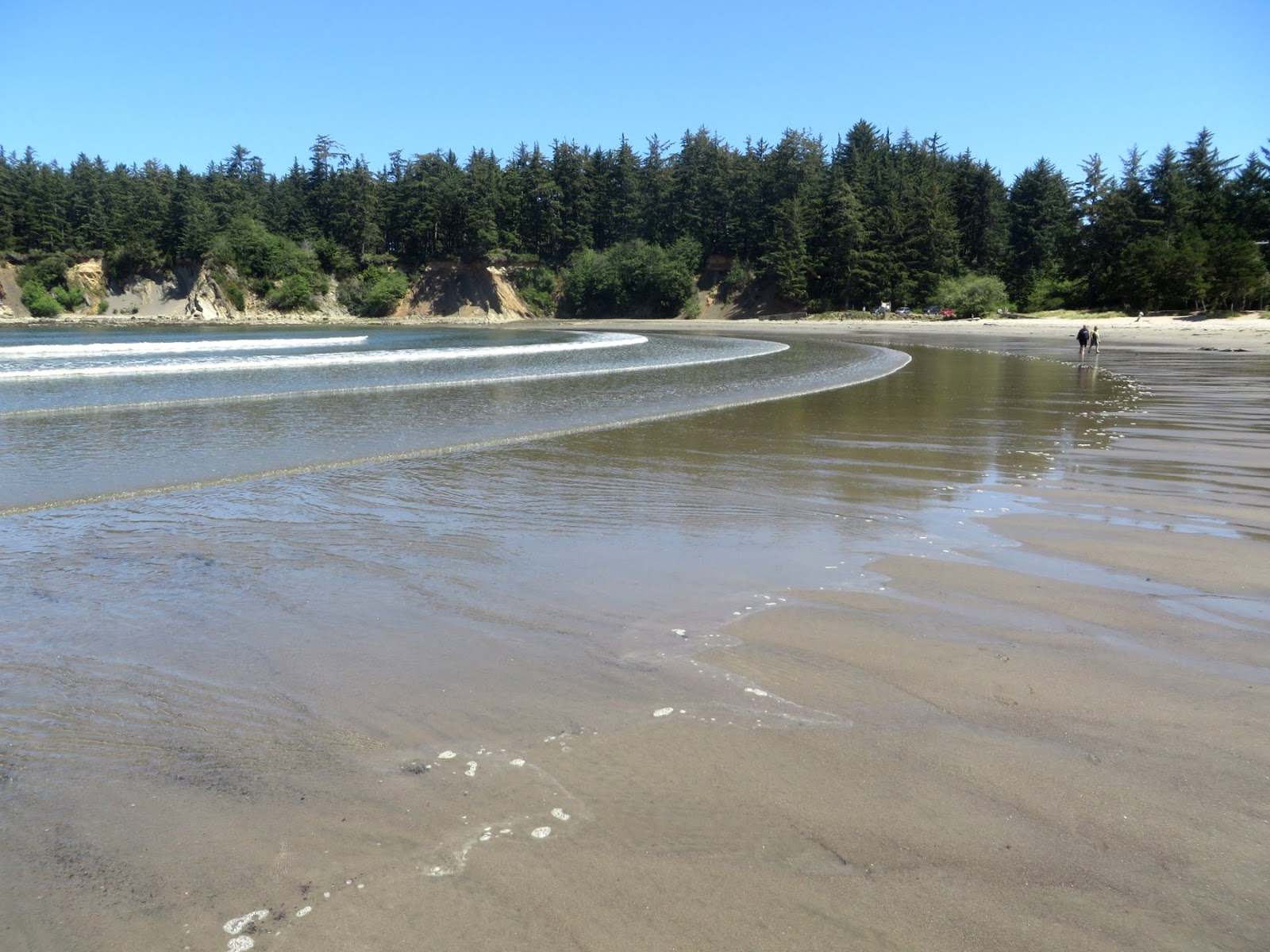
Cannon Beach seems to be several communities stretched out along the shore. The northern end is very low - a barrier beach associated with the mouth of Ecola Creek. But much of the rest of the town to the south lies on somewhat higher ground behind a modest bluff, although I'm not sure if this is a marine terrace or just old dunes.
Indian Beach, in Ecola State Park, is a two kilometer long pocket beach tucked into the southern side of Tillamook Head. The upper beach is a very steep coarse gravel and cobble berm - the lower beach is flat and sandy.
AERIAL VIEW
A small stream empties out onto the northwest end of the beach. And a landslide (or several landslides) empty out onto the other end of the beach. The cliffs that rise behind the beach is Columbia River Basalt that flowed out to the coast 15 million years ago, before the modern coast range was established.
South of Seaside, the wide sandy beach runs into the rocky headland of Tillamook Head, which projects westward into the Pacific. But even this northern edge of the headland has a beach, it's just a very different one. The lower beach is rounded boulders and the upper beach is a coarse gravel and cobble berm. I assume this coarse material is all basalt, eroded from the promontory and spread eastward along it's northern shore.
AERIAL VIEW
The westerly swell sweeps along this shoreline, breaking at a very sharp angle and creating (at least under the right conditions) a strong left break just offshore. Seaside Point is a beach with a guarded, but apparently well-deserved, local reputation. During our visit, the waves seemed a little choppy and chaotic (surfers probably have a better vocabulary), but there were still a lot of surfers in the water. A strong rip develops right along the beach, making it easier for them to paddle out, but also creating a bit of a hazard.
I think the little divot in the corner (where the headland meets the main beach) is what is referred to as "the cove." The cobble beach takes an inland excursion (see aerial), leaving a sandy pocket - makes an easier entry for the surf crowd then stepping through the boulders farther out. Interestingly the cobble then continues a little farther north until it is overwhelmed by the sand (see previous post). I was curious about the origin of the cove (it's more complicated than simply being an inside corner between the north-south sandy beach and the east-west cobble beach), but so far my ideas are pretty speculative (even more speculative than usual).
The main beach in Seaside is broad and sandy, with a wide band of low grassy dunes between the promenade and the beach - enough to keep storm waves out of town, but not enough to shelter the town from a significant tsunami. The plate boundary is not far offshore - twenty minutes would be barely enough time to get to high ground under the best of conditions.
AERIAL VIEW
Seaside lies just north of Tillamook Head, at the south end of the Clatsop Dunes. This segment of beach, from Seaside north to the Columbia River is a sub-cell of the larger Columbia River cell and most of the sand on these beaches came out of the Columbia River. The other three sub-cells all lie north of the river mouth, in Washington.
The flat sandy beach in these photos is a big contrast with the cobble beaches at the very south end which I'll describe in the next post. But as you walk south - to the vicinity of "U" Avenue - a cobble berm begins to assert itself.
 Originally, I just pulled off the road to admire the sea stacks south of Cape Sebastian, but I wound up wandering the beach for half an hour, exploring the dunes (my copilot seems content with the view from the car and a good novel). The back beach was a field of crescentic, 1.5-meter high dunes, charged by a brisk wind from the north.
 There was a lot of sand moving - although almost all of it below ankle level. It blew off the top of the dunes and settled on the slip face. Eventually, the slope would avalanche - sometimes all at once (as if all of those individual grains were in communication with one another) and sometimes as a progressive failure, usually, but not always, starting at the bottom.
The dunes were moving across a deflated surface - the flat roughs were largely bare of sand but often exhibited some neat eolian erosion features.
AERIAL VIEW

The theme of this post is sea stacks (or seastacks). From Cape Arago north, the terrace has been composed of Tertiary sedimentary rocks, but moving south we encounter Jurassic metamorphics at the coast. Here in Bandon, they are scattered across a beautiful broad sandy beach.
Sea stacks are simply the leftover bits of a receding coastline. They can occur on any rocky shoreline, but I suppose they are more common in places where geologic differences allow some areas to erode much more easily than others.
This can happen in heavily jointed or fractured areas, but it can also occur where chunks of more resistant lithology are surrounded by softer rocks. In California, this can occur when resistant blocks of Franciscan form knockers that get left behind. Or in other places where volcanic rocks are surrounded by more erodible sediments. You can probably get stacks even in uniform geology, but it seems like it would be less likely.
I have no idea what controls the formation of these particular stacks - differences in lithology within the metamorphic rocks?
AERIAL VIEW
Another interesting observation about this area. Komar and colleagues observed in the 1990s that slower cliff erosion rates in this area (evidence includes gentle vegetated slopes and intact talus) was consistent with modern uplift along this shoreline, which tends to reduce wave action at the toe.
Cape Arago is the tip of the broad headland southwest of Coos Bay - the same headland on which Sunset Bay and Shore Acres (previous posts) are located. The viewpoint offered great views down the coast - complete with whales - but it was the beach right below us that caught my attention.
AERIAL VIEW
I scrambled down to the little cove (Middle Cove) on the south side. The trail came down across what looked like an old landslide, perhaps a source of sediment for the isolated beach at the bottom. The beach itself is fairly protected by the headland and by offshore rocks, but the exposure to the south is still pretty significant and there must be enough wave energy to stack up those big cobbles!
But it's awfully hard to picture winter storms on a sunny, calm June day.
More photos of the marine terrace. More steeply dipping sedimentary rocks planed flat on top by waves 80,000 years ago and then subsequently covered by a thin layer of beach and dune deposits. Then gradually lifted 80-100' by plate tectonics and, much more recently, carved into seacliffs and sea stacks.
Sunset Bay is cut into a thick section of steeply-tilted sedimentary rocks. This geologic structure is exposed in the cliffs that surround the bay as well as in the strike of resistant layers on the eroded platform, but it is also seen nicely in the aerial images, as all of the headlands and islands follow the strike of the rocks.
AERIAL VIEW
There's a nice sandy pocket beach tucked into the bay. It's protected from the worst of the open ocean by the shape of the bay and the rocks that guard its entrance, but smaller waves spread out regularly across the flat low tide terrace.
The roots of large spruce? trees appear on the lower beach on the south side of the bay near the mouth of Big Creek (not the same Big Creek as the previous post). Since these trees would not have grown in the lower intertidal, there must have been significant subsidence here. At the same time, the marine terrace that is visible on the adjacent uplands suggests long-term uplift. Or at least net uplift. These subducting coasts ratchet their way upwards, the long-term pattern punctuated by abrupt subsidence in large earthquakes every few hundred years.
I spent half an hour exploring the beach between the mouth of Big Creek and the much smaller creek at the Muriel Ponsler Wayside, a few miles north of Heceta Head.
The smaller creek emerges from a narrow ravine cut into the terrace (more later) and spreads out on the upper beach before cutting through a broad sand bar and escaping to the sea. Streams flowing across beaches are as instructive as they are ephemeral. This one exposed a cobbly substrate below several inches of beach sand. The northerly wind was causing small dunes to cascade down the north bank of the stream. The stream channel was carving a steep cliff into the south bank. There were terraces and braided channels and small deltas. But it will all be erased and completely rebuilt after the next high tide.
The elevation of the terrace is quite low here, apparently a result of the modest long-term uplift rates on this section of the coast. Highway 101 is built on the terrace, when it's not crossing Big Creek (Big Creek Bridge, for an explanation of bowstring arch bridges and a nice photo of this section of coast).
The modern shoreline has cut a small cliff into the Pleistocene alluvium of the terrace (it looks like the underlying wave-cut platform is below beach level). The cobble storm berm of the modern beach has pushed up against the terrace and modern sand dunes have formed on top.
The wind was blowing from the north, forming small dunes and a lot of other cool eolian features.