skip to main |
skip to sidebar

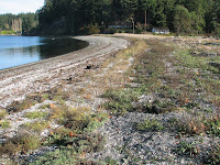
 Like most (practically all, actually) stream mouths on Puget Sound, Big Mission Creek was domesticated early - it's tendency to wander across a small shoreline floodplain and delta held in check by levees, shoreline fills, and other structures. Until last year, an artificial lagoon occupied most of the stream's mouth, but now the small river fans out across a real estuary.
The December storm washed out every creek along southern Hood Canal, including this one. Not that it undid the restoration, but it probably wasted much of the effort that went into the little details. Sometimes the best restoration may result simply from removing the offending structure or constraint and then waiting for a good storm to begin to put things back together (does this sound too much like Edward Abbey?). I guess we want restoration to be as static and predictable as a levee or a seawall, but ultimately restoration is about allowing the uncertainty and the storms and the floods back in.


 The bluffs between Point Partridge (OCT2006,FEB2006) and Ebey's Landing consist of a thick pile of gravel left by the retreating glaciers. The lack of cohesive sediments, complex stratigraphy, or forest cover result in uniform angle-of-repose slopes that are distinctly different than others on Puget Sound. Net drift is to the southeast - where the gravel eventually winds up in Keystone Harbor, where it must be periodically dredged to allow the ferry to get in. A couple of miles north of Ebey's Landing, the beach splits from the coastline, forming this large lagoon before reconnecting with the bluffs farther south. The result, with help from the National Park Service and the Nature Conservancy, is a 3+ mile loop that is the best shoreline hike on Puget Sound.
The gentle waves breaking on the beach today were about 10 seconds apart, suggesting they began as much bigger waves out on the Pacific. Occasionally a big storm comes over spit, recharging the lagoon and creating gravel washover fans on the backside of the barrier.

 Two years ago, Sound Waters coincided with the big storm. I requested wind and waves again this year, but I guess the organizers were too busy to make this a priority. I took the long way home, swinging by Ebey's Landing which is just a couple of miles across the prairie from Coupeville. It was crowded with beach walkers on this slightly overcast Saturday afternoon.

 The northern shore of Point Wilson is looking pretty ragged. A legacy of defensive actions and good intentions have segmented a once continuous beach and dunes into a fraying edge of rocky headlands and eroding pockets. Riprap protecting battery Kinzie, three (sometimes only two are visible) mismatched groins built in the 1980s, and the rock fortress around the northern side of the lighthouse, have mucked up natural sediment transport patterns along the beach and between the beach and the dunes. I suspect this beach is far less resilient to future erosion and rising sea levels than in its original condition. Point Wilson could use some serious rethinking! It will require looking at the whole point, not just the lighthouse or the parking lot.
 Also from November. Battle Point is a neat little cuspate spit and lagoon on the western side of Bainbridge Island. The inlet is on the south shore, while the northern limb shows some signs of continued accretion. Note the newer berm in the upper photo. Erosion of the inlet exposes peat from an earlier incarnation of the lagoon and marsh.


 After Friday's site visits were postponed, I decided it was time to post a few retrospectives from earlier in the fall. Sadly, I haven't been getting to the beach much the last few months. This is from October 11th, taking the long route back from teaching a Beach Watchers class on Whidbey.
The rock and concrete on the spit suggest a complicated history - like other spits, large and small (Ediz, Semiahmoo, Shaw's Cove), concern about breaching leads to armoring of the narrowest part of the spit, which may only make things worse. Spits are typically most vulnerable near their bases. Unlike the distal ends, where sediment accumulates to form broad berms, these narrow approaches are just transport corridors and are susceptible to big storms and small changes in sediment supply. Most are probably migrating. Armoring just forces the beach to become narrower and prevents overwash from maintaining the backbone of the spit. Pull the rock off the spit, add some gravel to compensate for decades of neglect, and allow the spit to shift north a little bit.
Ala Spit (sometimes called Ben Ure Spit) is probably not helped by the seawall, fill, and rock groin immediately south, which muck up sediment transport and may simply be encouraging growth of a gravelbars at the expense of the current spit.


 Dabob Bay is one of those few remaining places on Puget Sound where the forest still seems to dominate the landscape. There are homes and a few oyster operations, and the forest is certainly not original, but there's something special here that's been lost in other places.
We walked down to Broad Spit through fog, drizzle, ferns, and big trees (and bigger stumps). The recurved spit is fed from the bluffs to south and shelters a small lagoon. The shore is littered with the remains of decaying timber oyster? rafts.
Both here and later, when out at North and South spits (farther north into Tarboo Bay), there were hints that maybe the spits had evolved over time. Spits form, but as sediment accumulates and the shape of the shoreline changes, new spits form. At Broad Spit, this may have allowed a small spit or spits to form on the north side, in the lee of the main spit. At the northern location, it looks like North Spit formed first and South Spit formed later, relegating the former to relic status.
We didn't get over to Long Spit, on the east side of the bay, nor to the spectacular bluffs and landslides that feed it. Maybe next trip - maybe from a boat on a sunny day?


