Showing posts sorted by relevance for query discovery park. Sort by date Show all posts

Sunday, July 07, 2013

Discovery Park


The south side of Discovery Park shares the same deep-seated landslide complex that characterizes most of the southwest shore of Magnolia - the difference here being that the slide is sort of doing what it always did, whereas elsewhere in Magnolia, great efforts have been taken to stabilize the slope enough to build homes on top of it.

But here in the Park, we get a glimpse of a big landslide in action. The slope is sliding on clay at, or slightly below beach level.  This is a common scenario for these deep slides and the symptoms are often similar.


Previous Posts:

Discovery Park: February 2010
West Point: February 2012


The beach (way out onto the terrace) is a mosaic of subtle ridges of cobble and clay, likely artifacts of past movement on the slide as the coastline has retreated.  Although there are some intact outcrops of clay on the beach, most show signs of uplift, tilting, internal deformation, and a general tendency towards soft and gooey. 


The eroding bluff at the toe of the slide consists of sandier material and large wood that has been incorporated into the slide mass as it has gradually moved towards the beach.


Wednesday, November 28, 2012

Camano Island State Park


The best use for a big deep-seated landslide on Puget Sound is probably a forest.  The next best use may be a relatively low-intensity public park.  The northern day-use area at Camano Island State Park sits on a mid-slope bench, the contents of which began their jerky movement to the Sound hundreds or thousands of years ago.  The uneven surface of the picnic area and the offsets in the parking lot suggest nothing has changed.

The head scarp is a high steep, forested slope that rises above the parking lot.  Big drain pipes convey water from the land above (part of which is the park entrance road, but other parts of which are private homes) down to the bench, where hopefully it then gets captured and sent to the beach.  Water is, after all, the grease on which these slides move, and the simplest way to slow their movement is to keep the water out.  Of course, even that may be far from simple.  The bench often slopes landward, making natural drainage tough, and slide movement can break pipes or otherwise disrupt drainage.  And often the water is deeper groundwater, which doesn't lend itself to easy solutions.

These big slides often have portions that are more susceptible to movement than others - often, but not always, due to past or present drainage problems.  The most active portion of this slide is the outside lane of the road down the bluff -- if it expands, access to the day-use area may become a lot more difficult.  Or a lot more expensive.

But again, better a park.  All too often, developers covet these benches for rows of million-dollar homes, and the developer is long gone by the time the foundations start cracking and the septic tank slides past the patio.

AERIAL VIEW

Other Big Landslides:
Perkins Lane, Seattle
Ledgewood Beach, Whidbey Island
Camano Head, Camano Island
Discovery Park, Seattle
Kopachuck State Park, Gig Harbor
Turnagain Heights, Anchorage
Termination Point, Hood Canal


Saturday, February 25, 2012

Wolf Bauer


West Point 2004


Golden Gardens 2011


Seacrest 2011


Brackett's Landing 2009


Ambleside 2011

Tolmie 2009


West Point 2010
Birch Bay 2010 
24 February 2012

Wolf,
As you begin your second century, I wanted to remind you of what an amazing difference you have made for Puget Sound shorelines and for the people who visit them.

You were instrumental in raising awareness of shorelines and in creating a demand for shoreline protection.  Today, it’s easy to take our beautiful beaches for granted, but without the amazing efforts of you and others in the early 1970s, this place would be a very unattractive place.  Your language and your ideas have remained lasting elements of Shoreline Master Programs across the state.


You described accretion beaches as an endangered species.  At the time, you may have doubted our progress, and it’s true that we have lost some special places.  But thanks to your work, many remain intact and more are becoming public. 
Lily Point on Point Roberts is now a county park.

In the 1980s you spoke adamantly of the need to restore our urban beaches and to enhance the public’s shoreline experience.  But you did not just talk about it, you gave us examples.  Today, we have examples everywhere: in Seattle, Tacoma, Bremerton, and elsewhere.  And there are a new generation of projects such as the Sculpture Park Beach in Seattle and Marine Park in Fairhaven that were inspired by your example and carried out by impassioned individuals who had learned from you.


People enjoy our most spectacular urban beaches, yet many do not realize that these places were once buried in riprap and would be still were it not for your efforts.  People love the beaches at Discovery Park, Golden Gardens, Birch Bay, West Vancouver, and Tolmie State Park.  They think these places have always been this nice!


This year, we are mapping feeder bluffs throughout the Sound – the feeder bluffs that you taught us were such a critical element of the shore-process corridor.  Also this year, I was approached about what to do about salt marshes choked with cut logs from decades of sloppy log-rafting practices.  I jumped at the chance to share your presentation on this subject from almost two decades ago.


Increasingly, parks managers and and government regulators and fish biologists are looking for opportunities to restore beaches and to put sediment back into the system, not lock it away behind walls of rock.  People still build bulkheads, but doing so is widely discouraged and is increasingly difficult. In some places we are actually pulling seawalls off the beach and removing riprap from our spits.


Your legacy runs deep on Puget Sound and our shorelines are far, far better places today than they ever would have been without your incredible passion and your tireless commitment.


Thank you,
Hugh

NOTE:  Wolf turned 100 on February 24th. These photos, most taken recently, are all nourished beaches designed by Wolf in the 1970s and 1980s. Their captions link (in most cases) to previous posts on those places. Previous Gravel Beach posts mentioning Wolf can be found at:  Bauer Posts.

Saturday, February 06, 2010

Discovery Park


I was just down here in November (
West Point) but the tide had been too high to let me visit the big landslide on the south side of the park. Today, the water was lower and we were able to get a good look at this complicated stretch of shoreline.

There's been plenty of recent sliding - maybe a combination of early fall rains and the recent high tides. The beach was littered with scraps of wood and there was little logic or pattern to the sediment on the upper beach - suggesting lots of fresh material, lots of sorting still to happen.
The large central portion of the slide was dumping large amounts of sand onto the beach and a raised band of deformed clay 20-30 feet out on the beach marked the toe of the active slide. The lower beach at the south end of the park is marked by a confused series of ridges or berms. They did not appear to be normal bars - maybe they reflect irregularity in the topography of the platform due to historic deep-seated sliding or otherwise messed up geology.

There was little mobile sediment in this southern area. Maybe it's an an indication of a sediment-starved beach. The historic source of material is the two miles of updrift, and unstable, shoreline now called
Perkins Lane (2007) - which has been largely armored for most of a century.

Thursday, November 12, 2009

West Point


West Point, the western tip of Discovery Park, is arguably Seattle's finest beach (there are others, but each has a very different character). Its north and south beaches converge to form a cuspate foreland that points west from Seattle toward the Olympics. There used to be a tidal lagoon, with an inlet on the north side of the point, where the big treatment plant now sits.

Every beach has a story, or two, but this one has many. Native American history, earthquakes and landslides, tsunamis and subsidence, and the punctuated evolution of a coastal landform. The military showed up and created Fort Lawton, then Seattle showed up with the treatment plant. In 1980, a large sewage lagoon on the south beach was removed along with its enclosing riprap and the beach was nourished with a few tens of thousands of yards of sand and gravel and planted with lots of dune grass. Today, walking the south beach, you might never know any of this (if you ignore the hum in the background of Seattle's waste stream being digested).

I rode my bike down from the park on top (you need a permit to park a car down here) and walked south as far as I could go with today's tide, since the east end of the beach is marked by a large promontory of Pleistocene sediments that have managed somehow to resist the waves and stand like a prow to mid-tide. This is highly unusual on the Sound - suggesting an incredibly durable lithology and/or a more complicated story (which is usually the case, isn't it?)

This place deserves a return trip at a lower tide and with more hours left in the day.

By the way, the instrument tower at the point is a good place to check for wind conditions on the Sound:
Station WPOW1 : West Point

As of this little addendum on Monday evening (11-16-09), air pressure is dropping with another storm coming in -- high winds anticipated
.

Monday, March 25, 2013

Seola Beach


For a shoreline once characterized by eroding coastal bluffs, spilling gravel and sand onto the beach, Seattle has remarkably few of these places left. They exist on the north and south sides of Discovery Park and there is a short stretch on the south edge of Magnolia Bluff. And there is this one elegant bluff left between the developed shorelines of Arroyos Beach and Seola Creek. Elsewhere they've been built on, excavated away, or locked behind seawalls.

Gravel was running in a continuous stream down the bluff while I watched - gradually adding to a talus cone on top of the drift logs.  Next door, the remains of someone's bluff-top backyard perch had landed in a jumble. The views from the homes along Marine View Drive must be spectacular, made more vivid by the excitement of participatory geomorphology.

AERIAL VIEW

The beach south of the Arroyos, all the way down to Seahurst Park in Burien, is marked by a broad sandy low tide terrace.  But to the north, the upper beach becomes coarser and the low tide terrace diminishes - it downright disappears in the vicinity of the previous post where the bathymetry drops off precipitously.  Longshore transport here is to the north (southerly waves dominate along this shoreline), but I suspect it's hard for sand to make it past the Arroyos without getting lost into deep water close to shore.  I wonder if that's why the beaches seem so different to the north?


Wednesday, May 10, 2017

Travis Spit


It's a long, four mile walk on a coarse gravel and cobble beach from Thompson Spit to Travis Spit at the northwestern tip of the Miller Peninsula. The spit extends westward about a mile across the mouth of Sequim Bay - most of the way across, at least.  

AERIAL VIEW

While Travis itself is a fairly simple landform - a classic bay mouth spit - it's part of a complex of barrier beaches that make the story much more interesting. Together Travis and Gibson form paired spits, converging on the mouth of the bay. Gibson is also fairly large, extending south from Port Williams across Washington Harbor, and sheltering a large salt marsh. There's another smaller spit that extends north from the south shore of Washington Harbor. And Paradise Cove Spit is a north-directed spit that has formed just south of the base of Travis Spit on the eastern shore of Sequim Bay. Finally, if you look carefully, you'll see a small secondary spit on the southern side of the distal portion of Travis, with it's own narrow log-choked lagoon. You really need the aerial view and the map for this.


250 meters across the Sequim Bay channel is the site of the old Bugge Cannery (clams), which has been Battelle's Marine Science Laboratory for the last few decades. From the signs, I gather that Battelle may own much of high ground on Travis Spit. The central portion of Travis is narrow, but not so narrow as to show any obvious signs of overwash.


From the tip of Travis, it was a very long walk back to the State Park trail, a not so long walk up the trail to my bike, and then a refreshing ride back to my car. With a quick stop at the Discovery Bay store for chips, I made the 5:30 Kingston Ferry.

For those interested in visiting the Miller Peninsula or Travis Spit, a couple of thoughts. Miller Peninsula State Park is undeveloped, except for a new parking lot off of the Diamond Point Road and a network of trails largely maintained and signed by volunteers. Thompson Spit is best visited by hiking or biking in from the State Park parking lot. Travis would be best visited by parking at Panorama Vista County Park, which is reached off of the East Sequim Bay Road. 


Monday, February 20, 2012

West Point


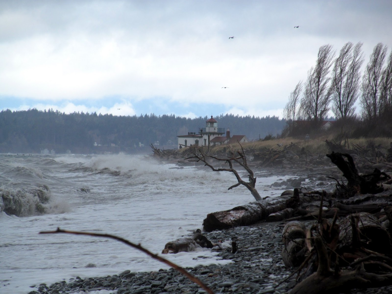
On Saturday afternoon, the north and south shores of West Point were very different places.  A strong south wind was hammering South Beach.  The waves wrapped tightly around the riprap at the lighthouse, rapidly transforming into much more gentle westerly waves breaking along the sandy North Beach.  Well, sandy at least until it vanishes below the enormous rock revetment that cuts off the beach in the vicinity of the old tidal inlet.

The south bluffs in Discovery Park have been active this winter - there was dirt sliding over the Olympia beds from above even as I watched - and it wasn't even raining.  It's interesting to contrast the photo with ones taken two winters ago  (
November 2009; February 2010).  There's also been fresh sliding on the north side where the riprapped spit merges with the bluff, toppling trees and spilling mud onto the beach.


Last year I chose West Point for a photo essay that was posted on the Coastal Care website:
      Coastal Care - Beach of the Month - November 2010

By the way, this is a fantastic website for people interested in understanding and protecting shorelines. The organization has an international scope, highlights a wide range of coastal issues, and hosts hundreds of great photos.


AERIAL VIEW (Google Maps)
Another AERIAL VIEW (Department of Ecology 2006 Aerial Photo)
(I'm not sure yet whether this second link will always work as predicted)

Sunday, July 07, 2013

West Point


At a relatively high tide, walking the beach at West Point below Discovery Park one might be struck by the relief - a steep gravel beach and a much higher and steeper bluff.  But when the tide is 3' below Mean Lower Lowe Water and one walks out to the receding water's edge, the high bluff and the thin strip of gravel sort of fades in the distance.


Previous posts:
November 2009
February 2012

West Point:  Coastal Care -- November 2011

AERIAL VIEW


These broad sand flats south of West Point are spectacular.  Spring time low tides are often an excuse for bus loads of school children to decimate large populations of vulnerable fauna, but really, the best part of these midday spectacles is walking barefoot through sand and eelgrass on gently rolling sand bars. You feel you could almost walk across the Sound - as long as you ignore the fact that the water is almost 1000' deep between here and Bainbridge Island.