Saturday, March 08, 2014

Dockton


Two weeks ago (I hope readers don't think this blog is live - or even almost live), I was on Vashon to give a talk and had a chance to swing by Dockton, where another small restoration project has just happened.  For the "before," check out my post from a few years ago:

Dockton: May 2008

Note that the restoration project is just west of the boat ramp and county park - there is another, larger restoration project just waiting to happen under that parking lot!

The county has recently pulled out the old riprap and excvated an s-shaped channel to capture the upland runoff.  The hydrology may be defined as much by culverts under the road (which lies just uphill) as by the original stream network.  The result is a small stream mouth estuary - or what will become one. Besides the channel, the beach berm has been reshaped to form a small spit.  Waves (what few there are here) and tides will spend a year or two reshaping the berm, but the bulk of the changes from here on out will be in the vegetation and in what ever fauna choose to colonize or pass through.  It will be fun to watch.

AERIAL VIEW


Wednesday, February 19, 2014

Third Beach


We had a pretty benign January, but it seems like the last two weeks has just been one new storm every 24 hours.  Fortunately, many hit hardest at night, leaving us some very pretty days in between the squalls.  Early Sunday morning, I took advantage of a lull in the action to drive out to La Push. Saturday night's storm had subsided and the drive across 101 was beautiful with clear patches and a little sunshine and fresh snow low on the hills.

I was on Third Beach by 11:00. The skies were gray - but dry - and the tide was pretty high, but it was a great dose of the Olympic Coast, which is exactly what I'd come looking for.

Third Beach, like most of the beaches along this coast, is a glorified pocket beach. Its shape is largely defined by rocky headlands - that confine the beaches - and the interaction of Pacific Ocean waves with the complicated bathymetry and clusters of sea stacks - that shapes the beaches. Ultimately, this coastline is probably a reflection of the geology -- an assortment of resistant sedimentary blocks (the headlands and stacks) with much softer stuff in between (the bays and beaches).

AERIAL VIEW


There's a waterfall at the south end - basically a hanging valley where the ocean has cut landward faster than the small stream can cut downward. The waves had cut into a very high sandy berm near the stream mouth - providing some indication of how dynamic this beach must be. Many of bluffs along here are actively collapsing onto the beach. Some appear to be fairly slow-moving slides, but there was a big pile down the beach that looked like it must have come down both quickly and recently.

The tide was too high and the waves too big to explore safely and I look forward to coming back for longer in nice weather and when the tide is out. But it's days like this when stuff actually happens!

By the time I got to Second Beach, an hour or so later, the wind had picked up (the tide, too, there was little beach to be seen). And by the time I got into La Push, the next storm had fully arrived. I ate my sandwich in my car out at the jetty with the wipers on high and the car rocking in the wind. La Push is worthy of a whole post in itself - several, actually - but it will have to wait for a trip where I can get some better pictures.

I drove over to Rialto Beach, but between the storm, the water level, and all those big logs on the move, I decided against walking north to Hole in the Wall. Next time! It was a very wet drive back to Seattle.

Edmonds


I have this peculiar little hang up. If you're going to spend all day in a meeting or a workshop about beach stuff, and it's held within a stone's throw of the beach, you should actually go to the beach.  Even if it's only for five or ten minutes early in the morning and there's a high tide and a bitterly cold north wind.


I like the Edmonds waterfront. I guess that's because despite its developed setting, there are still beaches and most of them are publicly accessible.  It's a far cry from the large spit that once separated a big salt marsh from the Sound (map is from 1872) - the marsh that's left is a small remnant of the original and the barrier is segmented into a few artificially confined pocket beaches - but I wish we could figure out how to do this with some of our other small town waterfronts.

AERIAL VIEW

And here are a couple of earlier posts from April 2009, when it wasn't quite so cold as this Monday morning two weeks ago.


Monday, February 17, 2014

West Beach


I was up in Oak Harbor again for Sound Waters (Saturday, Feb 1st), which meant that I had a few hours in the afternoon to work my way down the island. I spent much of that walking below the bluffs south of Swan Lake, turning around when I got a little south of Fort Nugent Road (which is how about how far I got walking north from Hastie Lake (February 2012) on a comparable Saturday afternoon two years ago).


This is a wonderful stretch of 200-250' bluffs, the bulk of which are sandy units that probably belong to the Whidbey formation (lower) and Vashon advance outwash (upper).  As noted previously, wind erosion is significant along here and the homes along the top are built among the perched dunes where this windblown sand collects. The dunes are largely obliterated by the development, but the sand still collects on decks and driveways.

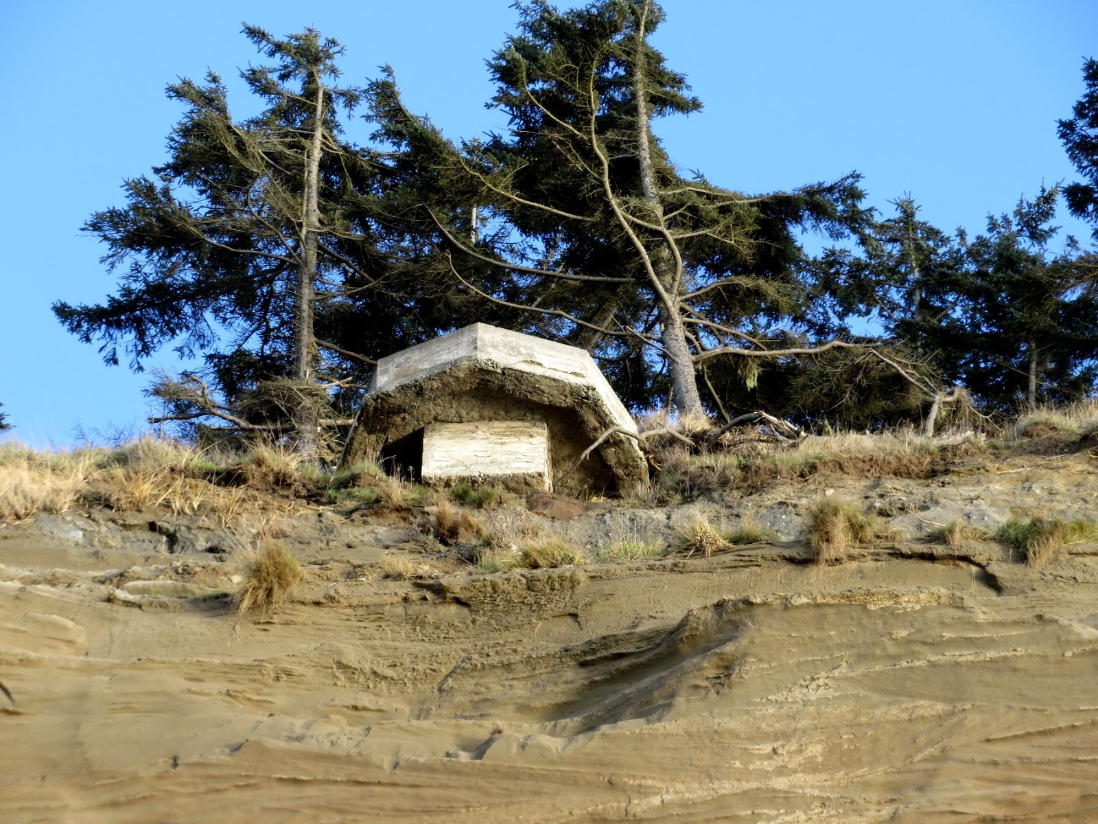
I wish I knew more of the story of these two concrete structures. The one on the beach must have come down fairly recently, although I haven't been down here in a long time so don't know for sure. On Google Earth (image dated 8-25-2011), it is already on the beach. There's another hanging on the edge a short distance north and destined to come down soon.  From their proximity and general similarity, I assume they are a pair - are these observation posts of some sort associated with the island's military history?

AERIAL VIEW

Monday, January 27, 2014

Golden Gardens


Two posts back, at Lake Quinault, I noted that beaches are easy to make.  But that doesn't mean that they are simple, that they are all the same, or that they fail to exhibit an amazing amount of small-scale spatial and temporal variability.

A late afternoon walk at Golden Gardens found lots of stuff happening - much of which will be erased within a few tide cycles. And replaced with something else.

Waves on a rising tide will sometimes leave a swash bar like this sandy one lapped up onto the beach face.  Perhaps the band of gravel at the water line was the coarse lag left behind when that rising tide pushed the sand up the beach.  Seepage from the beach face formed complex alluvial channels on the lower beach face.  A high tide gravel ridge to the north recorded the story of strong southerly waves during a recent high tide.

Meadow Point is a barrier beach that curves sharply and there are big differences as you walk from the sandy beach on the south to the gravelly one on the north. By the way, this northern beach was probably always coarser than the southern one, but the current pattern was reinforced by the gravel that was added in the mid 1990s to address the chronic erosion of the northern shore (possibly attributable to the loss of sediment from the north after the railroad was built, but that's another story).

AERIAL VIEW

Kalaloch


Kalaloch, and the Olympic Coast in general, deserve a lot more attention than they're going to get here, and a lot more thought than I could generate in a very short visit.

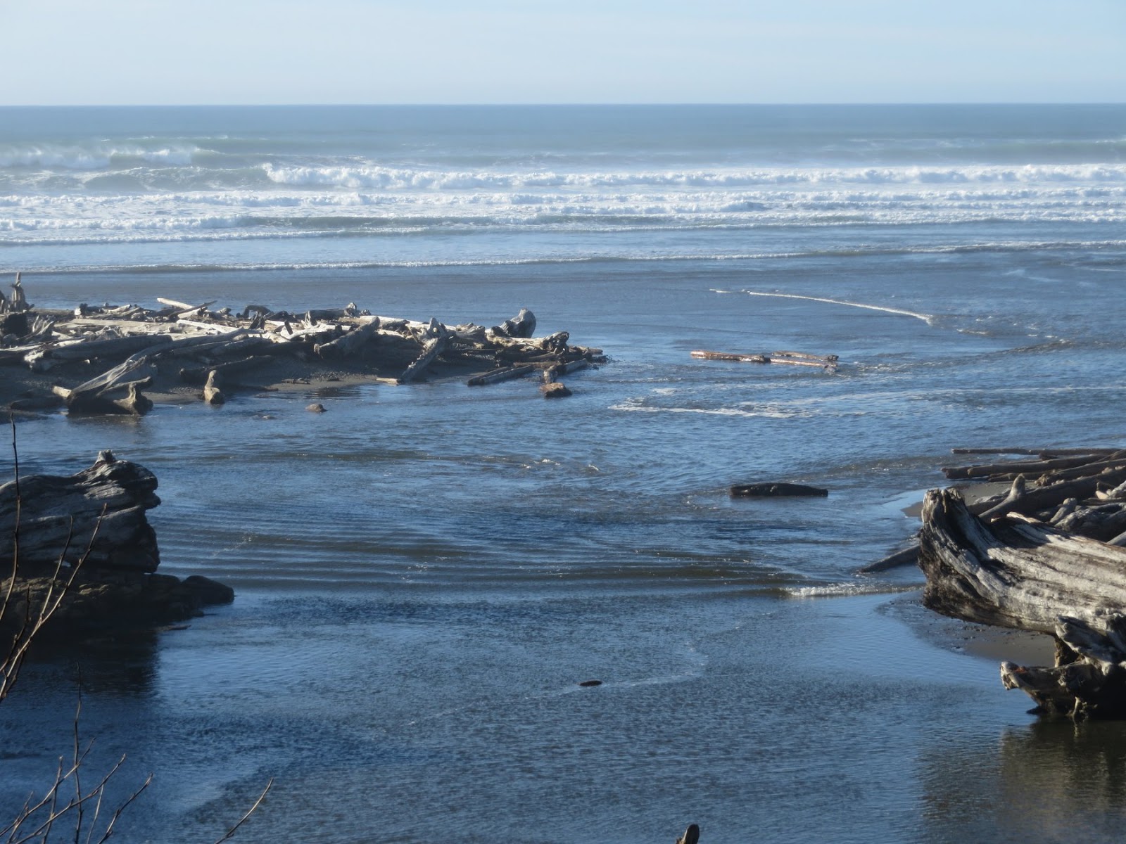
The tide was pretty high and every few minutes a larger wave set would spill across the beach and into the stream mouth, generating a small bore that slowly worked its way upstream.  It's easy to see how large wood from the beach gets rafted into the little estuary and pushed up against the bank below the lodge.

Remarkably, this is the first trip to this section of Washington's coast since I began the blog and the only post between Washaway Beach and Tsoo-Yess Beach. Some of these areas I know fairly well and some I don't, but regardless, it's been too long.

AERIAL VIEW


Lake Quinault


One of the themes I've come back to in talks the last few years is the that beaches are pretty easy to create. It doesn't take unusual circumstances and it doesn't require much time. It just takes some loose sand or gravel-size sediment and enough wave action to keep it moving around. They show up in a lot of places. But they don't all look like the ones in the Corona ads, which is what makes them so interesting.

Beaches are relatively common on larger lakes where there is sufficient fetch to generate reasonable waves, at least if there is the right size of sediment to build from. But lakes don't make beaches easy. Freshwater doesn't pose the same impediments to shoreline vegetation as does saltwater, so plants thrive at the water's edge, sheltering and stabilizing sediment. And in the Northwest, I suspect most lakes, at least prior to significant development, were fringed with fallen trees and big wood, which would discourage beaches.

AERIAL VIEW

This beach is at the bottom of the slope below the Lake Quinault Lodge on the south shore of the lake. A small point creates a favorable orientation for a small swash-aligned beach. Of course, on lakes like this, the beach may well have been created intentionally with the clearing of vegetation and maybe even the addition of some gravel, but I'm not sure.

As far as I know, the level of Lake Quinault is not managed and simply reflects the natural ability of the outlet (the Quinault River) to pass the water that flows in from the upper watershed.  The lake can fluctuate significantly -- you can see a wrack line behind the beach where the water reached about a week earlier.  I walked a section of the lakeside trail and was impressed by the amount of big drift wood rafted into the low areas surrounding the lake.


Tuesday, January 14, 2014

Seahurst Park


After many years of planning, the big beach project at the north end of Seahurst Park is finally underway.  The old seawall is coming out and a new beach is going in.  Right now the beach is off limits - and pretty much obscured by big piles of gravel and rock and lots of bright orange and yellow machinery.

Here's a post from this fall, before construction started:
Seahurst, October 2013
(and from there you can link back to earlier posts)

The south end (where the beach was restored in 2005) was looking great, but was awfully empty with access to the park closed off. I actually walked in from Eagle Landing to the south. Which qualified as my exercise for the day (hshipman:  Eagle Landing).

Sunday, January 12, 2014

Maury Schwartz


Several times during the spring of 1992, I drove north to link up with Maury Schwartz's coastal class on their field trips.  It was a great introduction to Puget Sound beaches, to Maury's infectious enthusiasm, and to his favorite local bakeries.  I took this photo at Sandy Point on one of those trips.

The more I read of the literature about beaches in those years, the more I became aware of Maury's contributions to the field. It was amazing to have someone of his stature so close by.

What I recall most about my early meetings with Maury up at WWU was his good humor and has commitment to his students.  Maury was first and foremost a teacher.   I may not have been one of his students, but he was one of my best teachers.

At a practical level, Maury was instrumental in educating us all about coastal processes and drift patterns on Puget Sound.  He and his students created a foundation on which we all now stand.


Notes about Maury from:
Ian at the Coastnerd Gazette
Dan at Reading the Washington Landscape

Friday, January 10, 2014

West Seattle


This winter's highest tide was supposed to arrive at dawn last Sunday morning, but the clear cold weather came with high pressure and that meant that a tide destined for 13.2' in Seattle barely made it to 12', a modest high tide at best.

Our best high tides seem to come when weather and pressure combine to lift a less than awesome tide into the truly unexpected range.  Like December 17th, 2012, when the 12' tide reached 14.5' (Whidbey Island).  Or when an El Niño elevates west coast water levels for weeks, like in January 2010 (Alki).

It seems like every winter for 20 years I've headed out at daybreak in late December or early January, hoping to see the Sound overflow. It's rarely spectacular, but getting out on the beach - or maybe getting outside at all - at dawn is still pretty special.  These shots are from Sunday morning, from Harbor Ave and from Alki Beach.

This post is a bit of an experiment and one that may get revised. I'm trying to post from a new app on an iPad, rather than my conventional use of blogger on the laptop. I'll let you know!