skip to main |
skip to sidebar

The new park officially opened in January. The toxic residues are cleaned up, much (but not all) of the historic structure is gone, and the beach has been given a fresh start.
Irondale: November 2011
AERIAL VIEW
The foundation walls of the old beehive charcoal kilns were left in place. They will gradually dismantle themselves, contributing to the lag of bricks and rubble on the low tide beach. The rapid initial erosion of this beach will settle down as the grade eases and a berm re-establishes itself, within and between the semicircular kilns.
 An originally unanticipated aspect of this project was the removal of a large volume of the fill on the site and the WDFW site immediately north (Chimacum Beach). Now, instead of a 6' scarp of eroding fill, there is a smooth transition from the berm to the backshore. This will give the beach more freedom to pick it's favorite line - there's already evidence that in some places it will end up waterward of the current line, in other places it will end up eroding the backshore a little. But the nice thing is that it has been given room to make this choice.

As readers may have noted from posts over the past year or two, we're seeing more and more examples of beaches being restored - often these are relatively small projects where an old structure or a bulkhead has been removed or where historic fill has been pulled back.
AERIAL VIEW
This was an old log dump used, as I understand it, for getting logs from trucks into the water. At least as of now, the Google Maps image still shows the old looped dock. But that's all gone now, replaced by a curving beach, a revegetated backshore, and an awful lot of large wood.
 I'm sure wood has always been a common component of Salish Sea beaches and there's plenty of evidence that suggests it can influence patterns of erosion and accretion - to a point. But from looking at many of the projects going in these days, you'd think beaches were all about wood, not about sediment! I'm excited about all these neat projects. I just hope the wood doesn't get in the way of the beach doing it's thing. Fortunately, in most cases, the wood doesn't seem to be having too much effect on the beach doing it's thing.
Dry Creek emerges from a small canyon midway along the otherwise unbroken line of bluffs between the Elwha Delta and Ediz Hook in Port Angeles. I've posted from here before (Dry Creek March 2008; October 2009) and this entry is sort of an update, along with a way of capturing photos from last week's visit.
 To the west of Dry Creek lies more than a mile of beautiful cliffs - no stairways, no seawalls. During the last few years, a broad foreland has developed along this stretch (see Elwha: August 2009). There's a good view of this feature from the top of the landfill. In the 1970s, a broad beach protected the bluffs along the same shoreline but in the 1990s, it was gone. Now it's back again. This is a huge amount of sand and gravel and suggests a far more complicated picture of sediment transport between the river and the spit than is typically told. Fortunately, thanks to the Elwha Restoration, there are plenty of folks watching these beaches and maybe in another decade we'll understand more than we do now. I suppose this feature may be gone by then - I wonder to where?
AERIAL VIEW

 To the east of Dry Creek is the Port Angeles landfill. A large seawall was built several years ago to protect the western portion of the landfill, where trash had historically been dumped over the edge. But the cliff to the east continues to erode, threatening a more recent part of the landfill that was constructed immediately landward of the retreating bluff (nope - doesn't make sense to me either). There's no easy or cheap fix, but moving the garbage out of the way is probably the more practical and forward thinking option - it was nice to see it getting serious consideration.

Another State Park -- another deep-seated landslide. I used Camano Island State Park to illustrate this symbiotic relationship in November (Gravel Beach: Camano Island SP), but much the same applies to this park on the west side of Whidbey Island.
The trail down to the beach at South Whidbey SP traverses the headscarp of the main slide, then winds through hummocks and around sag ponds, before arriving at the lower bluff, which is where the recent movement has been and which has taken some of the trail along with it.
AERIAL VIEW


This is a wonderful stretch of beach. Bush Point lies to the south, Lagoon Point to the north (Gravel Beach: last year, same afternoon). Other than the stairs at the park and a few drain pipes coming down the high bluff south of the park boundary, it's a pretty wild beach.
There are a couple of waterfalls that plunge directly to the beach and both were running full, their streams cutting through the thin sand layer deposited by the previous high tide. And there is a large glacial erratic. My petrology is rusty, but I was told once that this was a block of dunite, most likely from Twin Sisters near Mount Baker (anyone want to confirm or refute?)
 There are some spectacular landslides - historic ones and new ones - on the bluffs between here and Bush Point. The sun was going down or I would have checked them out on this hike. Maybe later this spring.
Side note: This is my 60th post from Whidbey Island since this little adventure began back at the end of 2005. 'Whidbey' is the most common label on the blog after 'Washington' and 'Puget Sound.'
Sound Waters is held every year on the first Saturday of February and whether I stay for the afternoon classes or skip out after lunch to go to the beach, it's always a good day. This year they moved the venue from Langley to Oak Harbor High School, so I started near the north end of the island and worked my way south.
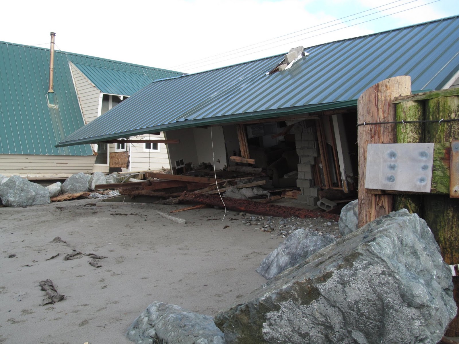
 West Beach was calmer than on my last visit - back on December 17th when a storm coincided with a record high tide and caused a lot of damage to both homes and bulkheads.
Gravel Beach: 17 December 2012
This community is a poster child for imprudent development. It certainly isn't sustainable in the long run, particularly with rising sea levels. At least not without a great deal of expense and heavy duty fortification.
AERIAL VIEW
It's a wonderful place at low tide on a sunny July afternoon, but events like December's storm are exactly what built this ephemeral spit of land and what will wallop it again and again. Peat ledges on the foreshore are evidence of the beach's landward retreat. Tsunami warnings are reminders of the beach's lack of elevation and proximity to shifting plate boundaries. The old failed seawalls at the south end are a fitting monument.


Cama Beach appeared on these pages frequently last year and probably will again this year. These are from a brief foray in mid-January following some more landsliding. Not only has the big gully been active, but a couple of new slides have occurred as well.
The big slide we posted about last year (search on the label 'camano') was quiet all summer and early fall, but has gotten more active this winter. Water was flowing over the top during this visit and was eroding the sandy unit below the till. This appears to undercut the till which then fails in larger blocks, although nothing too dramatic has happened yet this year. Most of the colluvium in the gully still looked like the trodden and rained-on remains of last year's debris. I would expect more failures as long as the water is flowing, but I wouldn't pretend to guess how large.

 One reason for my visit was reports of a new slide south of the one I just described. Sure enough, there had been a fairly large debris avalanche on the lower half of the slope, in line with a substantial gully that probably corresponds to an earlier slide. Water was flowing from somewhere mid-slope. This new slide is immediately north of one that occurred in the late 1990s. There is plenty of tree debris on the beach, and a fair amount of dirt, but nothing like the other slide. There's a steep bare headwall at the very top of the slope, but the upper slope doesn't appear to have failed in this event. I suppose the recent slide could make that more likely, at least if conditions stay wet.

 There was also a small slide - a small earthflow more precisely - on the slope nearer the resort, above where the old bungalows were. When the park was redeveloped, a decision was made to remove several of the old bungalows at the north end, at least in part due to their vulnerability to slides. Probably a very good idea.
AERIAL VIEW
San Francisco's Ocean Beach transitions southward into progressively higher bluffs in the vicinity of Fort Funston, which then continue to rise on into Daly City towards Mussel Rock. About a mile of the bluffs between Fort Funston and the northern portion of Daly City are marked by a spectacular deep-seated landslide complex - characterized by rolling topography and shore-parallel ridges and swales.

AERIAL VIEW
 My brief research suggests a range of ages for this slide - which is often the case with these features - since some people are referring to the age of the overall feature, whereas others refer to specific events or even to more recent reactivation. From what I can tell, the landslide dates back hundreds of years, but experienced significant movement in the 1906 earthquake and continued to experience some additional sliding during the past century. Regardless, the railroad, and later the highway, that was built on the face of the bluffs from San Francisco to Pacifica (and beyond), in the early 1900s, has not survived - except in small pieces and on interpretive signs.
 This part of Pacifica is built at beach level -- perhaps on old backshore dunes. But just as with the bluffs shown in the previous post, this beach has been subject to significant erosion. For this and many parts of the California coast - the El Nino of the 1982-83 winter was a tough one. The community has gone through a few iterations of fortifications and is now perched behind a high seawall with a big rock apron.
AERIAL VIEW
It was a blustery day (the photos were taken on December 21st), waves were building, but the tide was not particularly high. I suspect these were pretty tame conditions and certainly not enough to discourage the fishermen.

 The northern portion of Pacifica is built on the 80' vertical edge of a rapidly eroding marine terrace. Apartment buildings - some older; some recently remodeled - are lined up along the edge, protected by a discontinuous line of riprap.
AERIAL VIEW
I assume there is some controversy about the riprap. But I suppose that riprap is all there will be in another decade or two. There certainly won't be any more beach at high tide by then. Temporary protection of private structures or long-term protection of public resources? It looks like the trade off for more riprap is better access to the little bit that's left?
 Daly City is where the San Andreas fault heads out to sea. It arrives from the south by way of a series of fault valleys and elongated lakes and reaches the coast just north of Mussel Rock. It continues northward offshore past the entrance of the Golden Gate before reconnecting briefly with California at Point Reyes.
There's a large divot where the fault intersects the high bluffs, at least in part due to past landslides. In the 1960's tidy rows of homes were built along the top edge of the bluffs. Remarkably, most of them are still there.
AERIAL VIEW
Mussel Rock Park is the site of a historic landfill, now closed, but heavily fortified with riprap. Mussel Rock itself is a large block of Franciscan rocks squeezed out along the fault, and described in the opening passage of McPhee's Assembling California. As McPhee notes, this is a good (but often foggy) spot to "sit and watch the plates move." Which I suppose is the attraction of those homes perched at the edge of the precipice, witness to storm waves, landslides, and plate tectonics.


 An originally unanticipated aspect of this project was the removal of a large volume of the fill on the site and the WDFW site immediately north (Chimacum Beach). Now, instead of a 6' scarp of eroding fill, there is a smooth transition from the berm to the backshore. This will give the beach more freedom to pick it's favorite line - there's already evidence that in some places it will end up waterward of the current line, in other places it will end up eroding the backshore a little. But the nice thing is that it has been given room to make this choice.