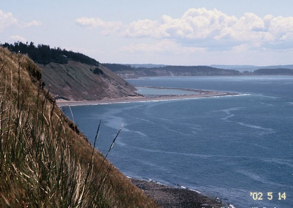
A series of photos illustrating the role of overwash in shaping barrier beaches is a standard element in many of my beach talks and one of my favorite examples is Perego's Lagoon on the west side of Whidbey Island. This Saturday I was up on Whidbey (at Sound Waters) and just before my presentation, someone mentioned that waves had recently breached that spit.
So I skipped out on the third session of the day and drove up to Ebey's Landing to check it out. Sure enough, there was a small breach in the berm crest near the south end and a fresh deposit of sand, gravel, and logs in the lagoon. This looks pretty small compared to some of the older, preserved ones nearby, but still very neat to visit before it patches itself back together (which it will probably do pretty quickly).
Although I don't know for sure, this likely occurred on December 20th, when a strong wind storm coincided with a high tide and a strong surge. There have been reports, and numerous videos, showing the fierceness of that storm, particularly in northern Puget Sound (Birch Bay got hit really bad). Here are some previous posts from Perego's, some of which show the earlier overwash fans quite a bit better: Gravel Beach: Perego's Lagoon
The Miller Peninsula, on the north side of the Olympic Peninsula, lies between Discovery Bay on the east and Sequim Bay on the west. Diamond Point is the cuspate foreland that marks the northeast corner and the entrance to Discovery Bay. Travis Spit extends from the northwest corner across the mouth of Sequim Bay. In between is about 5 miles of gravel and cobble beach, backed by steep bluffs. AERIAL VIEW
The one exception to this long stretch of bluffs is Thompson Spit, located near the eastern end. The spit is a looped barrier - basically a spit that extends out from the coast and then reconnects farther down the shore (in this case, west to east, which is consistent with what we expect of longshore transport here). They're rarely symmetric and this one is no exception. Their updrift ends are often tangent to the adjacent bluff - as if the beach reached a sharp bend in the coastline but couldn't turn fast enough. The downdrift ends tend to merge back to the coastline asymptotically. If there is a tidal inlet, it's usually near this downdrift end (that's not the case at here, which just suggests a more complex geologic or historic story that I don't know).
The berm on the western end is low and narrow and there was evidence of overwash. The lagoon was draining through a shallow inlet and the beach in front of the inlet was marked by several organic ledges (the upper looked more like sawdust - perhaps evidence of some human history?) - which is typical where a barrier beach has migrated landward, exposing old marsh and lagoon sediments. The central point of the spit is marked by a large mound that appears to be fill - was there an old cabin or small mill here once? This may have been referred to as Deadman's Spit at one point - the dead man being a guy named Thompson in the 1860s. But that may be reading too much into a local history I found online (Diamond Point history).
I'd like to come back and explore more sometime - lots of unanswered questions. But only the western portion of the spit is in the State Park and I'm not sure how welcoming the owners of the eastern half are likely to be. Looped barriers are common on Puget Sound - here are a few we've visited before: Perego's Lagoon: December 2015 Cama Beach: April 2017 (and many previous) Kayak Point: January 2009
Here's the third of my Ebey's Landing posts from Black Friday, a week and a half ago. The 3 1/2 mile loop from Ebey's around Perego's Lagoon is the best coastal hike on Puget Sound. Yes, there are other nice ones, but this is more special than the rest. Especially on a day like this one! Most people hike the loop counterclockwise, hiking up along the edge of the bluff and then returning along the beach. The last time I hiked the whole loop was also right after Thanksgiving, but on a very foggy day! Perego's Lagoon: 2008 (or for a different perspective on the same trip, see hshipman)
Perego's Lagoon is formed behind a narrow barrier beach - a looped barrier is one term I've heard to describe this kind of feature, a closed spit might be another. The general pattern of longshore transport is from north to south, although it's probably not quite that simple along here.
AERIAL VIEW In the previous post I mentioned the perched dunes on the top of the bluff, which you traverse as you walk the crest of the slope to the north, with the grassy angle-of-repose bluff falling off to your left and the forest to your right. The bluff trail provides great views down at the lagoon and the spit, including some very nice overwash fans (I believe washover fans also works). The backside of the barrier is marked by several of these features, which mark occasions when waves overtopped the berm during a high tide storm and spread sand and gravel into the lagoon.
The northernmost is interesting for several reasons. First, it is fairly recent. It appeared sometime between the 1970s and the early 1990s. I'd put my money on the 1979 storm, which walloped this part of the Sound, but am in the process of seeing if I can find out more. Second, it completely crosses the lagoon, isolating a small portion to the north. I don't know whether these fans represent an event contained within a single storm and tide cycle, or whether they may have remained open for longer. I've also wondered how this feature would record a tsunami coming down the Strait!
Ebey's Landing lies below a low spot on the bluff on the west edge of Ebey's Prairie, a little west of Coupeville. The road drops down to a stretch of broad backshore terrace where the original pier had been built (it's a pretty exposed location for a pier). It's now a popular taking off spot for beach hikes, including the classic loop to the north. I've posted about Ebey's Landing before on Gravel Beach, but here's one from my other blog (hshipman). AERIAL VIEW
I mentioned in the previous post that the beach along this reach often diverges from the bluff. Here, the beach has filled in a curve in the coastline, creating a fairly wide low area. A little farther north of here, the beach takes an even wider excursion seaward of the original bluff line, creating mile-long Perego's Lagoon (next post).
Ebey's Prairie is a good place to think about the last stages of the Vashon glacier. Glacial marine drift, exposed in the upper portions of bluffs near here, records sediment deposited immediately after the ice left and marine water reoccupied the area. What you don't see without LIDAR or perhaps, really good low-light conditions, is the old strandlines that follow contours around Ebey's Prairie, marking the rapid retreat of the sea as glacial rebound returned Whidbey to its preglacial elevations. Imagery shows dozens of faint shoreline traces on the gradual slopes of the prairie.
Something you can definitely see, looking north along the top of the bluffs, is the dunes perched above the bluff itself. They are stable and largely forested now, but indicate conditions when wind blowing over the Strait carried fine sand up the bluffs and deposited it above the crest. Not surprisingly, these bluff-top dunes are called perched dunes and can be found elsewhere on the northwest side of Whidbey (West Beach 2012), on Protection Island farther west along the Strait, and on Lake Superior (Grand Sable Dunes 2010), among other places.
It was a foggy Sunday afternoon and we could barely see the beach from the trail along the top of the bluff. On a nice day, the views from this spot on the west side of Whidbey Island are spectacular. It was nicer weather last February (Perego's Lagoon), although I didn't get to the north end on that trip. This trip left me wanting to come back and spend more time checking out the lagoon itelf, particularly the washover fans and what appear to be small marshy barriers inside the lagoon.
The ridge that separates the northern portion of the lagoon formed sometime between the late 1970s and the early 1990s (the 1979 storm that took out the Hood Canal Bridge may be the best candidiate), but as recently as last winter was the site of additional washovers. There are several more fans on the back side of the barrier along its central section, though none extend as far across the lagoon as this one. The beach - typical of the western shore of Whidbey - is a wonderful mix of gravel and sand in patterns that are sometimes rhythmic and sometimes not.
The bluffs between Point Partridge (OCT2006,FEB2006) and Ebey's Landing consist of a thick pile of gravel left by the retreating glaciers. The lack of cohesive sediments, complex stratigraphy, or forest cover result in uniform angle-of-repose slopes that are distinctly different than others on Puget Sound. Net drift is to the southeast - where the gravel eventually winds up in Keystone Harbor, where it must be periodically dredged to allow the ferry to get in. A couple of miles north of Ebey's Landing, the beach splits from the coastline, forming this large lagoon before reconnecting with the bluffs farther south. The result, with help from the National Park Service and the Nature Conservancy, is a 3+ mile loop that is the best shoreline hike on Puget Sound.
The gentle waves breaking on the beach today were about 10 seconds apart, suggesting they began as much bigger waves out on the Pacific. Occasionally a big storm comes over spit, recharging the lagoon and creating gravel washover fans on the backside of the barrier.