Showing posts sorted by date for query lily point. Sort by relevance Show all posts
Monday, July 06, 2015
Barnum Point
Thousands of years of wave action has carved off the southeasterly face of this glacial ridge, creating a beautiful high bluff. A thick till drapes the ridge, with outwash sand and gravel below. The relatively straight line of the bluff faces directly down Port Susan, or pretty close to it, making this a nice example of a swash-aligned bluff (something we also see in other places around the Sound).
AERIAL VIEW
Eroding till inevitably leaves behind cobble and boulders. Some is on the beach, but there were also clearly some very large rocks far offshore (some just barely breaking the surface during the paddle and creating some wonderful little rips where the current was fast).
The eagles were out in force - although they seemed to be too intent on watching me than to actually be catching any fish. There were at least four - and there may have been more but they all looked the same to me and I wasn't sure I was double counting.
Increasing recognition of the importance of eroding bluffs in the overall formation of beaches and spits on Puget Sound has resulted in some significant conservation purchases in the last few years. In the past, coastal conservation acquisitions were mainly focused on salt marsh and estuarine habitat, so it's neat to see beaches and even bluffs getting attention. Not only are these bluffs geologically and ecologically significant, they are iconic Puget Sound landscapes.
Barnum Point is one of the more recent examples of this:
Barnum Point (Nature Conservancy)
For another example, check out Lily Point on Point Roberts.
Labels:
camano,
puget sound,
salish sea,
washington
Location:
Camano Island, WA, USA
Saturday, August 23, 2014
Beach Grove
Every year, I end up in Richmond or Tsawwassen early on a Saturday morning in August, prior to catching the ferry over to Salt Spring Island. And every year, I have a choice of beaches to visit. This year, I went back to Beach Grove (2009) and Centennial Beach (2009).
AERIAL VIEW
Beaches can be narrow for a lot of reasons. In this case, I suppose they include 1) a dearth of coarse sediment from the south, 2) the fact that the community was pretty much built on top of the berm and backshore, and 3) the broad fine-grained flats essentially bury the intertidal beach (the flats intersect the beach face at a very high tidal elevation).
Labels:
british columbia,
canada,
point roberts,
salish sea
Location:
Beach Grove Road, Delta, BC V4L, Canada
Saturday, February 25, 2012
Wolf Bauer
| West Point 2004 |
| Golden Gardens 2011 |
| Seacrest 2011 |
| Brackett's Landing 2009 |
| Ambleside 2011 |
| Tolmie 2009 |
| West Point 2010 |
| Birch Bay 2010 |
24 February 2012
Wolf,
As you begin your second century, I wanted to remind you of what an amazing difference you have made for Puget Sound shorelines and
for the people who visit them.
You were instrumental in raising awareness of shorelines and in creating a demand for shoreline protection. Today, it’s easy to take our beautiful beaches for granted, but without the amazing efforts of you and others in the early 1970s, this place would be a very unattractive place. Your language and your ideas have remained lasting elements of Shoreline Master Programs across the state.
You described accretion beaches as an endangered species. At the time, you may have doubted our progress, and it’s true that we have lost some special places. But thanks to your work, many remain intact and more are becoming public. Lily Point on Point Roberts is now a county park.
In the 1980s you spoke adamantly of the need to restore our urban beaches and to enhance the public’s shoreline experience. But you did not just talk about it, you gave us examples. Today, we have examples everywhere: in Seattle, Tacoma, Bremerton, and elsewhere. And there are a new generation of projects such as the Sculpture Park Beach in Seattle and Marine Park in Fairhaven that were inspired by your example and carried out by impassioned individuals who had learned from you.
People enjoy our most spectacular urban beaches, yet many do not realize that these places were once buried in riprap and would be still were it not for your efforts. People love the beaches at Discovery Park, Golden Gardens, Birch Bay, West Vancouver, and Tolmie State Park. They think these places have always been this nice!
This year, we are mapping feeder bluffs throughout the Sound – the feeder bluffs that you taught us were such a critical element of the shore-process corridor. Also this year, I was approached about what to do about salt marshes choked with cut logs from decades of sloppy log-rafting practices. I jumped at the chance to share your presentation on this subject from almost two decades ago.
Increasingly, parks managers and and government regulators and fish biologists are looking for opportunities to restore beaches and to put sediment back into the system, not lock it away behind walls of rock. People still build bulkheads, but doing so is widely discouraged and is increasingly difficult. In some places we are actually pulling seawalls off the beach and removing riprap from our spits.
Your legacy runs deep on Puget Sound and our shorelines are far, far better places today than they ever would have been without your incredible passion and your tireless commitment.
Thank you,
You were instrumental in raising awareness of shorelines and in creating a demand for shoreline protection. Today, it’s easy to take our beautiful beaches for granted, but without the amazing efforts of you and others in the early 1970s, this place would be a very unattractive place. Your language and your ideas have remained lasting elements of Shoreline Master Programs across the state.
You described accretion beaches as an endangered species. At the time, you may have doubted our progress, and it’s true that we have lost some special places. But thanks to your work, many remain intact and more are becoming public. Lily Point on Point Roberts is now a county park.
In the 1980s you spoke adamantly of the need to restore our urban beaches and to enhance the public’s shoreline experience. But you did not just talk about it, you gave us examples. Today, we have examples everywhere: in Seattle, Tacoma, Bremerton, and elsewhere. And there are a new generation of projects such as the Sculpture Park Beach in Seattle and Marine Park in Fairhaven that were inspired by your example and carried out by impassioned individuals who had learned from you.
People enjoy our most spectacular urban beaches, yet many do not realize that these places were once buried in riprap and would be still were it not for your efforts. People love the beaches at Discovery Park, Golden Gardens, Birch Bay, West Vancouver, and Tolmie State Park. They think these places have always been this nice!
This year, we are mapping feeder bluffs throughout the Sound – the feeder bluffs that you taught us were such a critical element of the shore-process corridor. Also this year, I was approached about what to do about salt marshes choked with cut logs from decades of sloppy log-rafting practices. I jumped at the chance to share your presentation on this subject from almost two decades ago.
Increasingly, parks managers and and government regulators and fish biologists are looking for opportunities to restore beaches and to put sediment back into the system, not lock it away behind walls of rock. People still build bulkheads, but doing so is widely discouraged and is increasingly difficult. In some places we are actually pulling seawalls off the beach and removing riprap from our spits.
Your legacy runs deep on Puget Sound and our shorelines are far, far better places today than they ever would have been without your incredible passion and your tireless commitment.
Thank you,
Hugh
NOTE: Wolf turned 100 on February 24th. These photos, most taken recently, are all nourished beaches designed by Wolf in the 1970s and 1980s. Their captions link (in most cases) to previous posts on those places. Previous Gravel Beach posts mentioning Wolf can be found at: Bauer Posts.
Labels:
british columbia,
puget sound,
restoration,
washington
Sunday, October 16, 2011
Lily Point
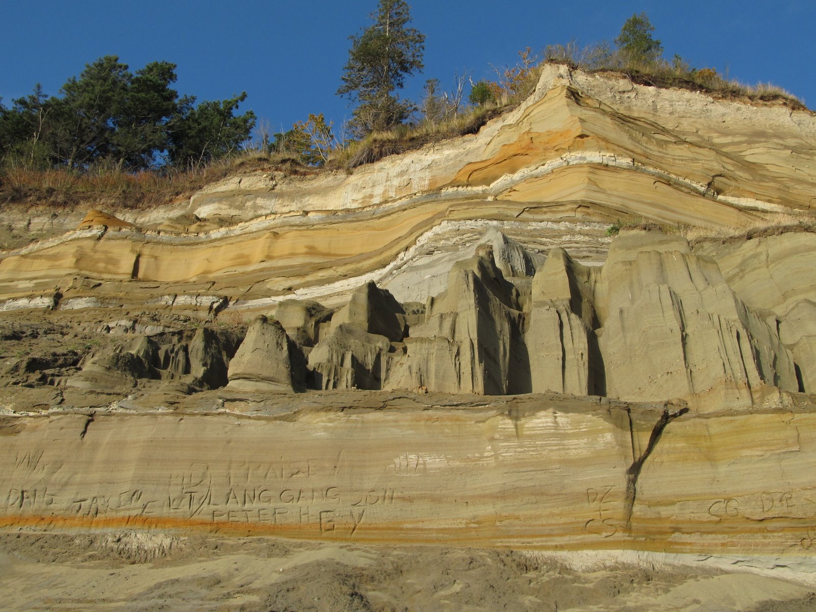
Lily Point itself is a low cuspate foreland (recurved spit?), but the bluffs that surround it are high and steep. The south bluff contains a large deep-seated landslide (Lily Point: August 2011), whereas the north bluff is a simpler, but even more spectacular cliff of either glacial outwash or older fluvial sediments (paleo-Fraser River??), although I suspect the story is more complicated than that.
This bluff dumps an awful lot of sand onto the beach - and the beach to the north widens quickly to form a small barrier. Two miles north, after another section of cliffs, this beach becomes the Maple Beach described in the previous post.
Labels:
point roberts,
puget sound,
salish sea,
washington,
whatcom
Location:
Lily Point, Point Roberts
Maple Beach
At low tide, one can practically walk across Boundary Bay on the sand flats, but at high tide the water comes right up to the seawall. The upper beach and the berm of this sand spit is long gone beneath the roadway, although in recent years, nourishment has been used to rebuild the beach and provide protection to the wall itself.
Maple Beach: August 2006
The beach derives much of its coarse sediment from the bluffs at Lily Point south of here. And this beach is just the base of a much larger system of historic and modern spits that extends north across the border to Centennial Beach and Beach Grove in Tsawwassen.
The "C" on the marker might stand for Canada, although I suspect it does not. The border is a bit of a groin and the seawalls are just as impressive north of the border as south.
Labels:
point roberts,
puget sound,
salish sea,
washington,
whatcom
Location:
Maple Beach, Point Roberts
Sunday, August 07, 2011
Lily Point
Lily Point would have made a spectacular resort or development, but it makes a better park. Lots of hard work over many years led to its acquisition and recent dedication as a park and a marine reserve. This is the forested southeast corner of Point Roberts, a few steps removed from the residential development of Maple Beach to the north and of South Beach and the Marina to the west. For most Americans, visiting it requires a passport, since you must cross the border (twice) to get here.
From the tip of the point, you can look south to Lummi Island and Mount Constitution, northeast to the high rises of New Westminster and Burnaby in the Fraser Valley, and southwest to the Gulf Islands. On a clear day, Mount Baker rises to the east.
Lily Point itself is a cuspate foreland, bracketed by high bluffs. The bluffs to the north are bare and steep. The bluffs to the west consist include a large, deep-seated landslide, and is well-forested except in its steepest sections. It has all the classic symptoms --soft clay exposed on the beach itself, a steep shore bluff and a steeper head scarp, separated by a forested bench. I don't know how often it moves, but in the late 1990s, local residents in the area reported noise and dust when a big section let go.
Waves from the south erode the southwest bluff, carrying sediment both west to South Beach (where the sediment is periodically bypassed around the marina entrance) and north around the point towards Maple Beach. Maple Beach in the U.S. and Centennial Beach and Beach Grove on the B.C. side are part of a large complex of spits formed over the millennia by the erosion of Lily Point and then incorporated into the fringe of the Fraser delta.
Lily Point is by no means pristine and over 100 years ago it was the site of a major salmon cannery - remnants of which mark the beach on the north side of the low point. Native Americans/First Nations peoples apparently fished the point historically, but neither they nor the salmon were much of a match for industrial fishing.
Labels:
point roberts,
puget sound,
salish sea,
washington,
whatcom
Sunday, August 16, 2009
Centennial Beach
Lily Point, at the southeast corner of Point Roberts, has been feeding sediment to the beach for millenia and waves have been sending it north to form the beaches that extend from Maple Beach on the American side into Beach Grove on the Canadian side. Yes, several thousand cubic yards of American dirt going to Canada every year -- no charge, no duty, no intention to return. The sediment has accumulated in a series of prograding spits in the northwest corner of Boundary Bay, where they created the large marsh behind and beneath Beach Grove - now diked and managed to accommodate the growth of suburban Vancouver (this is all part of Tssawwassen).
The long history of accretion means there's a broad sandy backshore, and even some semblance of low dunes. The upper foreshore is a narrow band of gravelly sand, running along the edge of the broad flats of Boundary Bay. The transition between the upper foreshore and the flats occurs at mid-tide or above. The lower beach appeared to be a lag surface of small gravel.
What I found intiriguing was the strong southeast-northwest fabric to the lower beach - a pattern seen both in gravel ridges (amplitude of ten cms or so and wavelength of several meters) and in the sand between them (amplitude of mms and wavelength of several cms). Strange. These did not look like ripples or cusps or any sort of depositional feature - they looked more like erosional features (I'm not sure why I felt that). And their orientation was parallel to the large fetch from the southeast - where I might have expected just the opposite. It looked like a surface that had been scoured by strong southeast winds and waves. As with every beach, there is a story here. I just don't have much clue as to what it is.
Labels:
british columbia,
canada,
point roberts,
salish sea
Subscribe to:
Posts (Atom)