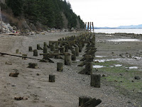


Clayton Beach is at the southern end of Larrabee State Park, a 10-minute walk down the old interurban line, which headed "out to sea" here, running on piles in the bay parallel to the shoreline all the way to the McElroy Mill (long gone) at the south end of Chuckanut (historic photo). The Great Northern had already used up what little space there was along the base of the cliffs in 1902, forcing the trolley to choose the marine route. The interurban stopped running at the beginning of the Great Depression (the First Great Depression?), but the piles are still sticking out of the beach and there is a strange rock and timber structure further offshore - maybe a breakwater?
I don't know the story behind the eroding sandy bluff behind the the beach. It's rich in clam shells, but I wasn't sure whether it was a natural deposit or some sort of fill associated with the construction of the railroad. Time to do some holework - or come back for longer. I liked the way the sand from the eroding bluff spread down across the upper beach to end in such a distinct line against the gravel.

No comments:
Post a Comment