skip to main |
skip to sidebar

 Seattle desperately needs to reconnect with its waterfront- we can do better than souvenir shops and uninteresting industrial buildings. But how to deal with railroads and highways? The new park offers one approach - a partial lid zigzagging from the top of the bluff down to the shore, but it won't work farther south - with or without a viaduct.
The railroad was originally built as a trestle over the lower beach and was later backfilled and expanded to provide room for Alaska Way. The topography still provides a pretty good sense of where the original bluff and beach were located - in some places a very long way back from the current shoreline. All the land in these pictures is fill.

 Does this beach have a name? Sculpture Park Beach? Artificial pocket beaches on industrial shorelines are an interesting notion, but require some careful planning. I've been hearing about this one for some time, but this is the first time I've seen it. It seems like a nice aesthetic and recreational element to an otherwise stark shoreline, though I wonder how much biological value it offers.
The fence and the high tide and my schedule prevented a careful review, but... The orientation strikes me as pretty reasonable for the location - pocket beaches orient to the local wave field. The groins guarding the entrance seem excessively long and there was too much undersized rock -- too bad we couldn't do this with big granite boulders the way Vancouver does, since it would be more attractive, safer for kids to scramble around on, and more durable. A distinct gravel berm had built up near the high tide line, maybe the result of the seasons's earlier wind storms. The most noticable aspect of the beach was the enormous amount of wood, and garbage, filling the cove. This isn't unusual along modified shorelines where riprap and seawalls prevent floating debris from accumulating - so it concentrates in beaches and small coves and the north corners of marinas. If a beach has a southerly orientation and is enclosed by big groins, like this one, the problem is probably exacerbated. I don't think wood accumulates as much in the little cove/beach at the CSO outfall in just north in Myrtle Edwards Park, which has a slightly different orientation.
I'll have to come back at a lower tide and with more time.
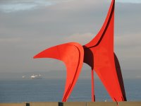
 Early this morning I walked through the new sculpture park and then down past the grain elevators - a pleasant, albeit roundabout route from my car to the meeting. They opened the park with great publicity this past weekend, though it isn't actually done yet. The lower portions, from the railroad overpass down, are still under construction.
It's a great setting, a great redevelopment of an industrial mess, and a great way to walk down to the beach. Not that there is very much beach once you get there! The park juxtaposes wonderful art, bright colors, and lots of sharp edges and acute angles with native landscaping and spectacular views. I'm a big fan of different ways to connect urban folks to the Sound - and this makes a nice alternative to watching the sun set over the Olympics on a summer evening while driving north on the upper deck of the viaduct (may it be forever preserved in photos and memories, but please, oh please, not in concete).
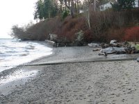
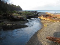 Still back in December. A small stream mouth on a beach within view of downtown Seattle. In view, that is, if you have an office in the northwest corner on the 50th floor and you have a good telescope - I guess the rest of us have to go to the Space Needle and imagine the details. The topography suggests what may have once been a small estuary, although much of it is now occupied by a parking lot and the road.
The beach here is partly a small delta and partly just a slow spot in the beach. There is a little bit of a bay in the shoreline here, so the flux of northbound sediment may decrease, causing the beach to build up...sort of like traffic approaching the ship canal bridge on southbound I-5.
Much of the sand on this beach can probably be traced to some very large landslides a couple miles south of here that were active in the late 1990s.

 Shine Road follows the top of the bluff for a mile or so. Not much room left and in a hundred years the beach plans to be where eastbound lane is now. Someday the road will get relocated, but not before the county spends many years and an awful lot of money trying to save it.
This winter, we've seen good wind storms practically every week. The bridge was closed for 60-70 mph gusts shortly after this picture was taken (enough time for me to get across). Glad it didn't sink like it did in 1979. Usually when this bridge keeps me from getting home for dinner, it's because I have to wait for it to open so a Trident sub can go through (you might ask why the submarines can't go under a floating bridge, but I doubt it's really that simple).

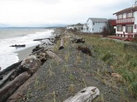 Over the past several thousand years, the Dungeness River has emptied into the sea in different places across the broad Grays Marsh and Jamestown landscape. Today's river mouth is deflected eastward in the lee of Dungeness Spit (remember, click on the title of the post for an aerial view). The beaches to the east of the modern river mouth, along the old delta front, comprise one of the longer stretches of low bank shoreline in the region. Far too many homes built along a shoreline that doesn't want to stay put. Last year's big storm borrowed some of these folks' beach. But instead of responding with 1000' of riprap, they constructed an artificial gravel dune, which alleviates some of the erosional pressure and should reduce flooding. In a couple years it should look pretty natural, although it's basically just a naturalized dike.
 We've caught up to December. This stretch of bluffs supplies sediment both south to Gibson Spit at the mouth of Sequim Bay and north toward Jamestown and the mouth of the Dungeness.
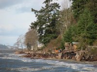
 The week of Thanksgiving. A miserable wet and windy day in Seattle, but a wonderfully blustery day on Port Susan. Seems like everyone wants their own private tram to cart them up and down their 150' bluffs, which is why we were out today. This is wonderful stretch of beach, particularly at low tide (which it wasn't this trip) when you look out across the front of the Stilliguamish Delta. The sand on the upper beach is moving north with longshore drift (waves from the south) but the low-tide terrace is really just part of the delta and is probably expanding to the south.
There is lots of big wood in Port Susan since it's north and downwind of Everett and the mouth of the Snohomish River. This was one of the largest log jams I've seen on a beach - it starts to act like a groin, impounding sediment and affecting local wave action.
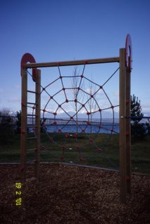
It's time to catch up a bit -- beginning with a blogger's retrospective. The picture was my best effort at something related to the web that was still taken near a beach. Salsbury Point. A great example of small-scale beach nourishment carried out in October 1995, though it could use a little refreshing. Deserves a future post.
I began this blog a little over a year ago - 60 posts and I suppose a couple hundred pictures. I don't even know if Google/Blogger limits my storage, or do they just keep adding servers on my behalf in big warehouses in places like eastern Washington with cheap land and cheaper electricity? Or maybe tomorrow they'll tell me I've exceeded my allotted space!
I have no idea how many people visit the site, though I don't expect many do unless I specifically point them to it. I know no one links to the blog, since it still fails to come up in any search engines (maybe a good thing). I think there is some way to subscribe to it, in case you want to get updated some evening when I start posting stuff after a two month hiatus. I think the site has actually served my needs very well -- I just enjoy pushing my pictures and my musings out there. Hopefully, some folks enjoy it or learn something about their favorite beach or come away with an idea for a thesis, but if someone doesn't like it, they can just click on the "Next Blog" in the top right and go visit someone else.


