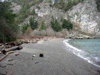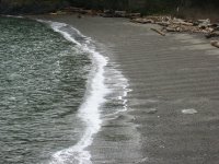
This is a wonderful little pocket beach near the southeast end of Lopez. High basaltic cliffs on the north side and an extensive marsh behind the barrier. Nice beach cusps/ripples last Thursday. The high points, a little over 2 meters apart, are gravel, while the low points are sandier. Most extend uniformly up and down the beach face, indicating that their formation was sustained, and consistent, throughout an entire tide. I would speculate on the nonlinear dynamics behind this, but would trip all over myself doing so. These features seem more common on swash-aligned pocket beaches like this one, but are by no means limited
 to them.
As with virtually every other beach I've seen since last month's storm, there was fresh gravel deposited on the backside of the barrier. The gravel had washed over the grass and logs and into the dense thickets (nootka rose?) behind the beach. I am guessing that the barrier moved a foot or so landward during this last event. But I don't know if that event was a 20-year storm or a 100-year storm, so I can't estimate a long-term migration rate.

No comments:
Post a Comment