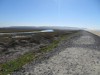
It would have been fun to spend a little more time exploring the lower reaches of the river and the estuary, but I had to settle for my excursion on the south side and some views from the Imperial Beach side on the north. It would have been nice to walk to the river mouth, which emerges through the sandy barrier without the help of jetties or dredging or a riprapped channel.

 The Tijuana River probably has the largest relatively intact estuary left in this part of California and it's the site of the Tijuana National Estuarine Research Reserve. It's not without stressors - the inevitable changes to hydrology and sediment loading, a heavily developed upper watershed (much of it in Mexico), encroaching subdivisions and an naval airfield in Imperial Beach, and an assortment of agricultural (horse farms) and related activities in the valley just upstream of the estuary.
AERIAL VIEW
 Apparently, heavy rains flush enormous volumes of sediment out of the valleys in Tijuana, along with an awful lot of garbage. Some large sediment basins have been constructed, but the sediment and related flooding has seriously impacted the lower river. At the same time, my understanding was that these rivers flushed out enormous amounts of sediment even prior to development and one report I saw suggested the river is actually delivering less sediment to the coast than historically.


No comments:
Post a Comment