Monday, October 02, 2017

Promontory Point


In three weeks spent driving 6200 miles around the western United States, this was the only noteworthy beach I could come up with. If it's a beach at all. We saw some other lakes (Flathead Lake Lake Monona, Lake Powell), but none generated any relevant beach pictures (Flathead and Monona have appeared in the blog previously). I guess we also drove through a lot of Paleozoic and Mesozoic sand dunes and possibly some beach deposits, but I lack both the geology and the pictures to tell a story.


The North Arm of the Great Salt Lake is isolated from the larger southern portion of the lake by a causeway - the result being this part of the lake lacks a significant freshwater source and is dropping and getting saltier every year. As it gets saltier, it fosters a complex community of algae and reddish purple bacteria that give the lake its unique tint.


AERIAL VIEW


The Spiral Jetty (Robert Smithson) was constructed at the water's edge in 1970 - an edge that must have been fairly persistent, as there is a fairly well defined cobble "beach" at the break in slope. It may be more a cobble lag - but I don't have much sense of the processes that were at work here.

During the 1980s and 1990s, the Jetty was submerged by higher lake levels, but has since reemerged. And the shoreline is now rapidly receding into the distance. The current "tide" flat is marked by salt encrusted ripples and sandbars. Where the small waves were breaking, froth was forming and blowing around.


The Spiral Jetty is art - not something one would pull a boat up to (even when water levels were higher). I won't say much more here, but there's some neat reading and some good videos online. I also posted about this spot on the other blog:  hshipman: Spiral Jetty 2017.

Perhaps the most interesting beach story here is one I didn't get a chance to explore. Most of the hill slopes rising from the lake display remnants of ancient Lake Bonneville shorelines, including some fairly elaborate spits and related coastal landforms. They show up best in low sunlight and in aerial imagery.


St. Mary Lake


This will be my last entry from our August excursion to the Gulf Islands. The next post will take us to a very different place.

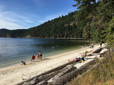
Every year for twenty years we've been coming back to this beach. Maybe not just for the beach, but to the beach. I posted a more thorough description two years ago:
St. Mary Lake: August 2015

It hasn't changed too much in the last twenty years - geomorphologically. What has changed is the demographics - the little children have grown up and gone off to college and rarely make it back. The parents get older. Old folks stop coming. Younger families take their place.

The beach toys get larger and more interesting.

AERIAL VIEW

The swash zone doesn't shift much on this beach over the summer. Afternoon waves from the south try to smooth out whatever perturbations to the small pocket beach have been created with plastic shovels and buckets in the previous 24 hours. Fine sand, coarse sand, and small gravel sort and resort themselves just as on larger, more energetic beaches.

Beach toys left in shallow water influence wave patterns and sometimes leave strange little promontories, even after the temporary breakwater has been removed. 

Without a little new sand now and then and a summertime of human trampling, this little artificial beach would probably revert pretty quickly to reeds. There are too few waves and not enough sediment for beaches to form on their own.


Shell Beach


I missed this and will try to insert into chronological order, which will probably confuse one or two people who actually read these things as they come out. I am also going to keep the entry very short.

Shell Beach is on the northwest side of the tombolo that connects the main part of Montague Harbor Provincial Park (on Galiano Island) to the Gray Peninsula, which would be an island in the absence of the tombolo. There is a small salt marsh and lagoon, and a second, smaller tombolo, on the more sheltered southeastern side of the barrier beach, facing out into Montague Harbor proper.


AERIAL VIEW

The beach itself is rich, and white, in broken shell - thus it's name, I assume. On a summer afternoon it captures the sun and there were no shortage of people enjoying both the beach and the water. My photos actually come from both days of my visit (my base for my two-day exploration of Galiano was a walk-in campsite in the Park). I went for a paddle in the yellow boat on Monday afternoon, watched the sun set from the beach Monday evening, and came back and walked it on Tuesday afternoon, before heading for the Hummingbird Pub for dinner.


Dionisio Point

Dionisio Provincial Park lies at the northern tip of Galiano Island, across Porlier Pass from Valdez Island to the north. Technically, it's marine access only, but with some sleuthing, there are ways to get there without a boat. But don't tell anyone I told you.


There's a beautiful little tombolo connecting the rocky island (which I think is Dionisio Point proper) to the rest of Galiano. Arguably, one might call it a small cuspate foreland that's trying to become a tombolo, since the tip probably goes underwater at many high tides. The southern side of the spit is somewhat sheltered within a rocky bay, so wave exposure may be greater from the north. The northern beach is more fully developed and there were overwash features consistent with north to south wave action. At the same time the bar at the tip also showed signs of current flow from south to north. This would be an interesting spot to watch at a very high tide.


AERIAL VIEW


Interestingly, the northern beach is also much sandier than the southern one, which consists of a fairly uniform gravel lag. I suspect it takes pretty unusual conditions to move material around very much on the south side, whereas the northern beach looked to be much more active.


The sandstones out at the point displayed the neat tafoni weathering that's so characteristic of these Nanamimo Group rocks.

Besides the tombolo, there was a nice little pocket beach around the corner to the northwest. And in between, what was once a substantial Salish village (Quelus', perhaps linked with nearby modern Penalakut Tribe). Here's a link to an NPR story from a few years back: KUOW, 2011.

As is often the case, there is more about some of these Galiano sites on my companion blog:
hshipman: Galiano 2017


Sunday, October 01, 2017

Matthews Beach


This beach at the southern end of Galiano is associated with Mathews Point Regional Park. It's also Shore Access #15, one of many on the island (Capital Regional District: Shore Access).

I've been checking out this beach from the ferry for twenty years as we pass through Active Pass on the way to and from the other islands, but this was my first visit (since it was also my first time on Galiano). The beach usually looks pretty empty, although occasionally I see a few folks who've made it down the steep trail from the road.

AERIAL VIEW

It's a pocket beach - at least it's contained by two rocky headlands with little opportunity for sediment to bypass the bedrock points in the deeper, fast-moving water offshore. But it defies some of the usual stereotypes of pocket beaches.

It's hard to characterize it as swash-aligned since wave action is probably messy and strongly impacted by boat wakes (mainly ferries, but lots of other traffic, too). There's not a lot of fetch across Active Pass's narrow channel and large waves are probably pretty limited. 

Sediment to the beach is provided by eroding bluffs of glacial sediment and possibly from a gully at the west end. The beach generally is sandier at the east end (sand and small gravel); much coarser (large gravel and cobble) at the west. I sort of imagine that any new additions of sediment make up for gradual loss of sediment offshore.

It's a great place to watch ferries - which are frequent.


Morning Beach


I'm playing catch up again. A long road trip intervened, so the next few posts date back to mid-August when we made our annual pilgrimage to Salt Spring Island. This year, I took two days on my own to explore nearby Galiano Island.

Morning Beach, not surprisingly, faces east and on a less hazy day one would probably look directly across the Strait of Georgia at Mount Baker. 

AERIAL VIEW

Like so many pocket beaches in the Gulf Islands, this one is contained by resistant sandstone headlands that reflect the regional strike of the folded rocks (Cretaceous Nanaimo Formation). Sandstone ribs, also on the same strike, break up the beach at the south end. The beach is pretty sandy, which I suppose is some combination of glacial cover and eroded bedrock.