Saturday, October 31, 2009
Weaverling Spit
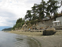
For decades, this beach on the north side of Weaverling Spit has been eroding back into the fill that was placed around the original railroad grade (now the Tommy Thompson bike trail). Pulling back the fill would probably have solved the erosion problem, but would have been hard to sell to the various parties involved. But building a seawall or dumping rock is also hard to sell these days and would have done nothing to restore the beach itself, so folks got together to develop a softer solution.
This nourishment project was completed last month and it seems like a good approach for this site. Sand and gravel was placed on the upper beach, old rock and concrete debris was either carted away or buried, and four anchored log groins (we euphemistically call low groins "drift sills" here - a Wolf Bauer term) were built, although I am not really convinced they are necessary. They add complexity, hard structure, and cost to what might have been a simpler project, but there are also good reasons for including them on some projects.
It will be fun to watch this site evolve - even just over the next few months. Conventional armoring goes in and not much happens visually - after all the purpose of a hard structure is to NOT allow change (many of the impacts of armoring, other than the ones associated with its initial placement, take time to emerge). But nourishment projects are intended to be flexible and like natural beaches, change with storms and seasons. In the process, they tell us much about the factors influencing a site.
Several things will be worth watching. There is already considerable rearrangement of the beach face going on, particularly at the west end where a distinct berm is forming lower on the beach. The stream outfall at the very west end interacts with the new beach and its delta may become a sink for some of the new sediment. There will be some spreading of gravel eastward from the project, although I doubt the volumes will be high. The most important changes will be in the evolution of the berm. Instead of building this project with a natural berm, the sand and gravel were just piled high against the bank. This material will gradually erode and be incorporated into the gravelly foreshore. A berm will slowly develop, allowing logs to accumulate, although logs build up slower on these north-facing shorelines (it's about the wind). The lack of a natural berm and the eroding material from the upper part of the project will keep this from looking like a natural beach for several years, but we should remember that shoreline projects should not be judged over the short-term.
There are some shots from nearby, though not this particular site, at:
Weaverling Spit: September 2009.
And if you want to check out the trail - just note that a fire on the trestle a couple of weeks ago closed the trail east across Fidalgo Bay from Weaverling.
Sunday, October 04, 2009
Whatcom Waterway
Whatcom Creek flows through Bellingham and tumbles down rocky ledges to meet tidewater. I suppose it once flowed from there through a small estuary and then out across a broad intertidal delta into the bay, but now it enters the head of the straightened and dredged waterway and flows through the old Georgia Pacific site before reaching deep water. The mill itself was built on fill over the original tideflats. Some of the inner estuary is being restored, but there's not much evidence left of the stream delta or the original shoreline.
A small pocket beach had formed on the inside of the old log pond at the mill site - confirmation that if you have loose sediment, wave action, and a favorable geometry, beaches can form anywhere. This beach should serve as a useful guide when it comes time to redesign a new shoreline park along here.
New Whatcom
For decades, Bellingham's waterfront was dominated by the Georgia Pacific paper mill, but now the mill has closed and the city has an opportunity to do something new and exciting on its shoreline. But it will take a long time to sort the economics, the priorities, the history, and the toxic residue. Meanwhile, some wonderful decaying industrial architecture remains perched on this huge chunk of shoreline.
Nooksack Delta
The Nooksack River drains a large section of the North Cascades between Mount Baker and Canada and has been carry Cascades dirt into Bellingham Bay for ages. Historically, the Nooksack also drained to Lummi Bay, doing so along the path of what is now the Red River, but that option was foreclosed (a deliberate manipulation) over a hundred years ago. The Nooksack continues to build its delta into the northern part of the Bellingham Bay, with the associated sand flats spreading both east past Marietta (toward Bellingham) and southwest along the Lummi Peninsula. Its delta remains the most natural of all the big river deltas on the eastern shore of the Sound, with multiple, changing distributaries and forested wetlands.
Lummi Shore Drive
Probably the largest and longest erosion control project on Puget Sound in recent years was the construction of this revetment in the late 1990s. The road was too close to the edge of the eroding bluff and sections occasionally caved off - reducing the road to a single lane. Some consideration may have been given to moving the road, but that option didn't get much traction in the face of local interests and funding sources that favor defense rather than avoidance. The road is nice and offers great views across the bay to Bellingham, the Cascades, and Portage and Lummi Islands, but the upper beach is gone forever - although some attempt has been made to maintain it by periodically adding sand and gravel. Unfortunately, that's probably not a terribly sustainable solution over the longer term on a site like this.
Friday, October 02, 2009
Kiket Island
Kiket is not really an island, but a rocky point connected to the rest of North America by a tombolo (as usual, the title of the post links to an aerial view). Maybe it started as a cuspate foreland, a triangle of spits reaching for the island, but ultimately it connected, resulting in a double tombolo and a small tidal lagoon. Flagstaff Island, just west of Kiket, is attached by another smaller tombolo. The beaches on the south side get the brunt of the southerly wave action and trap the big logs. The northern beaches are more protected and the wood that does come ashore doesn’t stay long.
The island includes the remains of the old research lab where UW students sorted through biological data – better to document conditions prior to the construction of a salt water-cooled nuclear power station proposed in the late 1960s (but never built). Now it looks like it will become a park.
Ediz Hook
Ediz Hook began as a graceful spit enclosing Port Angeles Harbor – where native villages dotted the shoreline long before the anchorage was discovered by white folks. But spits move and maybe they move faster when their sediment supply is cut off. Some of gravel that formed Ediz Hook came from the Elwha River and is now stuck behind the dams or in the lower river, waiting for a flood to wash it to the sea where the waves can turn it into a beach. Some of the gravel that formed Ediz Hook came from the erosion of bluffs to the west, bluffs now stabilized by the riprapped pipeline that brings water to the mill and to town. Restoring sediment sources won’t cause Ediz Hook to build back again, but it may reduce the frequency with which the Corps needs to feed cobble to the spit to keep its elegant revetment from sliding into the Strait.
This is one of the nicest revetments on Puget Sound – big rock, securely placed on top of several miles of beach. The inside of Ediz Hook was probably once a wonderful beach, too, but a long history of log storage and marine industry have left eroding banks of fill between small pockets of sand and gravel.
Dry Creek
A gravel berm dams the mouth of Dry Creek – not that there is any water in Dry Creek right now. Sometimes the stream really does flow and breaks through the berm, but the waves just build it back. The seawall at the old landfill is impressive, although the beach in front of it continues to erode away. I suppose the erosion may be faster than normal these days – after all, the sediment that is supposed to be here may all be stuck in that big plug of gravel ¾ mile updrift (Elwha, from this summer).
Dry Creek (March 2008)
Clallam Bay
It’s been a little over three years since I’ve been out here (Clallam Bay, 2006). The Clallam River is still being unclear about its plans and the pedestrian bridge in the park is still left wondering. Nature isn't always convenient or predictable - I guess that's the point.
Sekiu
The towns of Sekiu and Clallam Bay sit in a small bay about 30 miles inside the entrance of the Strait of Juan de Fuca. The configuration of the bay gives rise to two large crescent-shaped beaches – basically pocket beaches – although Clallam Bay on the east is complicated by the presence, and fickleness, of the Clallam River.
This is the beach at the western end, extending from the Coho Marina west to the riprap, fill, and rocky shoreline of Sekiu itself. There used to be a railroad along the back of the beach although what’s left of its grade is gradually eroding away. This beautiful gravel beach gets muted swell from the open Pacific and occasional strong blasts from the northeast.
Mission Beach
I’m sure this is a wonderful place to enjoy summer low tides – warm water rising over broad sandy flats – but the homes are all too close – to each other, to the water, and to the bottom of the bluff (which occasionally collapses behind them). The back-beach is long gone, although there’s a remarkable stretch of wide beach and undeveloped bluffs to the south.
Spee-bi-dah
The Tulalip shoreline is a mix of good and bad. The small low-lying communities – mainly private inholdings -- are built on the beach, on the backshore marshes, and across the stream mouths, and are marked by long lines of bulkheads (most along here are timber soldier-pile walls, reflecting a local abundance of logs and the standard design of the local contractor). But where the bluffs rise in height, there are long stretches of beautiful shoreline with extensive forest stretching inland from their crest. There are several reaches along here that probably look much as they did 150 years ago absent some of the largest trees and the chain-sawed ends of the abundant drift logs.
Hermosa Point
Tulalip Bay occupies a big bowl in the glacial landscape – but its rim is low enough on the southwestern side to let Puget Sound spill in (or Tulalip Bay to spill out?). Hermosa Point marks the northern entrance to the bay. Waves from the south have eroded the point for centuries, feeding sediment into both the bay and along the coast to the north. But there’s not much sediment to feed. Erosion of the glacial till has left a coarse armored lag on the surface of the beach in front of the point itself and bulkheads have limited erosion of the glacial drift in the 60’ bluff. The older pre-Vashon sediments that crop out on the lower bluff north of the point are also exposed on the sediment-starved beach in big sweeping arcs.
Merrill and Ring Creek
Named after one of the region’s timber giants, this is one of many small streams that drain to the “Great Northern” shoreline between Seattle and Everett. It is also one of the very few of them to have a delta with dry land and forest on the seaward side of the railroad tracks. Picnic Point is another. The stream emerges from its culvert, across this small patch of trees and gravel, and then gets detoured behind a small spit before being allowed to drain across the beach at the east end of the point. Like the other stream mouths on this north-facing shoreline between Mukilteo and Everett, the stream has a large intertidal delta – this is probably tied to the lower wave energy (northerlies can be vicious, but are rare) which may allow this kind of feature to persist.