skip to main |
skip to sidebar
The Ocean Beach pier marks a distinct change in the coastline - the steep bluffs of Sunset Cliffs to the south, the wide open beaches that shelter Mission Bay to the north. Just north of Ocean Beach, jetties mark the mouth of the San Diego River and the adjacent mouth of Mission Bay.
 Artificial berms, almost pseudo dunes, are commonly employed along this coast. My understanding is that these are basically storm-protection, since even a little elevation and sediment can provide at least some short-term protection to the low lying areas behind them during high water events. I know quite a bit has been written about these, but this was my first introduction to them on this scale.
 Dog Beach is the spit or sand bar that largely fills the jettied mouth of the river (check the aerial view). I suppose this all gets flushed out during big flood events, but probably restablishes fairly quickly.
Mission Bay used to be called False Bay and would have been the natural lagoon or estuary at the mouth of the river, but this whole system has been reshaped and replumbed and bears little resemblance to what Cabrillo encountered back in 1542.

 From the wide sandy beaches of Coronado to the steep sandstone cliffs north of Point Loma - quite the contrast. The beaches along here are sporadic pockets of sand and some cobble ramps pushed of against the base of the cliffs. The cliffs themselves consist of Pleistocene sandstones overlying much older Cretaceous ones.
AERIAL VIEW
 Sunset Cliffs Boulevard runs along the top of the bluffs and the clifftop is all part of the San Diego's Sunset Cliffs Natural Park. Like most of the bluffs I saw in San Diego County, these have taken quite a beating from foot traffic and runoff and much of the upper bluff erosion is probably unrelated to the waves pounding at the base - although ultimately, I assume those are what control the long-term retreat of this shoreline.

 The Silver Strand is the beach that lies along the long spit that forms San Diego Bay. It extends from Imperial Beach on the south to the harbor entrance at the north.
Because of the sheltering effect of Point Loma, sediment transport along this beach is northerly (drift is generally to the south on the southern California coast).
AERIAL VIEW
 The original spit was narrow and subject to overwash into the bay, but nourishment has resulted in a much more robust feature, albeit one with a high long-term maintenance cost (and a cost that may increase disproportionately with rising sea levels).
 Besides the large Zuninga jetty at the north end, there are numerous other structures, including a couple of groins in Imperial Beach and the old rock structure(s) in front of the Hotel del Coronado, which I noted in an earlier post (Coronado). There is a large state beach (Silver Strand, of course), the Navy's Amphibious Base (they were doing a beach landing when I drove past), the highrises just south of the old hotel (the whole development is pushed much too far seaward), and the big Naval Air Station at North Island.

 Most of Imperial Beach lies on slightly raised ground (a low terrace?) between the Tijuana River Estuary on the south and the lower Otay River Valley on the north, which flows into the bottom of San Diego Bay.
AERIAL VIEW
But not all of it - some of it is built right on the beach. You get a sense of this looking at the south end of Seacoast Drive. The homes are practically in the ocean. Or they would be if SANDAG didn't pump large amounts of sand onto this beach now and then.
 It's a good thing storm surges and tsunami aren't too common here or these places would all be a marker layer of coarse sediment in Oneonta Slough - the northern arm of the Tijuana Estuary that lies right behind them.
Coronado is built on land that was once two low islands, possibly overwash deposits, at the northern tip of the long sand spit that forms San Diego Harbor. Now, consolidated into a single island, Coronado is home to a Navy base, a residential community, and a grand old hotel.
 The Hotel del Coronado has been hosting the rich and famous since the late 1800s. It's built in a classic Victorian style and is reportedly the second largest wood structure in the U.S.
AERIAL VIEW

 Old photos show waves eroding the shoreline right up to the resort's western edge. Starting more than 100 years ago, numerous attempts were made to protect it, and some of the big pile of rock on the beach out front is what's left behind. But in the end, it's been saved by the same thing that has saved most of the other shoreline development in San Diego County - beach nourishment.
The (currently) wide beaches at Imperial Beach, the Silver Strand, and Coronado, right up to the large Zuniga Jetty at the very north end, all have benefited from sand dredged from the harbor or brought in from offshore. More on this in subsequent posts.
In hindsight, I realize that the beer I enjoyed at the Hotel's pricey bar that evening was a fitting celebration of this becoming the 600th post to Gravel Beach! It began back in December 2005, and some of the earliest posts were from Southern California.
 This is the first of what will be a dozen or so posts from San Diego, the consequence of two days tucked onto the end of a four day estuaries conference - and a few hours before.
Like many urban harbors, San Diego's modern bayfront in no way follows the original shoreline of mud flats, salt pans, low energy beaches, and estuarine marsh, having been dredged and filled into new shapes that make building ports, developing land easier, and parking aircraft carriers easier. The resulting edge is steep and extends into deeper water, so the reclaimed land will erode if left to its own.

 I guess this is why riprap was invented. Aesthetics are tricky, since opinions depend on the context and on the beholder as much as the actual revetment. I find some applications appealing, others horrible. I understand its practical benefits. But some of my gripes are it's ubiquitousness, the lack of imagination it often reflects, its contrast to the native ecological setting, and its impact on people's ability to actually interact with the water.
 AERIAL VIEW
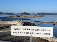
My visit to Whiffen Spit two weeks ago had me thinking a lot about Ala Spit, and since I was in the area for meetings and other site visits, I figured it was worth checking out Ala while the tide was still pretty high and I still had a little daylight left. The tide was a little above MHHW and flowing rapidly into the lagoon across the neck of the spit.
Gravel Beach: Ala Spit (December 2011 -- from there you can link back to earlier posts)
 This site remains one of the more interesting beach restoration stories of the last few years and I suspect is trying to teach us lessons that, if we pay attention, will help us all on future projects.
One of the lessons - the more obvious one - is that beaches can suffer from a number of ills and that successful restoration must address, or at least carefully consider, all of them. Sometimes the challenge is figuring out which problems are most serious and which are secondary.
I think the more complex lesson is about restoring dynamic systems - especially after several decades have gone past. Removing a stressor does not necessarily take you back to where you would have been had the stressor never been applied. I'm trying to figure out how to use the word "hysteresis" here - because I think it is important. But I need to work longer on this argument than I have time for now -- and there will undoubtedly be other chances!
Google Maps: AERIAL VIEW

 It's not hard to figure out how this place got its name, although I'm sure the Swinomish have more interesting words for it. Lone Tree Point is trying hard to be a tombolo - but lacks enough sediment to do it very well. What sand and gravel there is has built a broad, low bar out to the rocky islet, and then spread out northward as a spit that forms a lagoon across the mouth of the small creek that winds down through the Thousand Trails campground.
Google Maps: AERIAL VIEW
The geology is messy here and the bedrock forms irregular shoals and reefs offshore. The strange tilted beaches I noted on Hope Island last year are a short distance away across a narrow channel (Hope Island: May 2012).
Lone Tree provides an interesting contrast to other small barrier beaches in the area, such as the tombolos at Kiket Island (Kukutali Preserve) and the beach at Ala Spit (also the subject of the next post). The differences are partly due to the arrangement of the bedrock geology and partly due to the availability of beach sediment, among other things.


 Artificial berms, almost pseudo dunes, are commonly employed along this coast. My understanding is that these are basically storm-protection, since even a little elevation and sediment can provide at least some short-term protection to the low lying areas behind them during high water events. I know quite a bit has been written about these, but this was my first introduction to them on this scale.
 Dog Beach is the spit or sand bar that largely fills the jettied mouth of the river (check the aerial view). I suppose this all gets flushed out during big flood events, but probably restablishes fairly quickly.


