skip to main |
skip to sidebar
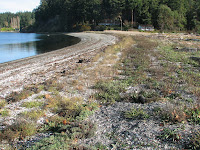
This is another site where an old bulkhead - or perhaps more accurately, several old bulkheads and a lot of rubble - have recently been removed. A complex partnership of many different people came together to make this project happen.
This is a relatively low energy shoreline - wave action fades quickly entering the bay and the last real beach ends just short of this site. That doesn't mean that the banks aren't subject to erosion, but the rates are low and the site is developed in such a way that minor erosion is not a problem. Over time, some of the bank will crumble and a few trees will fall, but the resulting shoreline will be richer and more natural. Ironically, it looks like much of the past erosion is of fill material that was placed over the natural bank - which is so often the case.
This is a concept that could apply to many, many sites in Puget Sound and maybe some more examples like this one will help show folks that unarmored shorelines can provide as many benefits as those that are buried in rock and concrete.
The northern Kitsap Peninsula is a reminder of the diversity of Puget Sound's coastline. Most of the shore consists of bluffs built of glacial and other late Pleistocene sediments, but variation in the geologic details, the topography, the exposure, and the nature of the beach make simple generalizations tough.
We covered a lot of shoreline and I've included several different locations in this single post - the bold heading links to a map.
 Foulweather Bluff. These high bluffs at the northern tip of the Kitsap Peninsula feed sediment southward to form an elegant spit on hood Canal on the west side and the extensive barriers at Skunk Bay, Hansville, Point No Point on the east. The highest bluffs were riprapped ages ago. The eastern tip of Foulweather Bluff is lower, but unbulkheaded. It is eroding impressively - though any homes are well back (measured in many centuries) from the edge. At least there's still some sediment feeding the beaches to the east.


Kingston. Parts of the shoreline north of Kingston were the site of big deep-seated landslides in the 1970s (and probably every few decades for millennia before that - we just didn't notice).


North of Apple Cove Point. Apple Cove Point itself is a barrier sporting many large homes at sea level (20th century sea level, that is), but the bluffs to the north of it are the kind of mess only a geologist can appreciate. Very large landslides in the late 1990s impacted several proposed building sites - better the slopes failed before the homes were built than after!


Indianola to Point Jefferson. Beautiful south-facing bluffs, though lots of variety between the high bluffs in Indianola and the lower till bluffs east of Doe Kag Wats (the beautiful barrier estuary in the middle of this reach).


Seabold. These bluffs on the northwest side of Bainbridge are among the few stretches of high bluff on the island not buttressed in rock. Classic Puget Sound bluffs - heavily forested, slow but not negligible erosion, subject to shallow slides and occasional larger slumps, and lined with big houses and nervous property owners. But the beaches are what they are supposed to be - lots of sediment, lots of wood, looking like a shoreline, not a canal. Too bad many people's view of the shoreline environment is a view, not the environment. The trees go down and the seawalls go up.
 Brownsville. Really large landslides on Puget Sound are unusual. This one occurred around 1980 and is now marked by a monolithic forest of 28-year old alder. Large snags still protrude from the beach far out from the pre-slide shoreline and there is an awful lot of sand in front of this highly unstable stretch of shoreline. Other big landslides like this one include Woodway (Edmonds), Possession (South Whidbey), and Lone Rock (Seabeck). These differ from the large, slow moving, deep-seated slides of which we have so many, but which aren't quite so catastrophic.

 Point Bolin. When I visited this site two years ago, I remarked on the unusual concrete pipe bulkhead (Point Bolin, July, 2006). Since then, folks felt compelled to replace it with something a bit newer, and a lot more generic.
 Also from November. Battle Point is a neat little cuspate spit and lagoon on the western side of Bainbridge Island. The inlet is on the south shore, while the northern limb shows some signs of continued accretion. Note the newer berm in the upper photo. Erosion of the inlet exposes peat from an earlier incarnation of the lagoon and marsh.


