skip to main |
skip to sidebar
Much of Thunder Bay's waterfront is industrial or otherwise difficult to access. Marina Park in the north part of downtown was nice, but all riprap. Chippewa Park south of town has two beaches. The main swimming beach (I guess some people swim in Lake Superior) is a sandy curve along a small cove sheltered by a rock breakwater.
The pictures here are of Sandy Beach, which is more exposed than Chippewa's swimming beach and lies just to the south. It's the only sand along this stretch, which made me wonder if it could have been trucked in. The beach is broken into several small curves by rock groins.
This is a uneven stretch of coastline. The adjacent shores are ragged (see aerial below), suggesting that the geology may be irregular (maybe piles of glacial cobble in otherwise soft material, or resistant ledges in softer bedrock). Or perhaps, the shoreline has simply eroded for decades and those little points are old rock groins, sort of like the ones on this beach, but without the sand in between. I have no idea and only noticed the pattern once I was back in Seattle.
AERIAL VIEW
 This beach must be icebound all winter - so wave action is probably most significant in fall before it freezes over. I don't have enough experience in these settings to know what peculiar things moving ice does to beach gravel, although I assume under certain conditions it can leave some pretty cool landforms - ice thrusts, rafted pebbles, ice scour.
Thunder Bay at hshipman. As usual, my other blog parallels this one, but instead of rambling commentary about beaches, you get rambling commentary about other stuff. Sometimes it includes a little non-beach geology; sometimes it just has pictures of food.


The northern shore of lake Erie (Google Maps) is punctuated by three elegant landforms. The location of each may be determined by glacial features like moraines, but the shape of each is all about wind and waves and moving sediment. There are good bathymetric maps and geologic explanations of Lake Erie at NOAA's NGDC.
Long Point is a spit, neither a simple nor a small one.
Point aux Pins (Rondeau Provincial Park) is an arcuate promontory that might be categorized as a recurved or cuspate spit. Its southeastern shore is composed of a beautiful series of accreted beach ridges, while its western shore is somewhat more tenuous. There is a big offset in the shoreline at the jetties at Erieau and the map on the wall at the Eau Buoy Cafe showed that in 1868 the natural opening was much larger and located pretty much where the town is today.
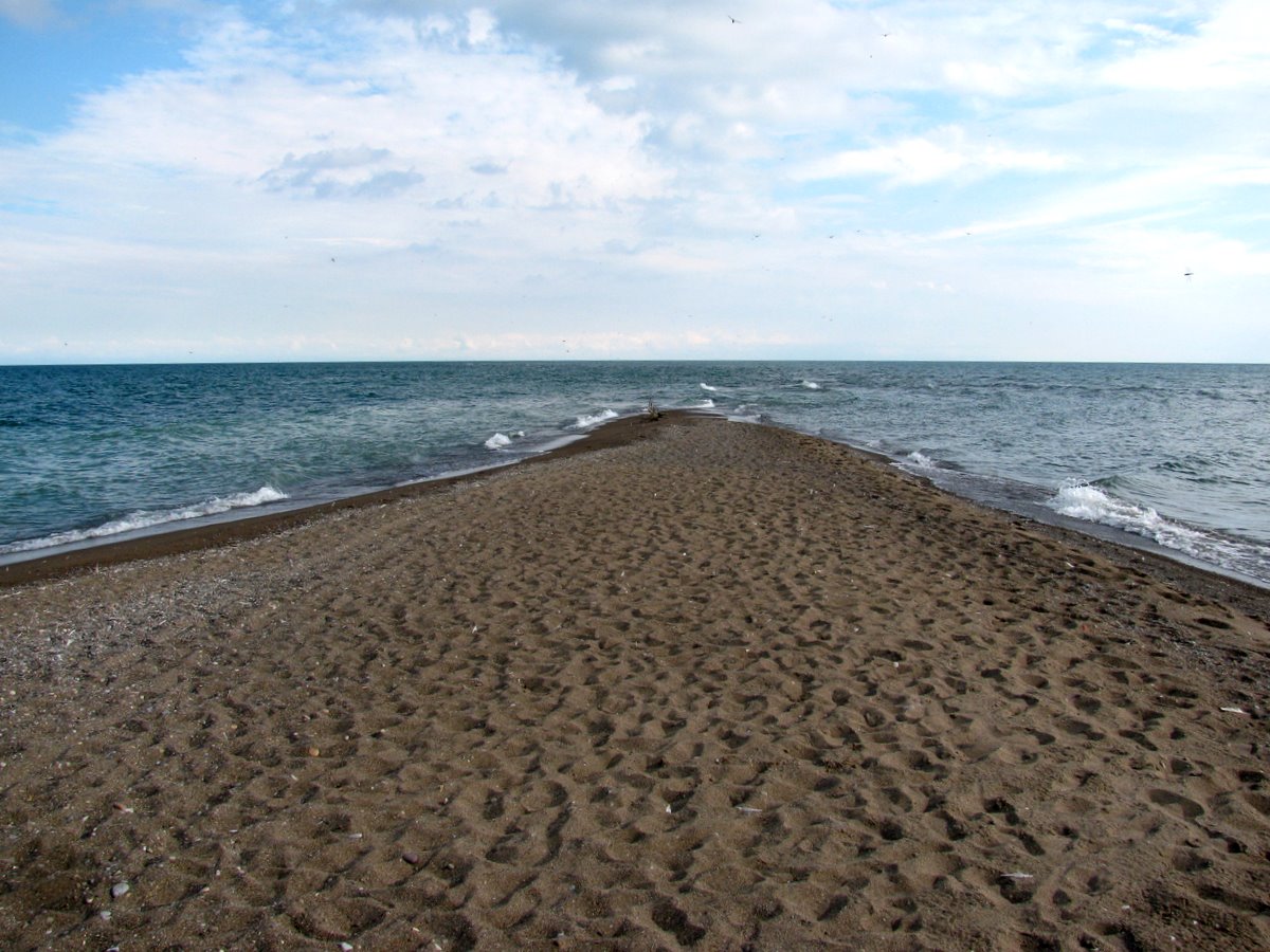
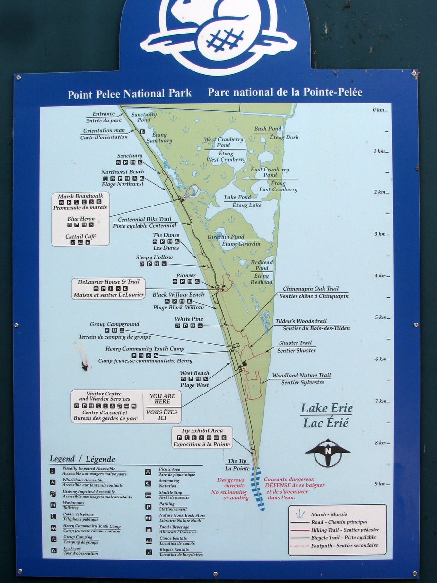
Point Pelee, where all of the these photos are from, is a large cuspate foreland, tapering to a slender point. It has lost ground, or at least changed shape, over time, making the riprap on the west side of the tip seem both unfortunate and sort of futile. The sinuous tip vanished southward under the waves, tempting me to wade out farther, but the biting flies argued against it.
Point Pelee is the southernmost point in mainland Canada. The country's true southernmost point is a very similar looking spit at the southern tip of Pelee Island, maybe 25 km south of here.


This is a more geographically general post than most, since my goal was simply to capture several shots taken as we traveled between the Cape Rondeau area and the western end of the lake. This shoreline consists mainly of bluffs, many of clay or silt, but there are also low beaches, including the large barriers that have formed at Point aux Pins and Point Pelee.
The geography of this shoreline appears to be controlled by larger glacial features and sediment variability, subsequently reshaped by Holocene coastal processes. Humans have left their mark, too, with jetties, lots of groins, and a mish mash of armoring, at least locally. Most of the shoreline development is on the low beaches, probably because the bluffs are eroding quickly enough to discourage building and because the demand for Lake Erie view property isn't the same as on Puget Sound.
The timber groins are at Erie Beach?, just west of Erieau (Aerial).
The bluffs are at Point Alma (Aerial).
The sheetpile groins are on the west side of Point Pelee, near Seacliffe. (Aerial)


Bluffers Park is typical of the large multi-tentacled lake fills found along the greater Toronto shoreline (Humber Bay Park is another). Built as parks, these artificial shorelines are part jetty, part spit, part landfill. Their outer edges consists of revetments, rock headlands, and pocket beaches. They enclose marinas, lagoons, ponds, and marshes. Some of the wetlands have been retrofitted to filter storm water. These are entirely created features and they in no way maintain the natural geological (or ecological, one assumes) processes that originally characterized these shorelines, but they are an interesting approach to creating waterfront access, enhancing habitat, and preventing the historic erosion that would have threatened a growing metropolis.
The Michigan Basin is underlain by a thick series of very old rocks, including layers of carbonate rocks deposited in warm seas over 400 million years ago. These sedimentary rocks are basically limestone, but the addition of magnesium has turned the calcite to dolomite and the resulting rock to dolostone. These resistant layers are deepest under Michigan, but like a large saucer, tilt gradually upwards until they break the surface in a large arc around the Great Lakes. These rocks form the Niagara Escarpment, a low hogsback (or cuesta) with a gradual slope on the inner (Michigan) side and a steeper cliff or bluff on the outward facing edge.
The escarpment runs from western New York State north into Canada, around the western end of Lake Ontario, and north across the farmland of southern Ontario. It forms the Bruce Peninsula and Manitoulin Island, between Lake Huron and Georgian Bay, and then sweeps across the upper peninsula of Michigan before heading south to form the Dore Peninsula and Green Bay in Wisconsin (thus the geologic similarity of the Buffalo Bills and the Green Bay Packers?). Streams flowing across the escarpment form cascades, Niagara Falls being the most obvious.


 This beach must be icebound all winter - so wave action is probably most significant in fall before it freezes over. I don't have enough experience in these settings to know what peculiar things moving ice does to beach gravel, although I assume under certain conditions it can leave some pretty cool landforms - ice thrusts, rafted pebbles, ice scour.