Showing posts with label hood canal. Show all posts

Wednesday, May 11, 2016

Salsbury Point


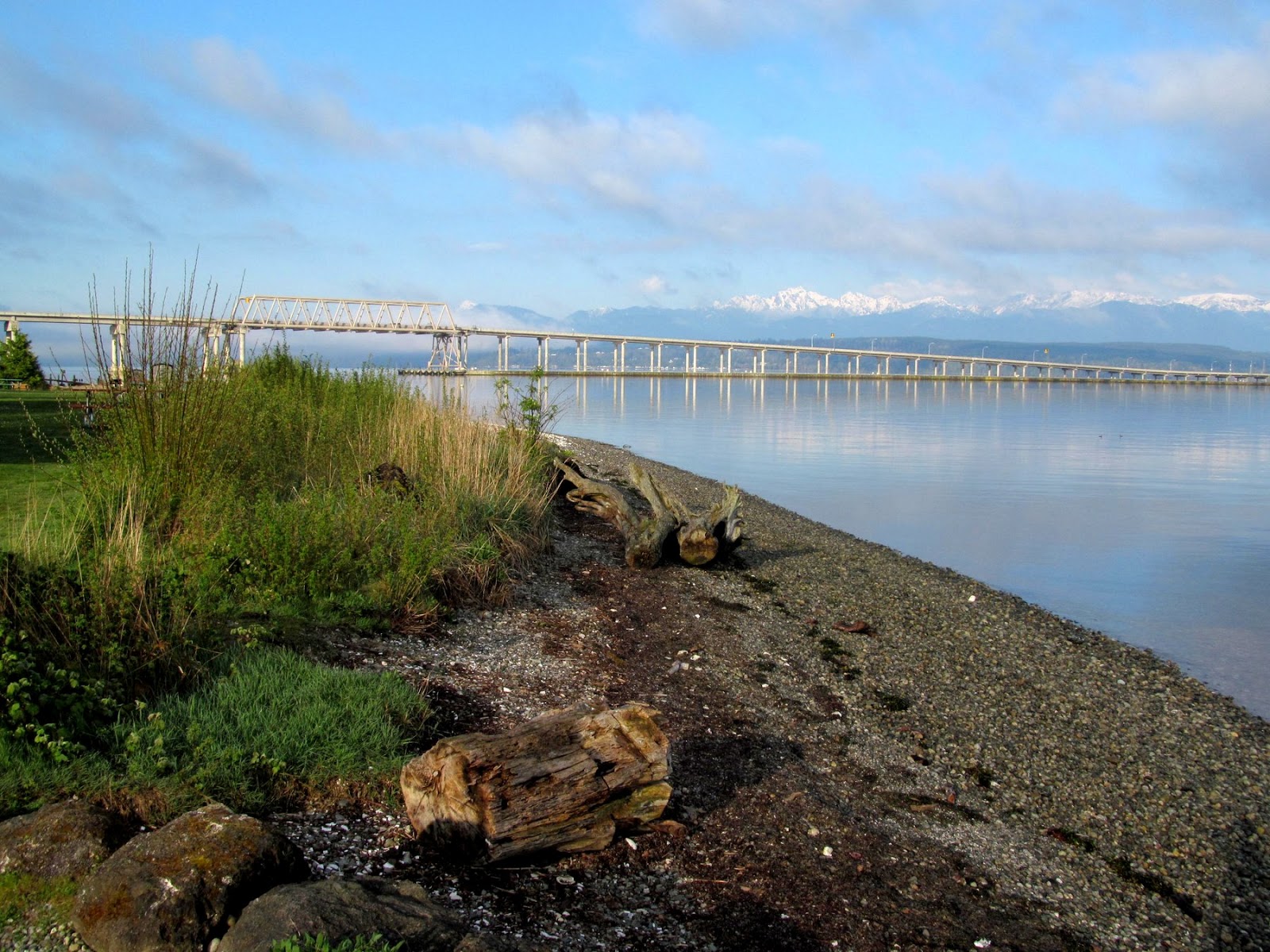
In the fall of 1995, Kitsap County Parks removed the old riprap and nourished the beach. And it's still doing remarkably well.

It's a difficult site - the lagoon was filled, the beach pushed out, and the coastal regime altered because of the boat ramps and because the floating bridge has cut off much of the southerly wave action (which would have continued to deliver sediment). The original plan was just to rebuild a nicer rock bulkhead, but a habitat biologist pushed back, suggesting something softer. And County Parks staff were willing to listen. A geologist with the state (much younger then) helped them sketch out some ideas and cross-sections, based on experience with some of Wolf Bauer's designs.

Beach east of the boat ramps
Although I was pretty confident the project would work, I never would have expected it to go 20 years without a little assistance. The underlying erosion problem remains and the beach has gradually retreated into the backshore created in 1995. The backshore is a little too high, so it doesn't get overtopped, and therefore supports upland vegetation better than beach grass. An old drain pipe has gradually been exposed and dribbles rusty water onto the beach.

Healthy beach at south end of park
Previous post:  Salsbury Point: 2013

I think some adaptive management is due. Before someone gets surprised and does something dumb. I understand there is talk of doing some work on the boat ramp(s) - maybe that will be a chance to look at some options.

AERIAL VIEW

Of course, there's still a difficult stretch between the main park and the ramp - I think it's where electric cables head out under the canal. It's oriented obliquely to the waves and has no sediment - which presents a real challenge.


Monday, February 29, 2016

Nellita Creek


It's getting harder and harder to imagine what this site looked like just six years ago - when 400' of timber bulkhead marked the shoreline and the channelized creek flowed over the bulkhead in a flume. The small estuary that was created behind the old bulkhead line is smaller than it started, since a lot of sediment came down the stream in the first couple of years, but it still represents new wetland, brackish marsh, and low gradient stream habitat. Salt marsh is establishing near the creek mouth and the forest is rapidly taking over the rest of the site.

AERIAL VIEW

The beach still seems to be naturally starved of sediment to me, and the restored spit has a strange appearance (look at the aerial), but all the pieces are in place and with time they will sort themselves into something that looks like it always belonged.

This is my fourth visit - you've got to go back to the 2009 post to see what it looked like before:

Nellita Creek: October 2011
Nellita: January 2010
S. of Frenchman's Cove: May 2009

By the way, this is part of the Stavis NRCA (WDNR's Natural Resource Conservation Area), since I realized I had never used that name in these posts. I'm still not even sure that Nellita Creek is really the correct name - or if it is, that I've spelled it right!


Lynch Cove


I'm not really sure what happened, but this is the first post in three months. The first since that beautiful day on Whidbey right after Thanksgiving. It's not that I haven't been to the beach, although those few trips have tended to be pretty gray and uninspiring. And it's not that there haven't been some interesting stories, but maybe the narrative and the photos weren't lining up. Or maybe I've been preoccupied with other stuff and let things slide! The next few posts will be a ragged attempt to get back on track.

We'll start here in Belfair, at the far tip of Hood Canal, way back in mid-December. The site isn't even a beach - too little sand and gravel, too few waves. But it's a neat salt marsh restoration project and has been in the on-deck pile ever since.

The large marsh complex at the mouth of the Union River is not unlike others found at the heads of inlets (Discovery Bay, Totten Inlet, and so forth). I guess on the delta ternary, it's mainly "tide", with a little "river," and almost no "waves." Like many historically drained ("pasturized?") marshes, this was an opportunity to pull out some dikes and allow the tides and the salt water back in. As elsewhere, there were challenges in deciding how much dike to remove, whether new dikes have to be built landward, how to maintain public access (there's a wonderful trail and boardwalk system here), and whether to recreate channels or let them figure themselves out. The current Google Maps aerial below shows the site under construction - a more recent image would show a remarkable network of s-shaped channels.

AERIAL VIEW

One thing that makes this marsh interesting to me is that its been subject to significant elevation changes - possibly rapid uplift associated with earthquakes, followed by more gradual subsidence. The story has been best worked out here in the marshes of Lynch Cove, but I suspect the story also helps explain the terraced appearance of much of the south arm of Hood Canal.


Thursday, October 29, 2015

Tarboo Bay


Tarboo Bay is located at the northernmost end of much larger Dabob Bay, sheltered behind an elegant series of spits.

AERIAL VIEW

This small site at the very head of the bay was recently restored by the Northwest Watershed Institute, the local organization that has spearheaded so much restoration work in this area. A year ago, there was a building built on piles over the water and an old timber bulkhead, but the structures have since been removed and the bank and the old driveway have been replanted with native trees and shrubs. In a few years, it will blend perfectly with the adjacent landscape.

The now unprotected bank is eroding, supplying coarse gravel to build a small beach and sand that is reshaping a tiny beach nearby. It will be interesting to see how long it takes for the marsh to recolonize the beach surface - wave energy is sufficiently low here that vegetation is the natural end point rather than a beach, something seen by looking at the adjacent shoreline to the north where marsh grass obscures the gravel beach beneath.


Dabob Bay


I don't get to this remote corner of Puget Sound very often, and not many others do either, so it remains a relatively pristine landscape. The last time I visited was 8 years ago, on a day a little bleaker than this one (Broad Spit: October 2007).

AERIAL VIEW

One of the things that struck me on that trip was how difficult it is to find small stream mouths on Puget Sound - even way back here - that haven't been significantly modified. They were the natural place to sluice logs out of the hills, to homestead, to construct shingle mills and oyster farms, and later, to build vacation homes. Valley bottoms were cleared, streams channels were relocated, and spits and small estuaries were buried. Reference sites for restoration projects are hard to find.

Once riprap, now a beach
Local groups, along with DNR and the Nature Conservancy and others, have patched together a large mosaic of forested uplands, beaches, and tidelands here in northern Dabob Bay and are in the process of restoring the more disturbed sites. Some work has already been done here - a bulkhead was removed and some roads were taken out from an earlier development effort on the hillside. But now there's an opportunity to do more and I'm looking forward to coming back in a few years to see what it looks like.


Thursday, May 02, 2013

Salsbury Point


I stop briefly at this Kitsap County Park almost every time I drive to Jefferson County or elsewhere on the Peninsula, since it's right off the main road just before you get to the Hood Canal Bridge.  In the mid-1990s, I came here even more often, sometimes on weekends with a small child in tow, to informally monitor the beach after the old riprap was pulled out and replaced with a small gravel beach.  It's done remarkably well, given the nourishment occurred seventeen years ago (October, 1995), but the beach face has gradually eroded landward and some serious thought should be given to adding some more gravel, tweaking the backshore vegetation (maybe lowering the backshore six inches or so), and dealing with the old drain pipe that's seeping onto the beach.  A solution for the failing rockwork at the eastern end would also be nice, but trickier.

AERIAL VIEW


As mentioned previously, Salsbury Point has suffered a number of insults - the floating bridge has modified the wave regime, perhaps cutting off the supply of sediment from the south. The boat ramps have isolated it from the beach to the east.  And of course, this was once a narrow recurved spit with a small tidal lagoon behind it, although one would is hard pressed to see much evidence of that today!

Previous Mentions:  Salsbury Point 

Hood Canal Bridge


The western end of the Hood Canal  bridge is built on fill and extends across the beach.  The result has been some fairly obvious changes to sediment transport and beach processes both north and south of the approach (Shine Tidelands 2007, Termination Point 2011).  But here on the eastern end, the bridge passes over the beach and any effects on the beach are less obvious.  I've speculated a little about the possible effect of the bridge on wave action north of the bridge in an earlier post on Salsbury Point (2007).

AERIAL VIEW

The beach continues unbroken beneath the bridge, although the character of the low tide terrace changes significantly along here and there is also a small accretional bulge in the upper beach a short distance north of the bridge.  The low tide beach is likely a fairly robust feature of the landscape - it would be very difficult, short of dredging, to change the width of the low tide terrace very much.  But the upper beach is a different story and I've always wondered whether the accretion might be in part to the falling off of wave action from the north due to the bridge itself.  There was already a fairly wide beach here -- and a much older dock -- before the bridge was built in 1961, so this would require some serious sleuthing to sort out.

Under the bridge, WashDOT (I assume) has placed a series of nicely arranged logs at the base of the slope. This is one of numerous examples on Puget Sound where large wood is being used in a naturalistic way as erosion control. I'm often pretty skeptical of such approaches (long story, but sometimes I think they are neither very effective nor very natural), but in this case it's an interesting idea.  Admittedly, I'm not sure how much of an erosion problem there was to start with at this location.

Saturday, October 29, 2011

Nellita Creek


I last visited this site in January 2010, only a few months after the seawall and the fill were removed and the stream mouth estuary was re-excavated.  Now the site has had enough time for the vegetation to really begin to take hold.  The stream has deposited a significant volume of sediment in the upper portion of the lagoon and this area is now high enough for alder to establish.  The lower portions of the estuary are giving rise to various salt marsh plants.  The mouth of the estuary is probably still trying to figure out how to balance the stream and the daily ebbing and flooding of the tides.  On the other hand, I guess the mouths of estuaries are always trying to sort this out.


The spit itself is a pretty uneven feature.  The beachface is marked by two distinct humps, perhaps an artifact of the original shoreline shape or perhaps the coarse-grained fans of earlier stream mouths.  The restored spit has a low point in the berm that has been overtopped.  Eventually, I expect the spit will even out a little bit, but there's not a lot of beach sediment and not a lot of wave action to move it around, so this process will be slow.


Monday, May 09, 2011

Termination Point


The big landslides at Termination Point used to feed the beaches northeastward towards Shine Tidelands and Bywater Bay, but the embankment that supports the west end of the Hood Canal floating bridge cuts across the base of the old spit. This starves the beach at Shine Tidelands, resulting in coarse cobble and an eroding berm. But because the bridge approach acts like a big groin, it traps sediment on the south side and results in a beautiful little swash-aligned pocket beach.

Thursday, October 07, 2010

Twanoh State Park


Twanoh State Park is perched on the delta of Twanoh Creek, along the south shore of Hood Canal. The shoreline of this part of Hood Canal (not really a canal) is heavily built with homes, perhaps obscuring an interesting geologic history, since they may be built on a raised terrace resulting from late Holocene earthquakes. Various characteristics of this shoreline suggest that it was elevated at some point, or points, in the past.


The parking lot and boat ramp on the west side are built on top of the original beach (if there ever was much of one) and the stream delta. What isn't covered by pavement is covered with broken riprap, but fortunately today's tide kept that out of sight. There's a small beach, with wrack lines of oyster shell and leaves and eelgrass, just west of the ramp (and featured in one of the first posts in this blog, way back in late 2005 -- Hood Canal).

On the east side, there's a nice gravel beach swash-aligned with the maximum fetch from the east, and a long narrow lagoon that's been modified and plumbed for children (the old maps show with an inlet near the tip of the point). Discussions today were around what might be done to improve the ecology without jeopardizing either the recreational uses or the 1930s Civilian Conservation Corps landscape and historic stone structures.

Sunday, January 24, 2010

Nellita


Saturday afternoon - D needed time behind the wheel and I had been itching to visit this site for two months. Tom and Kathy were at the site and gave us the tour, helping us pick our way through thousands of new plantings.

This site is very different now than when I visited last May (South of Frenchman's Cove).
The 400' bulkhead that used to define the shoreline has been removed and a low log-covered spit marks its location and encloses the new lagoon. Many thousands of yards of fill have been removed. The stream has been given a new, more natural channel, amidst lots of big logs and root wads. Instead of flowing over the edge of the bulkhead in a flume, it runs into the newly created lagoon and then out into Hood Canal across a rapidly reforming fan.

We don't know just what this place looked like 150 years ago, but we certainly know something about what parts were probably there and what the processes were that shaped those parts. The folks who put this project together put the basic pieces in place and gave them the ability to move. Now it just requires time. The plants will grow, the logs will move around, the dirt will erode in some places and deposit in others. The geometry will look different in 10 years, but it will look real.

It is rare to have an opportunity to completely restore a place. Check out the aerial view linked to the title of this post. Then check it again a couple years when they've updated those air photos.

Tuesday, May 26, 2009

Boyce Creek


This place has several names, but it's basically where Boyce Creek enters Hood Canal. On the maps it is labeled Frenchman's Cove, but the new Kitsap County Reserve is called Guillemot Cove.

This is one of those rare stream mouths that is still in good shape and provides some clues for restoring other streams in the area. The stream valley was originally graded to a lower sea level, but was subsequently flooded by rising water and now forms a nice example of a barrier estuary, with a tidal wetland sheltered behind an asymmetric pair of barrier spits. The shape and orientation (and relative volume of longshore drift) of this shoreline means that the spit on the south is better developed, whereas the spit on the north is little more than a bulge of gravel and sand.

At very high tides, both fluvial and coastal sediment may wind up being deposited on the marsh surface, but the sink for most of the sediment is the broad intertidal delta. These features, which are common on the Sound, are somewhat a blend of deltas and alluvial fans. Probably depends on what the tide is. During today's -3.8? foot tide, it was clearly more of the latter.