Tuesday, June 21, 2011

Friday Harbor


The University of Washington's Friday Harbor Laboratory has been perched here on the point north of the town for most of the last century. The research focus was historically more on marine biology and rocky coastlines than on beaches, which makes sense given its location.

The lab, like other water-oriented developments, has grown somewhat organically along the edge of the water - with the interest clearly more in getting to the water or using the water (the labs thrive on a lifeblood of circulating salt water) than in the shoreline itself. I found the waterfront a little ragged with its crumbling stone walls, its collapsing piles of riprap, and its abundance of pipes.


It might be interesting to look at historical photos of the lab's shoreline. I wouldn't expect too much natural change, although I saw some evidence that the beaches (limited as they are) may be continuing to erode. They would have done so anyways, plus any material that would have originally eroded from the banks to resupply them is safely secured behind all the riprap!

But it's sure a neat place to have a meeting! It's not exactly convenient, but it's a far more pleasant venue that an interior conference room in an office building in Olympia.

Eagle Cove


If you take a rocky coastline and add a little sand and gravel, you'll get pocket beaches and there are no shortage of them here on the south end of San Juan Island. I knew this one existed, but didn't know you could actually get to it without owning it, until I found the little public access and parking area amidst the Sunset Magazine centerfolds.

The beach is only a few hundred feet long, it's sand and gravel isolated from every other beach in the world by rocky headlands and deep water. The gravel stays high, piled in steep berms and buried under drift logs. The sand forms a rippled terrace in the lower intertidal.

South Beach


The south end of San Juan Island is why you can't categorize Puget Sound beaches in any simple way. It's the same ocean, and the same physics, both here and on the forested shores of Eld Inlet, but the beaches are cut from completely different cloth.

South Beach is a broad gravel berm that appears to have built seaward over time from the original base of the slope. It is covered with logs - apparently this is the last obstacle for logs trying to escape Puget Sound and many get no further than this. There are sand dunes - well-vegetated ones for the most part - climbing the slope to the north. The most obvious source of the beach gravel is the high eroding bluffs east toward Cattle Point, although I wonder if this beach also tells a story about the gradual erosion of Salmon Bank, which extends far offshore.

American Camp, of which this all part, is overrun with non-indigenous foxes. Cute little beggars - certainly cuter than those chickens all over the beaches on Kauai!

Jakle's Lagoon


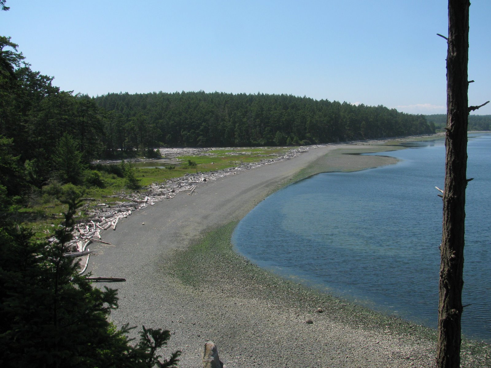
The north and south sides of the peninsula that ends in Cattle Point couldn't be much different. The south side is high grassy bluffs looking over the broad gravel strand of South Beach and twenty miles of water at the Olympic Mountains. The north side is forested and slopes down to Griffin Bay, where it is broken into a wonderful series of barrier lagoons. At the west end, down towards Fourth of July Beach, is Old Town Lagoon. At the east end, down towards Cape San Juan and it's exclusive nest of high end real estate, is Third Lagoon. And in the middle is Jakle's Lagoon, with it's gravel barrier, its lagoon, and its forest.

There is some evidence of an occasional tidal opening near the west end, but certainly not a persistent or regular connection.
The wide gravel barrier gives rise to a broad marsh and eventually to a lagoon, its edges lined thickly with old drift logs. The pickle weed (
Salicornia virginica) was doing its best to survive a colorful infestation of dodder (Cuscuta salina), a plant parasite that apparently takes many forms the world over.

I walked the cobbly beach to Third Lagoon, and then worked my way back via the mossy trail that follows the top edge of the bluff. On one shady section of beach, the upper intertidal gravel was covered with small snails
(Littorina littorea, I assume). I've never seen them gathered so densely and have no explanation.

I've exceeded by usual quota of Latin, normally enforced by my ignorance of biology. Fortunately, the evening that followed this great day of beaches included dinner with people who actually understand this stuff.

Cattle Point


Cattle Point is a rocky headland at the south east end of San Juan Island, jutting out into the eastern end of the Strait of Juan de Fuca. The lighthouse is perched on dunes, which are in turn perched on top of glacial sediments, which in turn mantle the underlying bedrock. There are a couple of wonderful pocket beaches just north around the corner and South Beach stretches out to the west.

Ship Harbor


Ship Harbor is a north-facing cove just east of the Anacortes Ferry Terminal. It's a swash-aligned barrier beach and marsh with a long and complicated human history. It's basically a pocket beach trapped between Shannon Point and the ferry terminal to the west and the old railroad grade on the east. There may be some sediment trickling in from adjacent shorelines, but certainly no way for it to get out, except by gradual attrition or perhaps some loss offshore.

The shape of the beach is altered a bit by the remains of the old cannery -- metal slag (old tin can cuttings?), concrete foundation piers, and a forest of piles - each with it's own gull. The sand and gravel segregate themselves, both across the profile and along the beach. There was a sandy berm encroaching on the vegetation at the east end, suggesting some accretion there recently.

I'm not sure how the wetland drains - through the berm or through a pipe somewhere out of sight? There is a small "stream" bubbling from a concrete vault on the east end, carrying storm water from the new subdivision on the hill. It forms a small low tide delta -which is probably the sink for any extra sediment that makes its way to this end of the bay.

Ship Harbor, February 2009


Saturday, May 21, 2011

Seattle


The eastern shore of Elliott Bay was once a gravel beach with a steep bluff gradually rising from south to north, perhaps 80-100' high in the vicinity of Bell Street. But one thing leads to another and now the bluff is hidden in the jungle of buildings and roadways between Alaskan Way and Western Avenue. The waterfront was built on piers and wharves, then railroads were built parallel to shore (but over the beach), and then eventually, everything was filled in and the current seawall was built.

Now the seawall is being redesigned, the viaduct is slated for removal, and the city has embarked on a grand and long overdue scheme to redevelop its waterfront into a world-class urban shoreline. Thursday night, James Corner provided additional glimpses into the emerging ideas for this stretch of forested bluff and log-strewn beach at the mouth of the Duwamish River.

WaterfrontSeattle

Cape George


Cape George is a large residential development west of Port Townsend. It faces northwest across the mouth of Discovery Bay, looking out over Protection Island and the Strait of Juan de Fuca. Were it not for Protection Island, I suspect the shoreline would look very different, as the island is appropriately named (by George Vancouver back in 1792).

The community's primary link to the beach is a marina and community center built on an old spit and salt marsh - littoral drift is from north to south and sediment that bypasses the jetty is periodically dredged from the channel and placed on the beach immediately south.

The high bluff around the corner to the north has been active this winter, encouraged by the wet weather and stratigraphy that lends itself to hydrologically induced mid-bluff failures. There are massive clays or silts at the toe of the slope - in most cases, the slides have come down from above, although farther northeast, it looks like some historic slides may have cut deeper into this unit. There is a nice contrast between the heavily deformed fine-grained unit at the base and beautiful horizontally laminated sands higher in the bluff.

Port Hadlock


Small, sheltered beaches often seem much more complicated than big, high energy ones. High energy ocean beaches with abundant sediment are just a simple (hah!) balance of wave energy and sediment mobility - the math is hard, but the geology is straightforward, almost absent. But these protected systems are a messy combination of an inherited landscape, a complex geologic framework, a spatially variable wave environment, the role of mixed grain size, often sediment-limited beaches, and the persistence of past human modifications.

Port Hadlock is located at the south end of Port Townsend Bay - where northerly waves dominate and Tertiary bedrock makes one of its rare Puget Sound appearances. Hadlock Spit extends southward from the boat building school, approaching but missing rocky Skunk Island down near the old alcohol plant (as usual, click on the title of the post for the aerial/map view). The beach beneath the boat yard appears to have built seaward, maybe as a lingering result of more than a century of piers and moored ships (and maybe an abundance of sand from the huge fill up at Irondale?). But this sandy beach narrows rapidly just north, with the tide lines swinging landward as if at the end of a spit (starved by the updrift accretion?). But the gravelly beach continues south. The boat ramp is built below the current beach grade, so sandy gravel constantly accumulates and is removed and put in a pile that then gradually erodes. But despite this miniature bypass operation, the shoreline another hundred yards south is eroding, undermining the road out to the private property on the spit itself.

I have few answers, only ideas and questions. Someday I would love to get together with the regular readers of the blog (all 3 of them?) at the Ajax Cafe to figure this all out (funny hats are optional)!

Monday, May 09, 2011

Craft Island


As the Skagit Delta has expanded into Puget Sound, it has gradually engulfed the small islands that once must have dotted the northern portion of what was once a much larger Skagit Bay. Some of these islands are larger than others - Fidalgo Island, for example, which is only still an island by virtue of the Swinomish Channel. Most of these islands are simply hills now, rising out of the miles of low, flat tulip and mustard seed fields. Some are tiny rock dimples - by sheer luck rising slightly higher than modern sea level - juxtaposing ancient bedrock ledges against acres of tide flat and salt marsh.

If you drive to the west end of Rawlins Road (turn at the Snow Goose farm stand) and park, you can find a half-mile trail that skirts the high marsh out to this rocky knob. And if the tide is low, you can just keep on walking for miles.