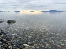
Puget Sound Beaches ... not really just gravel, but sand, broken shell, and occasionally a boulder the size of a large truck.
Thursday, March 05, 2015
Point Whitehorn
The gravel wasn't going anywhere on this very calm day several weeks ago!
The Point Whitehorn Marine Reserve provides access to this coarse pebble beach just south of Point Whitehorn itself and a short distance north of the pier at BP's Cherry Point refinery. A short trail through the woods leads to a set of stairs down to the beach. One benefit of the industrial zoning along this reach is that the rest of the shoreline is relatively untouched - anywhere else it would be a continuous line of 5000 square foot houses, beach stairs, and seawalls!
Eroding till and glacial marine drift (I think both are present along here) provides a stream of coarse gravel and boulders that arrive by occasional landslides. A quick glance at the bluff face identifies more boulders that will join those on the beach in coming decades. The beach is coarse - mainly pebbles and coarse gravel -- but with patches of finer gravel and sand below recent slides, in the lee of large boulders, and occasionally just smeared out along the upper beach for no apparent reason.
AERIAL VIEW
The direction of sediment transport along here has always been a little controversial. Predominant southerly wave action would suggest northward transport, but Sandy Point, the large spit a few miles south of here, sort of indicates the opposite. The argument for this is that the large fetch from the northwest might allow less frequent, but more powerful wave events to move stuff southward.
Just today - and unrelated to my recent visit - I received a copy of Meghan Weaver's thesis (thanks, Scott). I haven't had a chance to look at it in detail, but she traced cobbles using RF tags and used models to get at this question. Most of her cobbles moved northwest in response to southerly wave action during experiments in winter, 2012 - but a major storm with waves from the west showed that the largest waves may be able to move significant amounts of material a long ways in the other direction.
Fetch, and therefore the largest waves in this fetch-limited system, may be be crucial to understanding long-term patterns in coarse sediment transport, even if the sense of direction is different than that dictated by more routine wind and wave patterns.
Meghan also makes some other important observations about the importance of the tidal stage in influencing patterns of movement and about the relative mobility of the upper and lower foreshore (material moves more on the upper beach). Ultimately, what she shows is that simple models of longshore sediment movement are ... well, simple. So neat to have a new generation of geologists that are actually using data and realistic models to get at things the rest of us have been speculating about for decades!


No comments:
Post a Comment