Puget Sound Beaches ... not really just gravel, but sand, broken shell, and occasionally a boulder the size of a large truck.
Sunday, October 16, 2011
Myrtle Edwards Park
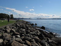
The beach and high bluff that marked the original shoreline is hundreds of yards inland at the foot of Queen Anne Hill. Elliott Avenue, the railroad, and Myrtle Edwards Park are all fill (most derived from the leveling of lower Queen Anne and the regrade, I believe), which means the park's waterward edge drops pretty steeply to subtidal depths.
Most of the shoreline is riprap, which may be effective at preventing the fill from eroding back into the Sound, but which is ugly and makes getting to the water unappealing and difficult. Shorelines are special places. Industrial ones require industrial solutions, but public ones require imaginative and welcoming ones. If rock is necessary, maybe an investment in better rock would be a start. Vancouver has used large granitic boulders on its English Bay shoreline, which encourage sitting and even allow safer access to the water itself. Sure it's more expensive, but it's also a nice place to linger, not just roller blade past.
But best of all is when the the configuration of the shoreline allows beaches. This one is somewhat incidental, I believe, but could probably be expanded. It flies in the face of anyone who would argue that the energy or the steepness of the shoreline preclude a sandier beach.
There is another pocket beach just down the shoreline at the Denny Street outfall - they added gravel to a small pocket a few years ago and it's shaped up nicely. And a little beyond that is the Sculpture Park beach. I'll add pictures of those in subsequent posts. There is talk of incorporating beaches into the reshaped central waterfront, too. I suspect as we move farther south, the beaches will continue to become progressively more engineered and less natural, although this may have more to do with design firms and big budgets than any natural limitations of the sites. I'll put in a strong plug for imagination and for learning from natural examples.


No comments:
Post a Comment