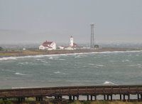

A blustery day in Port Townsend. Strong winds out of the south and a high tide. A plume of sediment traveled north along the beach toward the point, though it looked like it was taking a detour around the pier/jetty and the Marine Science Center. Nearshore waters always get muddy (silty?) after heavy rains and when waves are churning up the beach, but these were probably exacerbated by the very recent landslides between the Fort and Chetzamoka Park - since the tide was probably eating directly into the fresh dirt.
Out at the lighthouse, the waves were wrapping sharply around the point, breaking westward along the north beach. The south beach at Point Wilson is swash-aligned and you could see it today - waves at the pier were breaking to the northeast and waves at the point were breaking southwest - with a null point somewhere in the middle. This may be why the south side of Point Wilson appears to be building - it is collecting sediment both from the bluffs to the south and from the persistent erosion of the north side of the point. It's hard to conjure a storm that would erode the south beach significantly. (I guess this may need a cartoon to really understand).

Postscript: JAPANESE TSUNAMI? I was looking at the tide record for Port Townsend during the storm,which shows the 8.3' midday high tide coming in at almost 10', and noticed some interesting one-hour wobbles in the water level curve that lasted all afternoon. They are only a few inches in amplitude, but it just happens that Wednesday afternoon is when the Kurile Island tsunami reached Crescent City and the rest of the west coast of North America! The pictures above were taken about 1:20PM local time - though conditions weren't exactly conducive to observing a 3" tsunami! Probably requires some more analysis to confirm, but tantalizing.
No comments:
Post a Comment